Պատկեր:United Kingdom United States Locator.svg

Size of this PNG preview of this SVG file: 800 × 353 պիքսել. Այլ թույլտվությաններ: 320 × 141 պիքսել | 640 × 283 պիքսել | 1024 × 452 պիքսել | 1280 × 565 պիքսել | 2560 × 1130 պիքսել | 940 × 415 պիքսել.
Սկզբնական նիշք (SVG-նիշք, անվանապես 940 × 415 փիքսել, նիշքի չափը՝ 2,56 ՄԲ)
Ամփոփում
| Նկարագրում |
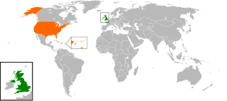
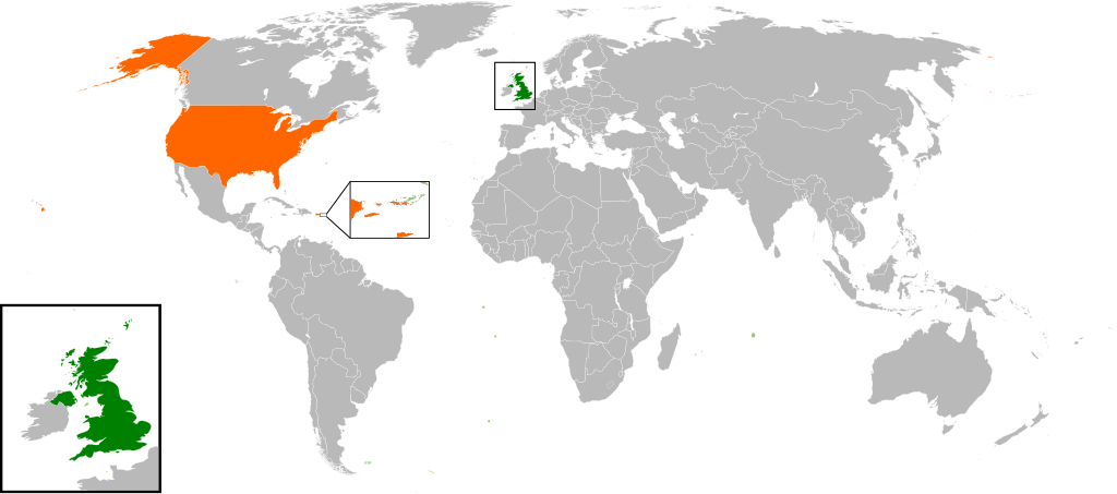
English: Map of the world showing the location of the United Kingdom and the United States of America. |
| Թվական | |
| Աղբյուր | Բեռնողի սեփական աշխատանք |
| Հեղինակ | Jolly Janner |
Արտոնագրում
| I, the copyright holder of this work, release this work into the public domain. This applies worldwide. In some countries this may not be legally possible; if so: I grant anyone the right to use this work for any purpose, without any conditions, unless such conditions are required by law. |
Նիշքի պատմություն
Մատնահարեք օրվան/ժամին՝ նիշքի այդ պահին տեսքը դիտելու համար։
| Օր/Ժամ | Մանրապատկեր | Օբյեկտի չափը | Մասնակից | Մեկնաբանություն | |
|---|---|---|---|---|---|
| ընթացիկ | 16:00, 20 Մարտի 2017 | | 940 × 415 (2,56 ՄԲ) | RaviC | add dependencies, inset map for Virgin Islands region where both states share a maritime border |
| 02:43, 24 Դեկտեմբերի 2016 |  | 940 × 415 (1,79 ՄԲ) | BurritoBazooka | put all Faroe islands except Suðuroy region behind black border of UK box. Make two boxes (transparent group rectangle and white bg rectangle) same stroke thickness. | |
| 00:43, 24 Դեկտեմբերի 2016 |  | 940 × 415 (1,79 ՄԲ) | BurritoBazooka | add France and Faroe Islands to UK box by re-cutting it from its place on the map (b/c why should ROI, another sovereign state, be shown, and not France and the Faroe Islands?) Also the box has its own group now. | |
| 00:34, 24 Դեկտեմբերի 2016 |  | 940 × 415 (1,78 ՄԲ) | BurritoBazooka | French Polynesia, Pitcairn Islands were showing in the UK box, but these are not in the same area as the British Isles at all. Also, are Falklands etc not on the same level as Puerto Rico? | |
| 18:38, 7 Դեկտեմբերի 2016 |  | 940 × 415 (1,78 ՄԲ) | Mikey641 | Accident | |
| 18:38, 7 Դեկտեմբերի 2016 |  | 512 × 226 (753 ԿԲ) | Mikey641 | -- | |
| 18:09, 3 Մարտի 2013 |  | 940 × 415 (1,78 ՄԲ) | Timothy Gu | +South Sudan (w/ small Britain map) | |
| 21:25, 2 Մարտի 2012 |  | 940 × 415 (1,63 ՄԲ) | Jrobin08 | Reverted to version as of 20:37, 24 June 2009 (Easier to see the United Kingdom. Maybe someone can add South Sudan to the map, but keep the UK zoom box in.) | |
| 21:05, 23 Սեպտեմբերի 2011 |  | 940 × 415 (1,76 ՄԲ) | Bazonka2 | + South Sudan | |
| 20:37, 24 Հունիսի 2009 |  | 940 × 415 (1,63 ՄԲ) | Jolly Janner | {{Information |Description={{en|1=Map of the world showing the location of the United Kingdom and the United States of America.}} |Source=Own work by uploader |Author=Jolly Janner |Date=2009-0 |
Նիշքի օգտագործում
Հետևյալ էջը հղվում է այս նիշքին՝
Նիշքի համընդհանուր օգտագործում
Հետևյալ այլ վիքիները օգտագործում են այս նիշքը՝
- Օգտագործումը ar.wikipedia.org կայքում
- Օգտագործումը ca.wikipedia.org կայքում
- Օգտագործումը de.wikipedia.org կայքում
- Օգտագործումը en.wikipedia.org կայքում
- Օգտագործումը es.wikipedia.org կայքում
- Օգտագործումը fr.wikipedia.org կայքում
- Օգտագործումը he.wikipedia.org կայքում
- Օգտագործումը id.wikipedia.org կայքում
- Օգտագործումը it.wikipedia.org կայքում
- Օգտագործումը ja.wikipedia.org կայքում
- Օգտագործումը ps.wikipedia.org կայքում
- Օգտագործումը pt.wikipedia.org կայքում
- Օգտագործումը ru.wikipedia.org կայքում
- Օգտագործումը th.wikipedia.org կայքում
- Օգտագործումը tr.wikipedia.org կայքում
- Օգտագործումը uk.wikipedia.org կայքում
- Օգտագործումը www.wikidata.org կայքում
- Օգտագործումը zh.wikipedia.org կայքում