Պատկեր:Roman Empire full - Referenced.jpg
Նախադիտման չափ՝ 749 × 599 պիքսել։ Այլ թույլտվությաններ: 300 × 240 պիքսել | 600 × 480 պիքսել | 960 × 768 պիքսել | 1116 × 893 պիքսել.
Սկզբնական նիշք (1116 × 893 փիքսել, նիշքի չափը՝ 303 ԿԲ, MIME-տեսակը՝ image/jpeg)
Ամփոփում
| Նկարագրում |
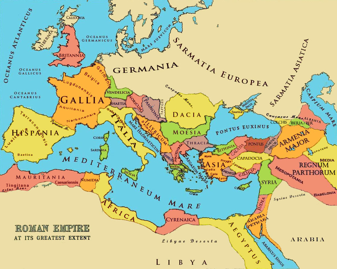
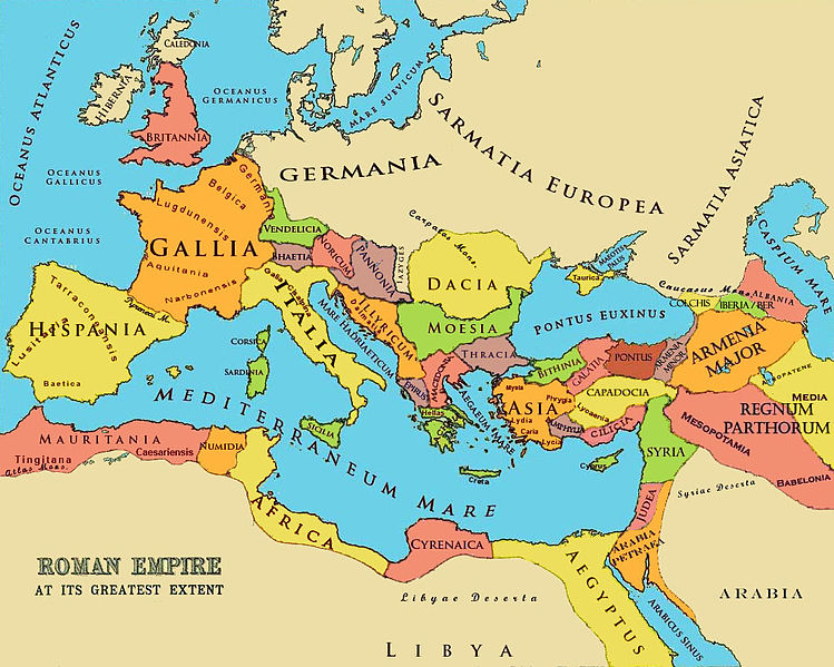
English: A referenced map of the Roman Empire at its greatest extent in the 2-3 cc. The borders of states and markings are referenced to a published historical atlas in public domain. |
| Թվական | 21 Մայիս 2010 (original upload date); 26 Հունիս 2010 (last version) |
| Աղբյուր |
|
| Հեղինակ |
Aregakn at en.wikipedia. Later versions were uploaded by Beao at en.wikipedia. |


Արտոնագրում
Aregakn at en.wikipedia, այս աշխատանքի հեղինակային իրավունքների տերը, կամավոր հրապարակում եմ այն հետևյալ լիցենզիաների պայմաններով.
Այս նիշքը հասանելի է Creative Commons Attribution-Share Alike 3.0 Unported արտոնագրի ներքո:
Հղում: Aregakn at en.wikipedia
- Դուք ազատ եք՝
- կիսվել ստեղծագործությամբ – պատճենել, տարածել և փոխանցել այս աշխատանքը։
- վերափոխել – ադապտացնել աշխատանքը
- Պահպանելով հետևյալ պայմանները'
- հղում – Դուք պետք է նշեք հեղինակի (իրավատիրոջ) հղումը:
- համանման տարածում – Եթե դուք ձևափոխում եք, փոխակերպում, կամ այս աշխատանքի հիման վրա ստեղծում եք նոր աշխատանք, ապա ձեր ստեղծածը կարող է տարածվել միայն նույն կամ համարժեք թույլատրագրով։

|
Այս վավերագրման պատճենահանման, տարածման և/կամ ձևափոխման թույլտվություն կամ լիցենզիայի GNU FDL պայմաններով 1.2 մեկնակերպի կամ ավելի ուշ, հրատարակված Ազատ ծրագրային ապահովության հիմնադրամում, առանց անփոփոխելի հատվածների, առանց բնագիրների, որոնք տեղադրված են առաջին և վերջին շապիկներում: Լիցենզիայի պատճենը գտնվում է GNU Free Documentation License հատվածում: |
Կարող եք ընտրել այս թույլատրագրերից ցանկացածը։
Original upload log
The original description page was here. All following user names refer to en.wikipedia.
- 2010-06-26 13:26 Beao 1116×893× (309793 bytes)
- 2010-05-29 06:05 Aregakn 1119×897× (258809 bytes) less colorful
- 2010-05-21 09:36 Aregakn 1119×897× (204488 bytes) A referenced map of the Roman Empire at it's greatest extent in the 2-3 cc. The borders of states and markings are referenced to a published historical atlas in public domain. Ref: [http://people.ucalgary.ca/~vandersp/Courses/maps/basicmap.html]
Նիշքի պատմություն
Մատնահարեք օրվան/ժամին՝ նիշքի այդ պահին տեսքը դիտելու համար։
| Օր/Ժամ | Մանրապատկեր | Օբյեկտի չափը | Մասնակից | Մեկնաբանություն | |
|---|---|---|---|---|---|
| ընթացիկ | 01:18, 3 Օգոստոսի 2011 | | 1116 × 893 (303 ԿԲ) | OgreBot | (BOT): Reverting to most recent version; originally uploaded at en.wikipedia on 2010-06-26 13:26:19 by Beao |
| 01:18, 3 Օգոստոսի 2011 |  | 1119 × 897 (253 ԿԲ) | OgreBot | (BOT): Uploading old version of file from en.wikipedia; originally uploaded on 2010-05-29 06:05:55 by Aregakn | |
| 01:18, 3 Օգոստոսի 2011 |  | 1119 × 897 (200 ԿԲ) | OgreBot | (BOT): Uploading old version of file from en.wikipedia; originally uploaded on 2010-05-21 09:36:27 by Aregakn | |
| 21:51, 7 Հունիսի 2011 |  | 1116 × 893 (303 ԿԲ) | Davius |
Նիշքի օգտագործում
Հետևյալ էջը հղվում է այս նիշքին՝
Նիշքի համընդհանուր օգտագործում
Հետևյալ այլ վիքիները օգտագործում են այս նիշքը՝
- Օգտագործումը ar.wikipedia.org կայքում
- Օգտագործումը bg.wikipedia.org կայքում
- Օգտագործումը ca.wikipedia.org կայքում
- Օգտագործումը en.wikipedia.org կայքում
- Օգտագործումը es.wikipedia.org կայքում
- Օգտագործումը fr.wiktionary.org կայքում
- Օգտագործումը hyw.wikipedia.org կայքում
- Օգտագործումը it.wikipedia.org կայքում
- Օգտագործումը it.wikibooks.org կայքում
- Օգտագործումը ms.wikipedia.org կայքում
- Օգտագործումը tr.wikipedia.org կայքում