Պատկեր:Peel-Commission Report Map1 AdminDistrictsSyriaPalestine 1154x1846.png

Նախադիտման չափ՝ 375 × 600 պիքսել։ Այլ թույլտվությաններ: 150 × 240 պիքսել | 300 × 480 պիքսել | 480 × 768 պիքսել | 1154 × 1846 պիքսել.
Սկզբնական նիշք (1154 × 1846 փիքսել, նիշքի չափը՝ 36 ԿԲ, MIME-տեսակը՝ image/png)
| Նկարագրում |
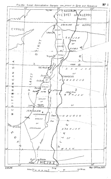
English: Pre-war Turkish Administrative Districts comprised in Syria and Palestine. Map No. 1 of the Peel Commission Report, presented to illustrate the Vilayets and Sandjaks mentioned in the 1915-10-24 en:McMahon Letters (McMahon Pledge, see also en:McMahon–Hussein Correspondence), showing the Ottoman adminstrative divisions.
This is the original scan from the scanned copy of the Peel Report as found on the UNISPAL library of the United Nations. |
|||
| Թվական | ||||
| Աղբյուր | Palestine Royal Commission (Peel Commission), Report, Presented by the Secretary of State for the Colonies to Parliament by Command of His Majesty, July 1937. London, His Majesty's Stationary Office, 1937 Download as PDF from UNISPAL:UN.ORG | |||
| Հեղինակ | British War Office, 1937 | |||
| Իրավունքներ (Նիշքի վերաօգտագործումը) |
|


This file was derived from: Pre-war Turkish Administrative Districts comprised in Syria and Palestine of Peel Commission Report 1937.tif
| Սա խմբագրված պատկեր է, որը համեմատ բնօրինակին ենթարկվել է թվային մշակման։ Փոփոխությունները՝ Shadows from wrinkles and crinkles which resulted from folding of the original copy have been cleaned out as much as possible. Unfortunately this was done with a reduced version of the original file. In the larger, the TIF, the mouse danced too much. "Upload a new version of this file" was not possible because this one is PNG while the first upload is TIF:
|
Նիշքի պատմություն
Մատնահարեք օրվան/ժամին՝ նիշքի այդ պահին տեսքը դիտելու համար։
| Օր/Ժամ | Մանրապատկեր | Օբյեկտի չափը | Մասնակից | Մեկնաբանություն | |
|---|---|---|---|---|---|
| ընթացիկ | 11:04, 31 հունվարի 2016 | | 1154 × 1846 (36 ԿԲ) | L.Willms | {{Information |Description ={{en|1=Pre-war Turkish Administrative Districts comprised in Syria and Palestine. Map No. 1 of the Peel Commission Report, presented to illustrate the Vilayets and Sandjaks mentioned in the 1915-10-24 [[:en:McMahon Letter... |
Նիշքի օգտագործում
Հետևյալ էջը հղվում է այս նիշքին՝
Նիշքի համընդհանուր օգտագործում
Հետևյալ այլ վիքիները օգտագործում են այս նիշքը՝
- Օգտագործումը en.wikipedia.org կայքում