Պատկեր:L'île de la Réunion vue par le satellite Sentinel-2 (cropped).jpg

Սկզբնական նիշք (5000 × 4232 փիքսել, նիշքի չափը՝ 18,68 ՄԲ, MIME-տեսակը՝ image/jpeg)
Ամփոփում
| Նկարագրում |
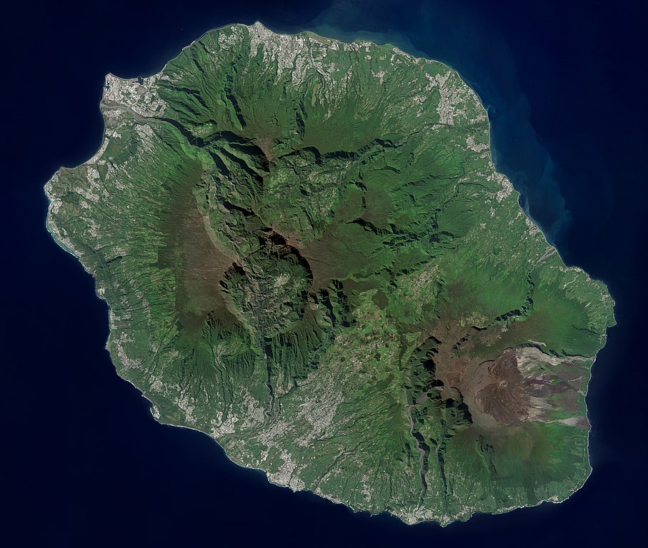
Français : L'île de la Réunion vue par le satellite Sentinel-2
English: Réunion island (Indian Ocean) photographed by Sentinel-2 satellite. |
| Թվական | |
| Աղբյուր | https://phototheque.cnes.fr/cnes/media/68926 |
| Հեղինակ | European Space Agency / CNES |
| Այլ մեկնակերպներ |

.jpg)
| Տեսախցիկի տեղագրություն | | Այս և ուրիշ պատկերներ իրենց տեղագրությամբ OpenStreetMap |
|---|
.jpg¶ms=-21.134472_N_0055.247103_E_globe:Earth_type:camera__&language=hy)
Արտոնագրում

|
This image contains data from a satellite in the Copernicus Programme, such as Sentinel-1, Sentinel-2 or Sentinel-3. Attribution is required when using this image.
Հղում: Contains modified Copernicus Sentinel data 2021
The use of Copernicus Sentinel Data is regulated under EU law (Commission Delegated Regulation (EU) No 1159/2013 and Regulation (EU) No 377/2014). Relevant excerpts:
Free access shall be given to GMES dedicated data [...] made available through GMES dissemination platforms [...].
Access to GMES dedicated data [...] shall be given for the purpose of the following use in so far as it is lawful:
GMES dedicated data [...] may be used worldwide without limitations in time.
GMES dedicated data and GMES service information are provided to users without any express or implied warranty, including as regards quality and suitability for any purpose. |

|
This image has been assessed under the valued image criteria and is considered the most valued image on Commons within the scope: Réunion island, France - satellite view.. You can see its nomination here. |
.jpg)
Նիշքի պատմություն
Մատնահարեք օրվան/ժամին՝ նիշքի այդ պահին տեսքը դիտելու համար։
| Օր/Ժամ | Մանրապատկեր | Օբյեկտի չափը | Մասնակից | Մեկնաբանություն | |
|---|---|---|---|---|---|
| ընթացիկ | 14:12, 6 Սեպտեմբերի 2022 | | 5000 × 4232 (18,68 ՄԲ) | Skimel | File:L'île de la Réunion vue par le satellite Sentinel-2.jpg cropped 15 % vertically using CropTool with precise mode. |
Նիշքի օգտագործում
Հետևյալ էջը հղվում է այս նիշքին՝
Նիշքի համընդհանուր օգտագործում
Հետևյալ այլ վիքիները օգտագործում են այս նիշքը՝
- Օգտագործումը ar.wikipedia.org կայքում
- Օգտագործումը arz.wikipedia.org կայքում
- Օգտագործումը ast.wikipedia.org կայքում
- Օգտագործումը az.wikipedia.org կայքում
- Օգտագործումը ca.wikipedia.org կայքում
- Օգտագործումը ce.wikipedia.org կայքում
- Օգտագործումը cy.wikipedia.org կայքում
- Օգտագործումը diq.wikipedia.org կայքում
- Օգտագործումը es.wikipedia.org կայքում
- Օգտագործումը es.wikivoyage.org կայքում
- Օգտագործումը fr.wikinews.org կայքում
- Օգտագործումը fr.wikivoyage.org կայքում
- Օգտագործումը ga.wikipedia.org կայքում
- Օգտագործումը gl.wikipedia.org կայքում
- Օգտագործումը ht.wikipedia.org կայքում
- Օգտագործումը ia.wikipedia.org կայքում
- Օգտագործումը ig.wikipedia.org կայքում
- Օգտագործումը ku.wikipedia.org կայքում
- Օգտագործումը no.wikipedia.org կայքում
- Օգտագործումը oc.wikipedia.org կայքում
- Օգտագործումը pl.wikipedia.org կայքում
- Օգտագործումը ps.wikipedia.org կայքում
- Օգտագործումը tl.wikipedia.org կայքում
- Օգտագործումը vec.wikipedia.org կայքում
- Օգտագործումը vi.wikipedia.org կայքում
- Օգտագործումը www.wikidata.org կայքում
.jpg)