Պատկեր:Carlsbad districts.png
Նախադիտման չափ՝ 778 × 600 պիքսել։ Այլ թույլտվությաններ: 312 × 240 պիքսել | 623 × 480 պիքսել | 955 × 736 պիքսել.
Սկզբնական նիշք (955 × 736 փիքսել, նիշքի չափը՝ 13 ԿԲ, MIME-տեսակը՝ image/png)
Ամփոփում
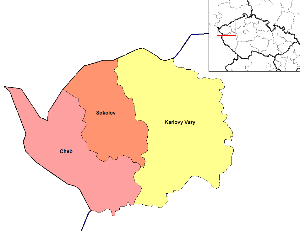
| Նկարագրում | Map of the districts of Carlsbad region of the Czech Republic. Created by Rarelibra 15:06, 2 January 2007 (UTC) for public domain use, using MapInfo Professional v8.5 and various mapping resources. |
| Թվական | 2 Հունվար 2007 (original upload date) |
| Աղբյուր | No machine-readable source provided. Own work assumed (based on copyright claims). |
| Հեղինակ | No machine-readable author provided. Rarelibra assumed (based on copyright claims). |
Արտոնագրում
| I, the copyright holder of this work, release this work into the public domain. This applies worldwide. In some countries this may not be legally possible; if so: I grant anyone the right to use this work for any purpose, without any conditions, unless such conditions are required by law. |
Նիշքի պատմություն
Մատնահարեք օրվան/ժամին՝ նիշքի այդ պահին տեսքը դիտելու համար։
| Օր/Ժամ | Մանրապատկեր | Օբյեկտի չափը | Մասնակից | Մեկնաբանություն | |
|---|---|---|---|---|---|
| ընթացիկ | 17:02, 5 Հունիսի 2023 | | 955 × 736 (13 ԿԲ) | Horecak | Cropped 10 % horizontally, 10 % vertically using CropTool with lossless mode. |
| 15:06, 2 հունվարի 2007 |  | 1056 × 816 (22 ԿԲ) | Rarelibra | Map of the districts of Carlsbad region of the Czech Republic. Created by ~~~~ for public domain use, using MapInfo Professional v8.5 and various mapping resources. |
Նիշքի օգտագործում
Հետևյալ էջը հղվում է այս նիշքին՝
Նիշքի համընդհանուր օգտագործում
Հետևյալ այլ վիքիները օգտագործում են այս նիշքը՝
- Օգտագործումը ar.wikipedia.org կայքում
- Օգտագործումը bg.wikipedia.org կայքում
- Օգտագործումը br.wikipedia.org կայքում
- Օգտագործումը ca.wikipedia.org կայքում
- Օգտագործումը ce.wikipedia.org կայքում
- Օգտագործումը cs.wikipedia.org կայքում
- Օգտագործումը da.wikipedia.org կայքում
- Օգտագործումը de.wikipedia.org կայքում
- Օգտագործումը en.wikipedia.org կայքում
- Օգտագործումը es.wikipedia.org կայքում
- Օգտագործումը fa.wikipedia.org կայքում
- Օգտագործումը frr.wikipedia.org կայքում
- Օգտագործումը fr.wikipedia.org կայքում
- Օգտագործումը hu.wikipedia.org կայքում
- Օգտագործումը it.wikipedia.org կայքում
- Օգտագործումը ja.wikipedia.org կայքում
- Օգտագործումը ka.wikipedia.org կայքում
- Օգտագործումը ko.wikipedia.org կայքում
- Օգտագործումը la.wikipedia.org կայքում
- Օգտագործումը lmo.wikipedia.org կայքում
- Օգտագործումը lt.wikipedia.org կայքում
- Օգտագործումը mk.wikipedia.org կայքում
- Օգտագործումը ms.wikipedia.org կայքում
- Օգտագործումը no.wikipedia.org կայքում
- Օգտագործումը or.wikipedia.org կայքում
- Օգտագործումը pam.wikipedia.org կայքում
- Օգտագործումը pl.wikipedia.org կայքում
- Օգտագործումը pnb.wikipedia.org կայքում
- Օգտագործումը pt.wikipedia.org կայքում
- Օգտագործումը ro.wikipedia.org կայքում
- Օգտագործումը ru.wikipedia.org կայքում
- Օգտագործումը simple.wikipedia.org կայքում
- Օգտագործումը sl.wikipedia.org կայքում
- Օգտագործումը sq.wikipedia.org կայքում
- Օգտագործումը sv.wikipedia.org կայքում
- Օգտագործումը tr.wikipedia.org կայքում
- Օգտագործումը uk.wikipedia.org կայքում
Տեսնել այս նիշքի ավելի համընդհանուր օգտագործումը: