Պատկեր:Trockenklimate.png
Նախադիտման չափ՝ 800 × 400 պիքսել։ Այլ թույլտվությաններ: 320 × 160 պիքսել | 640 × 320 պիքսել | 1024 × 512 պիքսել | 1280 × 640 պիքսել | 3600 × 1800 պիքսել.
Սկզբնական նիշք (3600 × 1800 փիքսել, նիշքի չափը՝ 647 ԿԲ, MIME-տեսակը՝ image/png)
Ամփոփում
| Description |
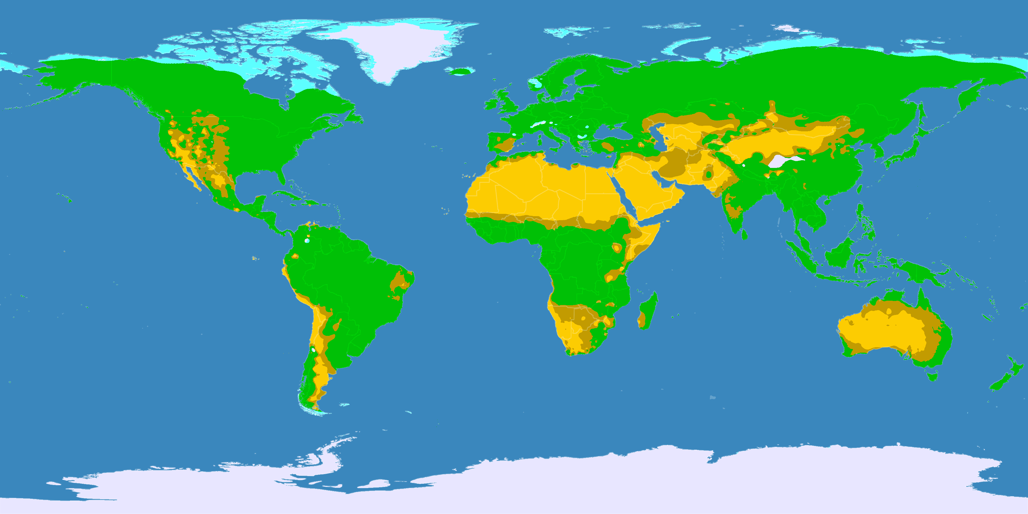
English: This map shows the Earth zones with a dry climate.
Desert climate
Savanna climate
Tundra climate
Ice cap climate
Deutsch: Diese Karte zeigt die verschiedenen trockenen Klimazonen der Erde.
Wüstenklima
Savannenklima
Tundrenklima
Eisklima
Italiano: Mappa delle zone desertiche
Deserto
Savana
Tundra
Clima glaciale
Norsk bokmål: Kart over verdens tørre klimasoner.
Ørken
Savanne
Tundra
Iskalottene |
||
| Թվական | |||
| Աղբյուր |
English: Own work on the basis of the following data: Deutsch: Selbst erstellt auf Basis dieser Geodaten:
|
||
| Ստեղծել է | |||
| Իրավունքներ (Նիշքի վերաօգտագործումը) |
|||
| Georeferencing | If inappropriate please set warp_status = skip to hide. | ||
| Այլ մեկնակերպներ |
|


Արտոնագրում
Այս նիշքը հասանելի է Creative Commons Attribution-Share Alike 3.0 Unported արտոնագրի ներքո:
- Դուք ազատ եք՝
- կիսվել ստեղծագործությամբ – պատճենել, տարածել և փոխանցել այս աշխատանքը։
- վերափոխել – ադապտացնել աշխատանքը
- Պահպանելով հետևյալ պայմանները'
- հղում – Դուք պետք է նշեք հեղինակի (իրավատիրոջ) հղումը:
- համանման տարածում – Եթե դուք ձևափոխում եք, փոխակերպում, կամ այս աշխատանքի հիման վրա ստեղծում եք նոր աշխատանք, ապա ձեր ստեղծածը կարող է տարածվել միայն նույն կամ համարժեք թույլատրագրով։
Նիշքի պատմություն
Մատնահարեք օրվան/ժամին՝ նիշքի այդ պահին տեսքը դիտելու համար։
| Օր/Ժամ | Մանրապատկեր | Օբյեկտի չափը | Մասնակից | Մեկնաբանություն | |
|---|---|---|---|---|---|
| ընթացիկ | 21:03, 11 Հոկտեմբերի 2016 | | 3600 × 1800 (647 ԿԲ) | Maphobbyist | The Caspian Sea was omitted. The Köppen system is based on the concept that climate types are correlated with the natural vegetation. |
| 12:25, 29 հունվարի 2013 |  | 3600 × 1800 (530 ԿԲ) | GDK | humid areas colured green (formerly light grey) for better recognizability | |
| 17:25, 15 Հոկտեմբերի 2007 |  | 3600 × 1800 (623 ԿԲ) | Lortordermur | == Beschreibung == {{Information |Description=Diese Karte stellt die trockenen Klimate der Erde dar. {{legend|#ffcc00|Wüstenklima}} {{legend|#c69e00|Savannenklima}} {{legend|#65ffff|Tundrenklima}} {{legend|#eaeaff|Eisklima}} |Source=Selbst erstellt auf |
Նիշքի օգտագործում
Հետևյալ էջը հղվում է այս նիշքին՝
Նիշքի համընդհանուր օգտագործում
Հետևյալ այլ վիքիները օգտագործում են այս նիշքը՝
- Օգտագործումը ba.wikipedia.org կայքում
- Օգտագործումը bg.wikipedia.org կայքում
- Օգտագործումը ce.wikipedia.org կայքում
- Օգտագործումը ckb.wikipedia.org կայքում
- Օգտագործումը crh.wikipedia.org կայքում
- Օգտագործումը da.wikipedia.org կայքում
- Օգտագործումը da.wikibooks.org կայքում
- Օգտագործումը de.wikipedia.org կայքում
- Օգտագործումը de.wikiversity.org կայքում
- Օգտագործումը eo.wikipedia.org կայքում
- Օգտագործումը et.wikipedia.org կայքում
- Օգտագործումը fa.wikipedia.org կայքում
- Օգտագործումը fi.wikipedia.org կայքում
- Օգտագործումը frr.wikipedia.org կայքում
- Օգտագործումը hu.wikipedia.org կայքում
- Օգտագործումը hyw.wikipedia.org կայքում
- Օգտագործումը inh.wikipedia.org կայքում
- Օգտագործումը it.wikipedia.org կայքում
- Օգտագործումը ja.wikipedia.org կայքում
- Օգտագործումը kaa.wikipedia.org կայքում
- Օգտագործումը ka.wikipedia.org կայքում
- Օգտագործումը krc.wikipedia.org կայքում
- Օգտագործումը la.wikipedia.org կայքում
- Օգտագործումը lld.wikipedia.org կայքում
- Օգտագործումը lv.wikipedia.org կայքում
- Օգտագործումը nds.wikipedia.org կայքում
- Օգտագործումը nl.wikipedia.org կայքում
- Օգտագործումը no.wikipedia.org կայքում
- Օգտագործումը pt.wikipedia.org կայքում
- Օգտագործումը roa-tara.wikipedia.org կայքում
- Օգտագործումը ro.wikipedia.org կայքում
- Օգտագործումը ru.wikipedia.org կայքում
- Օգտագործումը sc.wikipedia.org կայքում
- Օգտագործումը sr.wikipedia.org կայքում
- Օգտագործումը sv.wikipedia.org կայքում
Տեսնել այս նիշքի ավելի համընդհանուր օգտագործումը: