Պատկեր:Tianjin, China ESA15420167.tiff

Սկզբնական նիշք (5000 × 3549 փիքսել, նիշքի չափը՝ 44,72 ՄԲ, MIME-տեսակը՝ image/tiff)
Ամփոփում
| Նկարագրում |
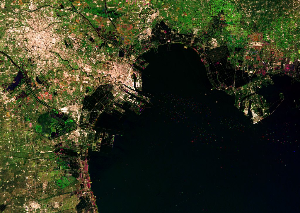
English: The Chinese city of Tianjin is captured in this Sentinel-1A radar image created by combining three scans over several months. The city sits to the west of the Bohai Bay within the Bohai Gulf, off of the Yellow Sea. With a population of over 14 million people, this megacity is among China’s five largest. Urban areas are home to over half of the world’s population, and are rapidly changing environments. As more people move from rural areas to cities, this growth needs to be monitored to help it proceed on a sustainable basis. High-resolution satellite data provide essential information for city planning and for the sustainable development of urban regions. Radar in particular can be used to monitor slight ground movements down to a few millimetres – valuable information for urban planners and for risk assessment. Zooming in on the upper right, we can see different colours in the geometric agricultural fields, showing changes between the three acquisitions (22 October 2014, 14 January 2015 and 7 February 2015) that make up this image. In this area, the black shapes show divided areas covered in water, which are possibly shrimp or fish farms. Bohai Bay was traditionally home to the country’s richest fisheries, but pollution, overfishing and land reclamation has diminished this economic activity. Farther south, we can see numerous dots in the water – radar reflections from the boats coming to and from the Port of Tianjin. This massive maritime gateway handles hundreds of millions of tonnes of cargo each year, and is the largest in northern China. On the central-left side of the image, the black and bright green areas are water reservoirs. The upcoming Sentinel-2 mission – set for launch on 22 June – will be used to support the sustainable management of water resources by providing measurements of water quality and detecting changes. This image is also featured on the Earth from Space video programme. |
| Թվական | 5 Հունիս 2015 (upload date) |
| Աղբյուր | Tianjin, China |
| Հեղինակ | European Space Agency |
| Այլ մեկնակերպներ |
|
| Activity | Observing the Earth |
| Keyword | City Urban areas Radar Images |
| Location | China |
| Mission | Sentinel-1 |
| Set | Earth observation image of the week |
| System | Copernicus |

Արտոնագրում

|
This image contains data from a satellite in the Copernicus Programme, such as Sentinel-1, Sentinel-2 or Sentinel-3. Attribution is required when using this image.
Հղում: Contains modified Copernicus Sentinel data 2014/2015
The use of Copernicus Sentinel Data is regulated under EU law (Commission Delegated Regulation (EU) No 1159/2013 and Regulation (EU) No 377/2014). Relevant excerpts:
Free access shall be given to GMES dedicated data [...] made available through GMES dissemination platforms [...].
Access to GMES dedicated data [...] shall be given for the purpose of the following use in so far as it is lawful:
GMES dedicated data [...] may be used worldwide without limitations in time.
GMES dedicated data and GMES service information are provided to users without any express or implied warranty, including as regards quality and suitability for any purpose. |
This media was created by the European Space Agency (ESA).
Where expressly so stated, images or videos are covered by the Creative Commons Attribution-ShareAlike 3.0 IGO (CC BY-SA 3.0 IGO) licence, ESA being an Intergovernmental Organisation (IGO), as defined by the CC BY-SA 3.0 IGO licence. The user is allowed under the terms and conditions of the CC BY-SA 3.0 IGO license to Reproduce, Distribute and Publicly Perform the ESA images and videos released under CC BY-SA 3.0 IGO licence and the Adaptations thereof, without further explicit permission being necessary, for as long as the user complies with the conditions and restrictions set forth in the CC BY-SA 3.0 IGO licence, these including that:
See the ESA Creative Commons copyright notice for complete information, and this article for additional details.
|
 | |
This file is licensed under the Creative Commons Attribution-ShareAlike 3.0 IGO license. Հղում: ESA, CC BY-SA IGO 3.0
| ||
Նիշքի պատմություն
Մատնահարեք օրվան/ժամին՝ նիշքի այդ պահին տեսքը դիտելու համար։
| Օր/Ժամ | Մանրապատկեր | Օբյեկտի չափը | Մասնակից | Մեկնաբանություն | |
|---|---|---|---|---|---|
| ընթացիկ | 21:09, 11 Հունիսի 2020 |  | 5000 × 3549 (44,72 ՄԲ) | OptimusPrimeBot | #Spacemedia - Upload of https://esamultimedia.esa.int/img/2015/06/Tianjin_S1A_IW_GRDH_1SSV_multitemporal_jan2015_oct2014_feb2015_subset.tif via Commons:Spacemedia |
Նիշքի օգտագործում
Հետևյալ 2 էջերը հղվում են այս նիշքին՝
Նիշքի համընդհանուր օգտագործում
Հետևյալ այլ վիքիները օգտագործում են այս նիշքը՝
- Օգտագործումը zh.wikipedia.org կայքում