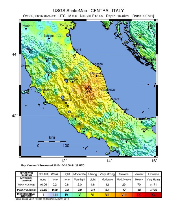
Պատկեր:Shakemap Earthquake 30 Oct 2016 Italy.jpg
Նախադիտման չափ՝ 510 × 599 պիքսել։ Այլ թույլտվությաններ: 204 × 240 պիքսել | 612 × 719 պիքսել.
Սկզբնական նիշք (612 × 719 փիքսել, նիշքի չափը՝ 124 ԿԲ, MIME-տեսակը՝ image/jpeg)
Ամփոփում
| Նկարագրում | |
| Թվական | |
| Աղբյուր | https://earthquake.usgs.gov/earthquakes/eventpage/us1000731j#shakemap |
| Հեղինակ | United States Geological Survey |
Արտոնագրում
This image is in the public domain in the United States because it only contains materials that originally came from the United States Geological Survey, an agency of the United States Department of the Interior. For more information, see the official USGS copyright policy.
|
Նիշքի պատմություն
Մատնահարեք օրվան/ժամին՝ նիշքի այդ պահին տեսքը դիտելու համար։
| Օր/Ժամ | Մանրապատկեր | Օբյեկտի չափը | Մասնակից | Մեկնաբանություն | |
|---|---|---|---|---|---|
| ընթացիկ | 17:03, 30 Հոկտեմբերի 2016 | | 612 × 719 (124 ԿԲ) | Nick.mon | User created page with UploadWizard |
Նիշքի օգտագործում
Հետևյալ էջը հղվում է այս նիշքին՝
Նիշքի համընդհանուր օգտագործում
Հետևյալ այլ վիքիները օգտագործում են այս նիշքը՝
- Օգտագործումը ar.wikipedia.org կայքում
- Օգտագործումը azb.wikipedia.org կայքում
- Օգտագործումը ca.wikipedia.org կայքում
- Օգտագործումը en.wikipedia.org կայքում
- Օգտագործումը fa.wikipedia.org կայքում
- Օգտագործումը fr.wikipedia.org կայքում
- Օգտագործումը it.wikipedia.org կայքում
- Օգտագործումը ko.wikipedia.org կայքում
- Օգտագործումը lt.wikipedia.org կայքում
- Օգտագործումը nl.wikipedia.org կայքում
- Օգտագործումը pt.wikipedia.org կայքում
- Օգտագործումը ro.wikipedia.org կայքում
- Օգտագործումը www.wikidata.org կայքում