Պատկեր:Scramble-for-Africa-1880-1913-v2.png
Նախադիտման չափ՝ 800 × 396 պիքսել։ Այլ թույլտվությաններ: 320 × 159 պիքսել | 640 × 317 պիքսել | 1024 × 508 պիքսել | 1280 × 634 պիքսել | 2280 × 1130 պիքսել.
Սկզբնական նիշք (2280 × 1130 փիքսել, նիշքի չափը՝ 258 ԿԲ, MIME-տեսակը՝ image/png)

|
This map image could be re-created using vector graphics as an SVG file. This has several advantages; see Commons:Media for cleanup for more information. If an SVG form of this image is available, please upload it and afterwards replace this template with
{{vector version available|new image name}}.
It is recommended to name the SVG file “Scramble-for-Africa-1880-1913-v2.svg”—then the template Vector version available (or Vva) does not need the new image name parameter. |
Ամփոփում
| Նկարագրում |
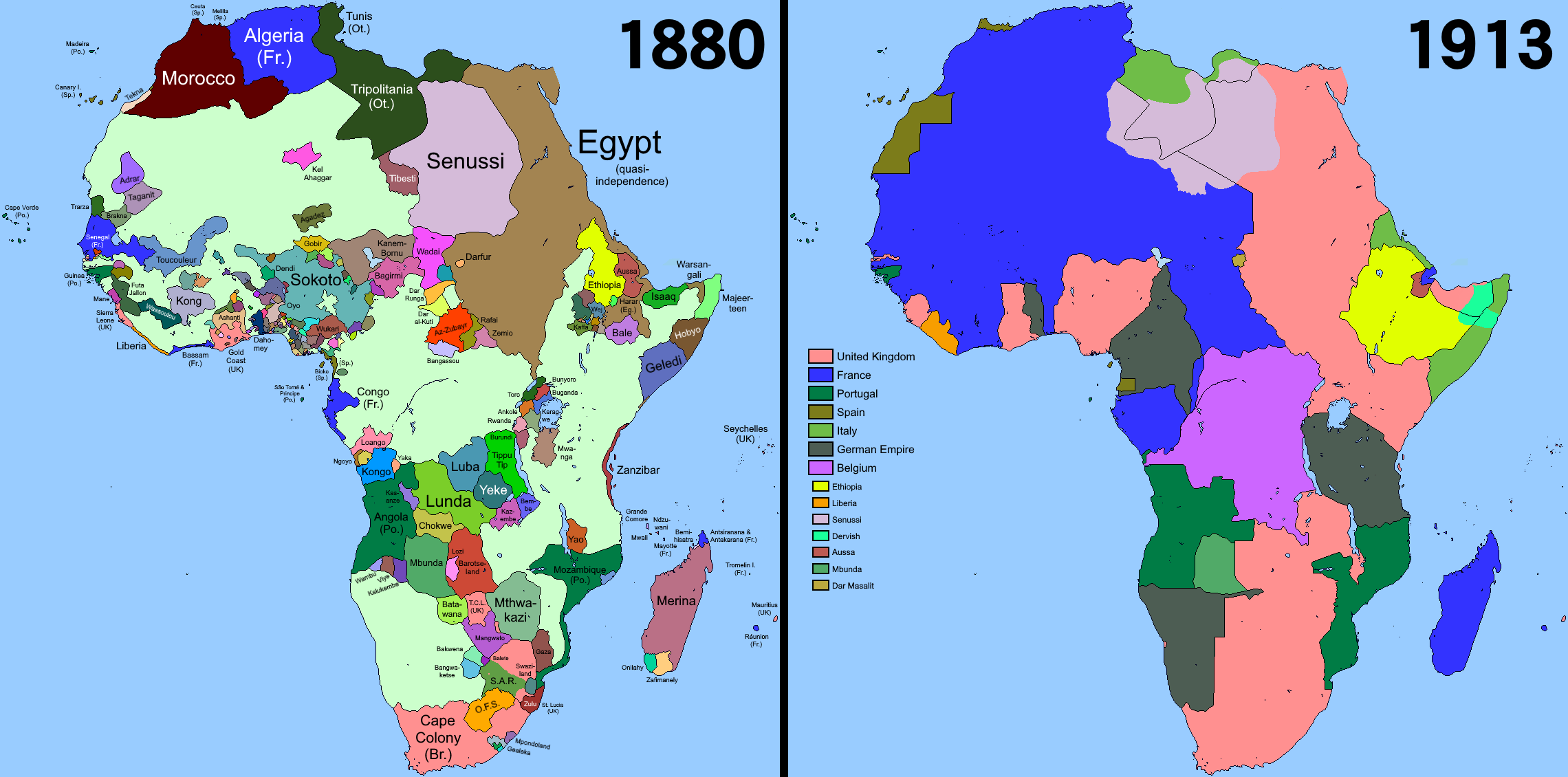
English: Comparison of Africa in the years 1880 and 1913. Shows how the Scramble for Africa affected the continent. Uses Qazaq2007's QBAM map from alternatehistory.com. Various sources used, including Wikipedia itself. Version 1: https://commons.wikimedia.org/wiki/File:Scramble-for-Africa-1880-1913.png |
| Թվական | |
| Աղբյուր | Բեռնողի սեփական աշխատանք |
| Հեղինակ | Somebody500 |
Արտոնագրում
Ես, սույն աշխատանքի հեղինակային իրավունքների տերը, այսուհետ այն հրատարակում եմ հետևյալ արտոնագրի ներքո։
This file is licensed under the Creative Commons Attribution-Share Alike 4.0 International license.
- Դուք ազատ եք՝
- կիսվել ստեղծագործությամբ – պատճենել, տարածել և փոխանցել այս աշխատանքը։
- վերափոխել – ադապտացնել աշխատանքը
- Պահպանելով հետևյալ պայմանները'
- հղում – Դուք պետք է նշեք հեղինակի (իրավատիրոջ) հղումը:
- համանման տարածում – Եթե դուք ձևափոխում եք, փոխակերպում, կամ այս աշխատանքի հիման վրա ստեղծում եք նոր աշխատանք, ապա ձեր ստեղծածը կարող է տարածվել միայն նույն կամ համարժեք թույլատրագրով։
Նիշքի պատմություն
Մատնահարեք օրվան/ժամին՝ նիշքի այդ պահին տեսքը դիտելու համար։
| Օր/Ժամ | Մանրապատկեր | Օբյեկտի չափը | Մասնակից | Մեկնաբանություն | |
|---|---|---|---|---|---|
| ընթացիկ | 18:31, 4 Օգոստոսի 2023 | | 2280 × 1130 (258 ԿԲ) | Somebody500 | |
| 19:13, 6 Մայիսի 2023 |  | 2280 × 1130 (273 ԿԲ) | Randomastwritter | The King's African Rifles - Volume 2 - Page 421 Moyse-Bartlett · 2012, "nearest dervish post was now at Jidali"; see jidali geolocation https://mapcarta.com/12458212 | |
| 01:54, 6 Մայիսի 2023 |  | 2280 × 1130 (257 ԿԲ) | Somebody500 | Mossi changes | |
| 23:51, 4 Մայիսի 2023 |  | 2280 × 1130 (274 ԿԲ) | Randomastwritter | per source references at https://commons.wikimedia.org/wiki/File:Daraawiish_state_1900s,_Dervish_state_1900s.png | |
| 21:55, 10 հունվարի 2023 |  | 2280 × 1130 (257 ԿԲ) | Somebody500 | Barotseland caption fix | |
| 21:22, 10 հունվարի 2023 |  | 2280 × 1130 (257 ԿԲ) | Somebody500 | toucouleur rework, +senussi,dervish for 1913 among other hotfixes | |
| 03:31, 20 Հուլիսի 2022 |  | 2280 × 1130 (255 ԿԲ) | Gebagebo | Added Isaaq | |
| 23:26, 24 հունվարի 2022 |  | 2280 × 1130 (269 ԿԲ) | Randomastwritter | added Jubaland | |
| 07:49, 10 Հունիսի 2021 |  | 2280 × 1130 (253 ԿԲ) | Somebody500 | . | |
| 02:10, 19 փետրվարի 2021 |  | 2280 × 1130 (252 ԿԲ) | Somebody500 | . |
Նիշքի օգտագործում
Հետևյալ էջը հղվում է այս նիշքին՝
Նիշքի համընդհանուր օգտագործում
Հետևյալ այլ վիքիները օգտագործում են այս նիշքը՝
- Օգտագործումը ast.wikipedia.org կայքում
- Օգտագործումը az.wikipedia.org կայքում
- Օգտագործումը cs.wikipedia.org կայքում
- Օգտագործումը en.wikipedia.org կայքում
- Colonialism
- Dahomey
- Guinea-Bissau
- History of Guinea-Bissau
- Atlantic slave trade
- New Imperialism
- Berlin Conference
- Christianization
- Decolonisation of Africa
- European exploration of Africa
- Analysis of European colonialism and colonization
- Africa
- List of national border changes (1815–1914)
- Expansionism
- Colonisation of Africa
- Political history of the world
- 19th century
- Settler colonialism
- Detribalization
- Medieval and early modern Africa
- User:Falcaorib/Africa
- Օգտագործումը es.wikipedia.org կայքում
- Օգտագործումը eu.wikipedia.org կայքում
- Օգտագործումը fr.wikipedia.org կայքում
- Օգտագործումը ha.wikipedia.org կայքում
- Օգտագործումը hu.wikipedia.org կայքում
- Օգտագործումը io.wikipedia.org կայքում
- Օգտագործումը mk.wikipedia.org կայքում
- Օգտագործումը pt.wikipedia.org կայքում
- Օգտագործումը ro.wikipedia.org կայքում
- Օգտագործումը ru.wikipedia.org կայքում
- Օգտագործումը sd.wikipedia.org կայքում
- Օգտագործումը si.wikipedia.org կայքում
- Օգտագործումը sw.wikipedia.org կայքում
- Օգտագործումը th.wikipedia.org կայքում
- Օգտագործումը tum.wikipedia.org կայքում
- Օգտագործումը vi.wikipedia.org կայքում