Պատկեր:Nansen Franz Josef Land voyage map.svg

Size of this PNG preview of this SVG file: 600 × 438 պիքսել. Այլ թույլտվությաններ: 320 × 234 պիքսել | 640 × 467 պիքսել | 1024 × 748 պիքսել | 1280 × 934 պիքսել | 2560 × 1869 պիքսել.
Սկզբնական նիշք (SVG-նիշք, անվանապես 600 × 438 փիքսել, նիշքի չափը՝ 400 ԿԲ)
Ամփոփում
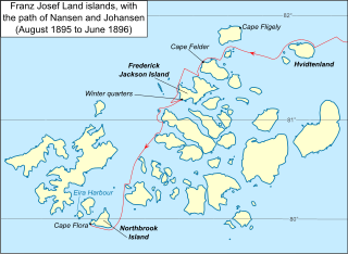
| Նկարագրում | Map of Franz Josef Land archipelago in the Arctic Ocean north of Russia, showing the path of Nansen and Johansen through the islands, August 1895 to June 1896 |
| Թվական | |
| Աղբյուր |
Vector version of File:Nansen Franz Josef Land Voyage Map.PNG Սա վեկտոր գրաֆիկական պատկեր է ստեղծված է եղել Inkscape օգնությամբ: . |
| Հեղինակ | Dtbohrer |
| Այլ մեկնակերպներ |
Derivative works of this file: Nansen Franz Josef Land voyage map-fr.svg PNG version |
Արտոնագրում
| I, the copyright holder of this work, release this work into the public domain. This applies worldwide. In some countries this may not be legally possible; if so: I grant anyone the right to use this work for any purpose, without any conditions, unless such conditions are required by law. |
Նիշքի պատմություն
Մատնահարեք օրվան/ժամին՝ նիշքի այդ պահին տեսքը դիտելու համար։
| Օր/Ժամ | Մանրապատկեր | Օբյեկտի չափը | Մասնակից | Մեկնաբանություն | |
|---|---|---|---|---|---|
| ընթացիկ | 23:17, 17 Հոկտեմբերի 2009 | | 600 × 438 (400 ԿԲ) | Niagara | darken latitude lines |
| 01:33, 13 Հոկտեմբերի 2009 |  | 600 × 438 (401 ԿԲ) | Niagara | == Summary == {{Information |Description = Map of Franz Josef Land archipelago in the Arctic Ocean north of Russia, showing the path of Nansen and Johansen through the islands, August 1895 to June 189 |
Նիշքի օգտագործում
Հետևյալ էջը հղվում է այս նիշքին՝
Նիշքի համընդհանուր օգտագործում
Հետևյալ այլ վիքիները օգտագործում են այս նիշքը՝
- Օգտագործումը ar.wikipedia.org կայքում
- Օգտագործումը ast.wikipedia.org կայքում
- Օգտագործումը be.wikipedia.org կայքում
- Օգտագործումը ca.wikipedia.org կայքում
- Օգտագործումը en.wikipedia.org կայքում
- Օգտագործումը es.wikipedia.org կայքում
- Օգտագործումը fr.wikipedia.org կայքում
- Օգտագործումը it.wikipedia.org կայքում
- Օգտագործումը ja.wikipedia.org կայքում
- Օգտագործումը pt.wikipedia.org կայքում
- Օգտագործումը ro.wikipedia.org կայքում
- Օգտագործումը zh.wikipedia.org կայքում