Պատկեր:Mount Rainier 5917s.JPG

Նախադիտման չափ՝ 709 × 600 պիքսել։ Այլ թույլտվությաններ: 284 × 240 պիքսել | 567 × 480 պիքսել | 908 × 768 պիքսել | 1210 × 1024 պիքսել | 2420 × 2048 պիքսել | 4920 × 4163 պիքսել.
Սկզբնական նիշք (4920 × 4163 փիքսել, նիշքի չափը՝ 4,95 ՄԲ, MIME-տեսակը՝ image/jpeg)
| Նկարագրում |
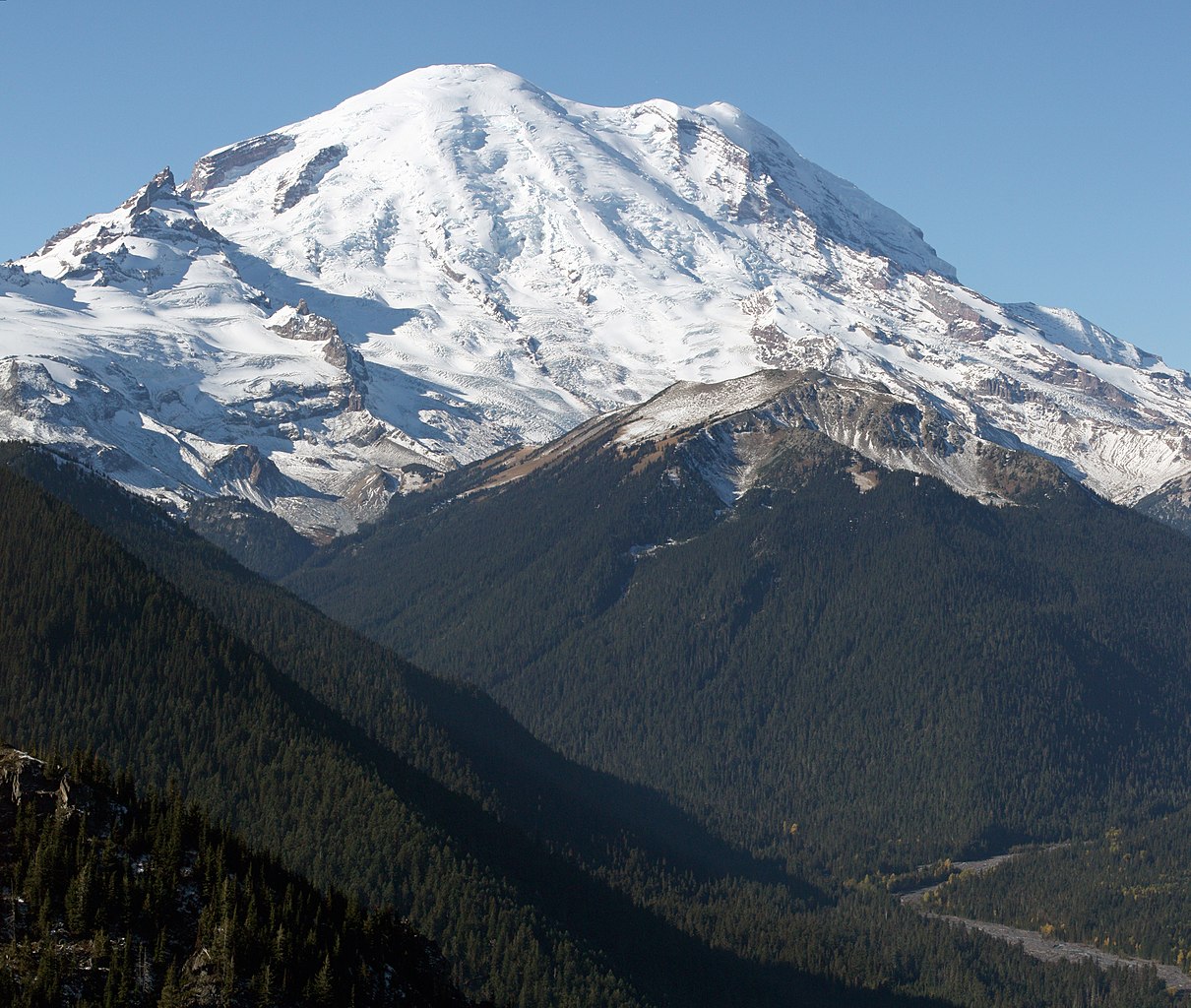
English: Mount Rainier with its main summit, Columbia Crest (14410 feet) at the center. Emmons Glacier covers most of the visible flank of the mountain. Ingraham Glacier (left) is between Gibraltar Rock (12660 feet) high on the left skyline and Disappointment Cleaver. Left of Gibraltar Rock is sharp pointed Little Tahoma (11138 feet) with Frying Pan Glacier on its flank. It is the source of Frying Pan Creek in the valley left of forested and rounded Goat Island Mountain, in front of the Emmons Glacier. Liberty Cap (14112 feet) is visible on the right center skyline behind Russell Cliff. Curtis Ridge descends to the right from Russell Cliff. Winthrop Glacier flows right below Curtis Ridge and behind shallow Steamboat Prow (9680 feet) with the small Inter Glacier on its northeast face. The White River comes from the Emmons Glacier and flows around the right side of Goat Island Mountain in the watercourse visible below right.
Esperanto: monto Rainier vidata de oriento |
| Թվական | 22 Հոկտեմբեր 2008, 11:19:11 −07:00 |
| Աղբյուր | Բեռնողի սեփական աշխատանք |
| Հեղինակ | Walter Siegmund (talk) |
| Այլ մեկնակերպներ |
|


| Տեսախցիկի տեղագրություն | | Այս և ուրիշ պատկերներ իրենց տեղագրությամբ OpenStreetMap |
|---|
- Location source: Garmin GPSmap 60CSx
- Location Datum: WGS84
- Viewpoint location: Crystal Lakes Trail, Mount Rainier National Park
- Viewpoint elevation: 1732 meter (5684 ft)
- View direction: West-southwest
- Camera: Canon EOS DIGITAL REBEL XSi
- Exposure Time: 1/800
- F Number: f/11.0
- Focal Length: 70.0
- ISO Speed Rating: 400
| Սա խմբագրված պատկեր է, որը համեմատ բնօրինակին ենթարկվել է թվային մշակման։ Փոփոխությունները՝ Stitched two images; adjusted levels and color balance; please see other versions in the information template for the originals: Խմբագրել է Wsiegmund մասնակիցը։
|
©2009 Walter Siegmund
Արտոնագրում
Ես, այս աշխատանքի հեղինակային իրավունքների տերը, ներկա հրատարակում եմ սրա հետևյալ լիցենզիաների պայմաններով

|
Այս վավերագրման պատճենահանման, տարածման և/կամ ձևափոխման թույլտվություն կամ լիցենզիայի GNU FDL պայմաններով 1.2 մեկնակերպի կամ ավելի ուշ, հրատարակված Ազատ ծրագրային ապահովության հիմնադրամում, առանց անփոփոխելի հատվածների, առանց բնագիրների, որոնք տեղադրված են առաջին և վերջին շապիկներում: Լիցենզիայի պատճենը գտնվում է GNU Free Documentation License հատվածում: |
This file is licensed under the Creative Commons Attribution-Share Alike 3.0 Unported, 2.5 Generic, 2.0 Generic and 1.0 Generic license.
- Դուք ազատ եք՝
- կիսվել ստեղծագործությամբ – պատճենել, տարածել և փոխանցել այս աշխատանքը։
- վերափոխել – ադապտացնել աշխատանքը
- Պահպանելով հետևյալ պայմանները'
- հղում – Դուք պետք է նշեք հեղինակի (իրավատիրոջ) հղումը:
- համանման տարածում – Եթե դուք ձևափոխում եք, փոխակերպում, կամ այս աշխատանքի հիման վրա ստեղծում եք նոր աշխատանք, ապա ձեր ստեղծածը կարող է տարածվել միայն նույն կամ համարժեք թույլատրագրով։
Կարող եք ընտրել այս թույլատրագրերից ցանկացածը։
Նիշքի պատմություն
Մատնահարեք օրվան/ժամին՝ նիշքի այդ պահին տեսքը դիտելու համար։
| Օր/Ժամ | Մանրապատկեր | Օբյեկտի չափը | Մասնակից | Մեկնաբանություն | |
|---|---|---|---|---|---|
| ընթացիկ | 05:27, 21 Մարտի 2009 | | 4920 × 4163 (4,95 ՄԲ) | Wsiegmund | Removed dust spots |
| 04:22, 13 Մարտի 2009 |  | 4920 × 4163 (4,95 ՄԲ) | Wsiegmund | {{Information |Description = {{en|Mount Rainier with its main summit, Columbia Crest (14410 feet) at the center. Emmons Glacier covers most of the visible flank of the mountain. Ingraham Glacier (left) is between Gibraltar Rock (12660 feet) high on th |
Նիշքի օգտագործում
Այս նիշքին օգտագործող էջեր չկան։
Նիշքի համընդհանուր օգտագործում
Հետևյալ այլ վիքիները օգտագործում են այս նիշքը՝
- Օգտագործումը ar.wikipedia.org կայքում
- Օգտագործումը arz.wikipedia.org կայքում
- Օգտագործումը bn.wikipedia.org կայքում
- Օգտագործումը ca.wikipedia.org կայքում
- Օգտագործումը ceb.wikipedia.org կայքում
- Օգտագործումը cs.wikipedia.org կայքում
- Օգտագործումը de.wikipedia.org կայքում
- Օգտագործումը el.wikipedia.org կայքում
- Օգտագործումը en.wikipedia.org կայքում
- Pacific Northwest
- Dixy Lee Ray
- List of mountain peaks of North America
- List of National Historic Landmarks in Washington (state)
- List of the most isolated major summits of the United States
- Talk:Mount Rainier/Archive 1
- User talk:Hike395/Archive 10
- List of ultras of North America
- List of the most prominent summits of the United States
- List of the major 100-kilometer summits of North America
- Wikipedia:Teahouse/Guest book/Archive 1
- User:Ecpiandy/Washington (state)
- List of the highest major summits of North America
- List of the highest major summits of the United States
- Օգտագործումը en.wikiversity.org կայքում
- Օգտագործումը en.wikivoyage.org կայքում
- Օգտագործումը eo.wikipedia.org կայքում
- Օգտագործումը es.wikipedia.org կայքում
- Օգտագործումը es.wikivoyage.org կայքում
- Օգտագործումը et.wikipedia.org կայքում
- Օգտագործումը eu.wikipedia.org կայքում
- Օգտագործումը frr.wikipedia.org կայքում
- Օգտագործումը fr.wikipedia.org կայքում
- Mont Saint Helens
- Mont Rainier
- Mont Shasta
- Chaîne des Cascades
- Mont Hood
- Mont Adams
- Mont Baker
- Pic Glacier
- Three Sisters (Oregon)
- Pic Lassen
- Medicine Lake (volcan)
- Portail:États-Unis/Articles de qualité
- Mont Washington (Oregon)
- Wikipédia:Lumière sur/Mai 2008
- Wikipédia:Lumière sur/Mont Rainier
- Wikipédia:Sélection/Géographie
- Wikipédia:Sélection/Volcanisme
- Mont Thielsen
Տեսնել այս նիշքի ավելի համընդհանուր օգտագործումը: