Պատկեր:Mexico cartel map May 2010.svg

Size of this PNG preview of this SVG file: 800 × 544 պիքսել. Այլ թույլտվությաններ: 320 × 218 պիքսել | 640 × 435 պիքսել | 1024 × 696 պիքսել | 1280 × 870 պիքսել | 2560 × 1741 պիքսել | 1000 × 680 պիքսել.
Սկզբնական նիշք (SVG-նիշք, անվանապես 1000 × 680 փիքսել, նիշքի չափը՝ 193 ԿԲ)
| Նկարագրում |
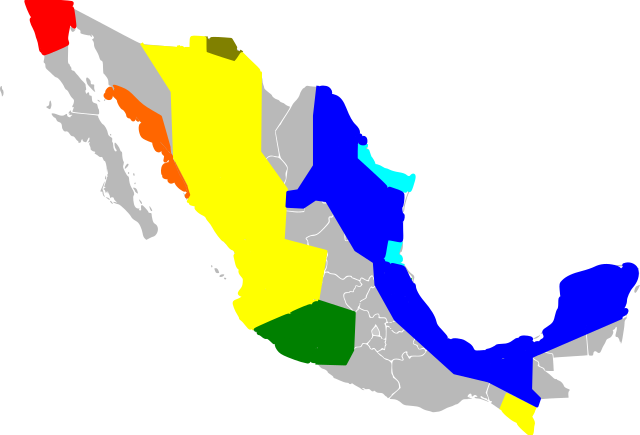
English: An approximate map of the areas held by various Mexican cartels. This map was generated using the information at [1], based on [2] (STRATFOR report dated May 17, 2010). Some points from that map were roughly located and used to draw line segments, from which the territories were filled. Note that the method of simply sampling individual location datapoints from a map precludes all possibility of copyright, and my experience trying to control Inkscape was so poor I feel like I couldn't violate copyright with it if I wanted to! Red = Tijuana/Arellano Felix, Orange = Beltran Leyva, Yellow=Sinaloa, Green=La Familia/Michoacan, Brown=Carillo Fuentes, Cyan=Gulf Cartel/New Federation, Blue=Zetas. Note that this data was likely never very reliable, has been further degraded by my method of redrawing the map, and is surely out of date as of the time I uploaded it. Last but not least, be warned this Inkscape monstrosity may not act like proper svg and could end up not displaying the way it did on my screen. |
| Թվական | (UTC) |
| Աղբյուր | |
| Հեղինակ |
|
![[1]](http://www.wickenburg-az.com/wp-content/uploads/2010/11/Smuggling_1-4.jpg)
Ես, այս աշխատանքի հեղինակային իրավունքների տերը, ներկա հրատարակում եմ սրա հետևյալ լիցենզիաների պայմաններով
Այս նիշքը հասանելի է Creative Commons Attribution-Share Alike 3.0 Unported արտոնագրի ներքո:
- Դուք ազատ եք՝
- կիսվել ստեղծագործությամբ – պատճենել, տարածել և փոխանցել այս աշխատանքը։
- վերափոխել – ադապտացնել աշխատանքը
- Պահպանելով հետևյալ պայմանները'
- հղում – Դուք պետք է նշեք հեղինակի (իրավատիրոջ) հղումը:
- համանման տարածում – Եթե դուք ձևափոխում եք, փոխակերպում, կամ այս աշխատանքի հիման վրա ստեղծում եք նոր աշխատանք, ապա ձեր ստեղծածը կարող է տարածվել միայն նույն կամ համարժեք թույլատրագրով։

|
Այս վավերագրման պատճենահանման, տարածման և/կամ ձևափոխման թույլտվություն կամ լիցենզիայի GNU FDL պայմաններով 1.2 մեկնակերպի կամ ավելի ուշ, հրատարակված Ազատ ծրագրային ապահովության հիմնադրամում, առանց անփոփոխելի հատվածների, առանց բնագիրների, որոնք տեղադրված են առաջին և վերջին շապիկներում: Լիցենզիայի պատճենը գտնվում է GNU Free Documentation License հատվածում: |
Կարող եք ընտրել այս թույլատրագրերից ցանկացածը։
Original upload log
This image is a derivative work of the following images:
- File:Mexico_Map.svg licensed with Cc-by-sa-3.0, GFDL
- 2009-04-27T09:22:54Z Allstrak 1000x680 (151067 Bytes) {{Information |Description={{en|1=a gray map of the states of Mexico to use as template for other Maps}} {{nl|1=een grijze kaart van de staten van Mexico om te gebruiken als 'template' om ander kaarten op te bazeren}} |Source
Uploaded with derivativeFX
Նիշքի պատմություն
Մատնահարեք օրվան/ժամին՝ նիշքի այդ պահին տեսքը դիտելու համար։
| Օր/Ժամ | Մանրապատկեր | Օբյեկտի չափը | Մասնակից | Մեկնաբանություն | |
|---|---|---|---|---|---|
| ընթացիկ | 09:03, 21 Մարտի 2011 | | 1000 × 680 (193 ԿԲ) | Wnt | {{Information |Description={{en|1=An approximate map of the areas held by various Mexican cartels. This map was generated using the information at [http://www.wickenburg-az.com/wp-content/uploads/2010/11/Smuggling_1-4.jpg], based on [http://www.stratfor. |
Նիշքի օգտագործում
Հետևյալ էջը հղվում է այս նիշքին՝
Նիշքի համընդհանուր օգտագործում
Հետևյալ այլ վիքիները օգտագործում են այս նիշքը՝
- Օգտագործումը af.wikipedia.org կայքում
- Օգտագործումը ast.wikipedia.org կայքում
- Օգտագործումը cs.wikipedia.org կայքում
- Օգտագործումը en.wikipedia.org կայքում
- Օգտագործումը es.wikipedia.org կայքում
- Օգտագործումը eu.wikipedia.org կայքում
- Օգտագործումը it.wikipedia.org կայքում
- Օգտագործումը ja.wikipedia.org կայքում
- Օգտագործումը ka.wikipedia.org կայքում
- Օգտագործումը ko.wikipedia.org կայքում
- Օգտագործումը pl.wikipedia.org կայքում
- Օգտագործումը ro.wikipedia.org կայքում
- Օգտագործումը ru.wikipedia.org կայքում
- Օգտագործումը ru.wikinews.org կայքում
- Օգտագործումը sk.wikipedia.org կայքում
- Օգտագործումը sr.wikipedia.org կայքում
- Օգտագործումը tr.wikipedia.org կայքում
- Օգտագործումը uk.wikipedia.org կայքում