Պատկեր:Mapa Argentina Tipos clima IGN.jpg

Սկզբնական նիշք (2148 × 3253 փիքսել, նիշքի չափը՝ 1,25 ՄԲ, MIME-տեսակը՝ image/jpeg)
Ամփոփում
| Նկարագրում |
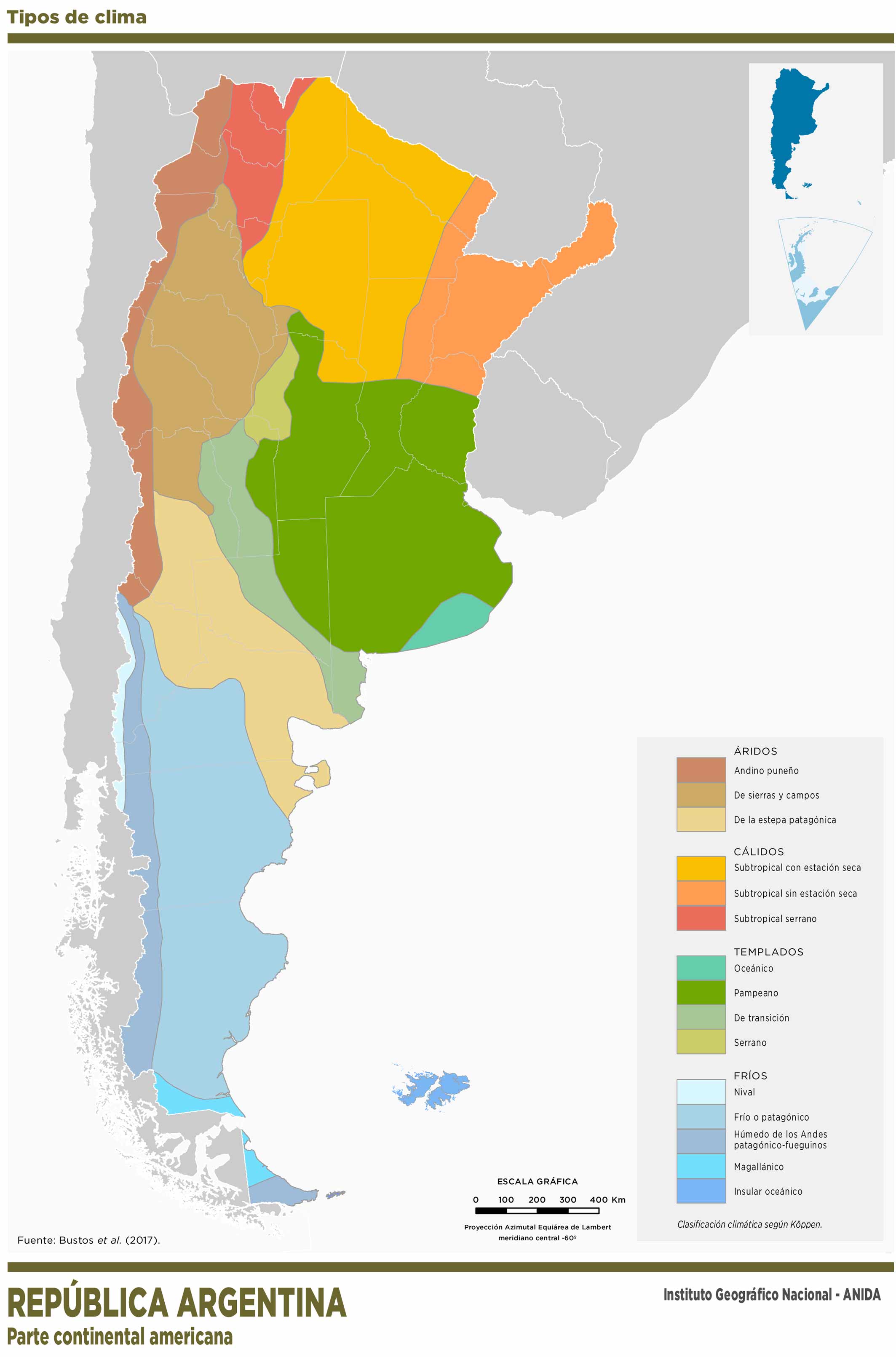
Español: Tipos de clima
Se presenta el mapa del cono sur de América del Sur, con la parte sudamericana de la República Argentina coloreada según los tipos climáticos considerados por el autor. A continuación se trascribe la referencia principal y se nombran los colores entre paréntesis ÁRIDOS (marrones) Andino puneño De sierras y campos De la estepa patagónica. CÁLIDOS Subtropical sin estación seca (amarillo) Subtropical con estación seca (naranja) Subtropical serrano (rojo) TEMPLADOS (verdes) Oceánico Pampeano De transición Serrano FRÍOS (azules) Nival Frío o patagónico Húmedo de los Andes patagónico-fueguinos, Magallánico Insular oceánico En el mapa se muestran los países limítrofes en gris y los limites internacionales en blanco. Se muestras los limites inter-provinciales argentinos en gris. Leyendas inferiores: Proyección azimutal equiárea de Lambert. Meridiano central: -60º Fuente: Bustos et al. (2017) República Argentina Parte continental americana Institutriz Geográfico Nacional - ANIDA En la esquina superior derecha hay un recuadro con un mapa que muestra el cono sur de marica y un sector de la Antártida con el territorio argentino resaltado en azul y la Antártida Argentina en celeste.English: Types of weather
The map of the southern cone of South America is presented, with the South American part of the Argentine Republic colored according to the climatic types considered by the author. The main reference is transcribed below and the colors are named in parentheses ARID (brown) Andean Puno Of mountains and fields From the Patagonian steppe. WARM Subtropical without dry season (yellow) Subtropical with dry season (orange) Serrano subtropical (red) TEMPERED (green) Oceanic Pampeano Of Transition Highlander COLD (blue) Snowy Cold or Patagonian Wet from the Patagonian-Fuegian Andes, Magellanic Oceanic island The map shows the bordering countries in gray and the international borders in white. Argentine inter-provincial boundaries are shown in gray. Lower legends: Lambert equiazial azimuth projection. Central meridian: -60º Source: Bustos et al. (2017) Argentinian republic American mainland National Geographic Institute - ANIDA In the upper right corner there is a box with a map showing the southern cone of fag and a sector of Antarctica with the Argentine territory highlighted in blue and the Argentine Antarctica in light blue. |
| Թվական | |
| Աղբյուր |
Instituto Geográfico Nacional de la República Argentina. Atlas Nacional Interactivo de Argentina (ANIdA) http://anida.ign.gob.ar/index.html Clima de Argentina https://ide.ign.gob.ar/portal/apps/MapJournal/index.html?appid=b58d8b8841ef472e962317cac879e87f Enlace al mapa: http://static.ign.gob.ar/anida/fisico1/clima/m_arg_c_tiposclima_300_v1.jpg Enlace a los Términos y Condiciones de Uso deñ material IGN: https://www.ign.gob.ar/descargas/tyc3.html |
| Հեղինակ | Instituto Geográfico Nacional de la República Argentina. |
Արտոնագրում
- Դուք ազատ եք՝
- կիսվել ստեղծագործությամբ – պատճենել, տարածել և փոխանցել այս աշխատանքը։
- վերափոխել – ադապտացնել աշխատանքը
- Պահպանելով հետևյալ պայմանները'
- հղում – Դուք պետք է նշեք հեղինակի (իրավատիրոջ) հղումը:
- համանման տարածում – Եթե դուք ձևափոխում եք, փոխակերպում, կամ այս աշխատանքի հիման վրա ստեղծում եք նոր աշխատանք, ապա ձեր ստեղծածը կարող է տարածվել միայն նույն կամ համարժեք թույլատրագրով։
Նիշքի պատմություն
Մատնահարեք օրվան/ժամին՝ նիշքի այդ պահին տեսքը դիտելու համար։
| Օր/Ժամ | Մանրապատկեր | Օբյեկտի չափը | Մասնակից | Մեկնաբանություն | |
|---|---|---|---|---|---|
| ընթացիկ | 17:34, 28 Մայիսի 2020 | | 2148 × 3253 (1,25 ՄԲ) | JPLema | Uploaded a work by Instituto Geográfico Nacional de la República Argentina. from Instituto Geográfico Nacional de la República Argentina. Atlas Nacional Interactivo de Argentina (ANIdA) http://anida.ign.gob.ar/index.html Clima de Argentina https://ide.ign.gob.ar/portal/apps/MapJournal/index.html?appid=b58d8b8841ef472e962317cac879e87f Enlace al mapa: http://static.ign.gob.ar/anida/fisico1/clima/m_arg_c_tiposclima_300_v1.jpg with UploadWizard |
Նիշքի օգտագործում
Հետևյալ էջը հղվում է այս նիշքին՝
Նիշքի համընդհանուր օգտագործում
Հետևյալ այլ վիքիները օգտագործում են այս նիշքը՝
- Օգտագործումը en.wikipedia.org կայքում
- Օգտագործումը es.wikipedia.org կայքում