Պատկեր:Map of Rhode Island NA.png
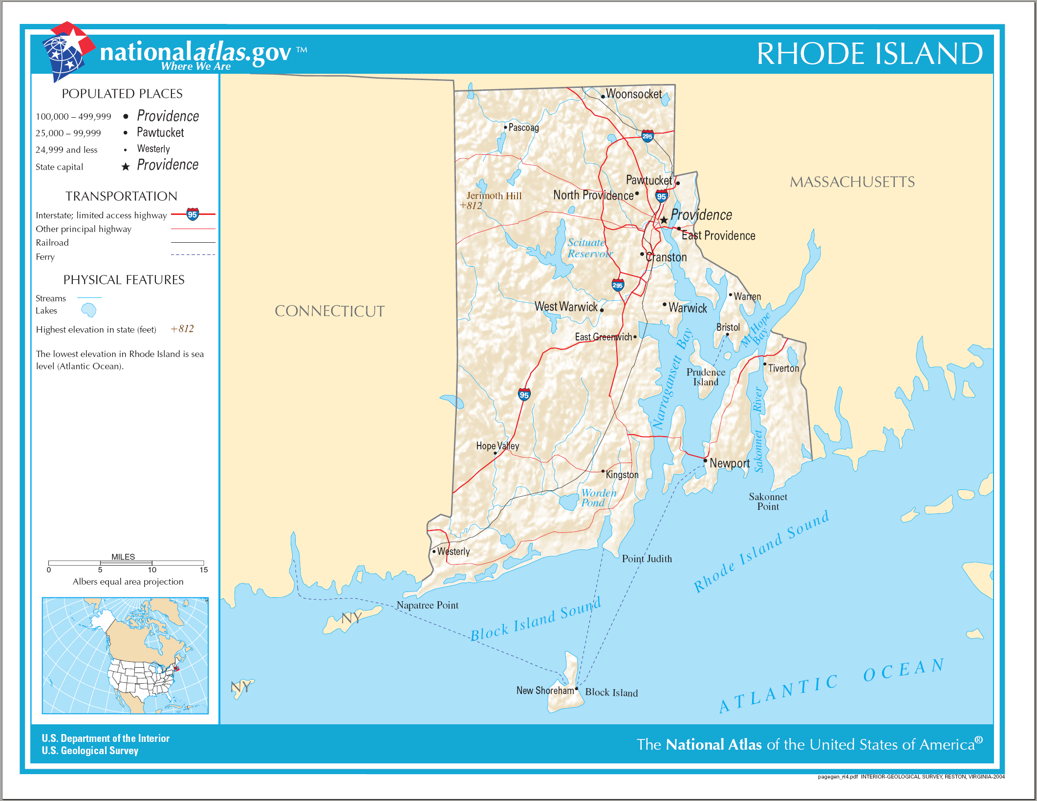
Նախադիտման չափ՝ 776 × 600 պիքսել։ Այլ թույլտվությաններ: 311 × 240 պիքսել | 621 × 480 պիքսել | 994 × 768 պիքսել | 1280 × 989 պիքսել | 2122 × 1640 պիքսել.
Սկզբնական նիշք (2122 × 1640 փիքսել, նիշքի չափը՝ 822 ԿԲ, MIME-տեսակը՝ image/png)
Ամփոփում
| Նկարագրում |
English: National Atlas map of Rhode Island. |
| Թվական | |
| Աղբյուր | National Atlas |
| Հեղինակ |
Արտոնագրում
This map was obtained from an edition of the National Atlas of the United States. Like almost all works of the U.S. federal government, works from the National Atlas are in the public domain in the United States.
Online access: NationalAtlas.gov | 1970 print edition: Library of Congress, Perry-Castañeda Library
|
Նիշքի պատմություն
Մատնահարեք օրվան/ժամին՝ նիշքի այդ պահին տեսքը դիտելու համար։
| Օր/Ժամ | Մանրապատկեր | Օբյեկտի չափը | Մասնակից | Մեկնաբանություն | |
|---|---|---|---|---|---|
| ընթացիկ | 14:16, 17 Ապրիլի 2015 | | 2122 × 1640 (822 ԿԲ) | RokerHRO | optipng -o7 -i0 → 18.34% decrease |
| 08:22, 15 Օգոստոսի 2006 |  | 2122 × 1640 (1007 ԿԲ) | Huebi~commonswiki | {{Information| |Description=Map of Rhode Island |Source=[http://www.nationalatlas.gov National Atlas] }} Category:Maps of the United States Category:Maps of Rhode Island {{PD-USGov-Atlas}} |
Նիշքի օգտագործում
Հետևյալ էջը հղվում է այս նիշքին՝
Նիշքի համընդհանուր օգտագործում
Հետևյալ այլ վիքիները օգտագործում են այս նիշքը՝
- Օգտագործումը ang.wikipedia.org կայքում
- Օգտագործումը be.wikipedia.org կայքում
- Օգտագործումը ca.wikipedia.org կայքում
- Օգտագործումը de.wikipedia.org կայքում
- Օգտագործումը en.wikipedia.org կայքում
- Օգտագործումը fi.wikipedia.org կայքում
- Օգտագործումը ga.wikipedia.org կայքում
- Օգտագործումը gl.wikipedia.org կայքում
- Օգտագործումը hu.wikipedia.org կայքում
- Օգտագործումը ja.wikipedia.org կայքում
- Օգտագործումը ko.wikipedia.org կայքում
- Օգտագործումը lt.wikipedia.org կայքում
- Օգտագործումը mhr.wikipedia.org կայքում
- Օգտագործումը mr.wikipedia.org կայքում
- Օգտագործումը os.wikipedia.org կայքում
- Օգտագործումը sw.wikipedia.org կայքում
- Օգտագործումը tg.wikipedia.org կայքում
- Օգտագործումը tt.wikipedia.org կայքում
- Օգտագործումը www.wikidata.org կայքում
- Օգտագործումը zea.wikipedia.org կայքում