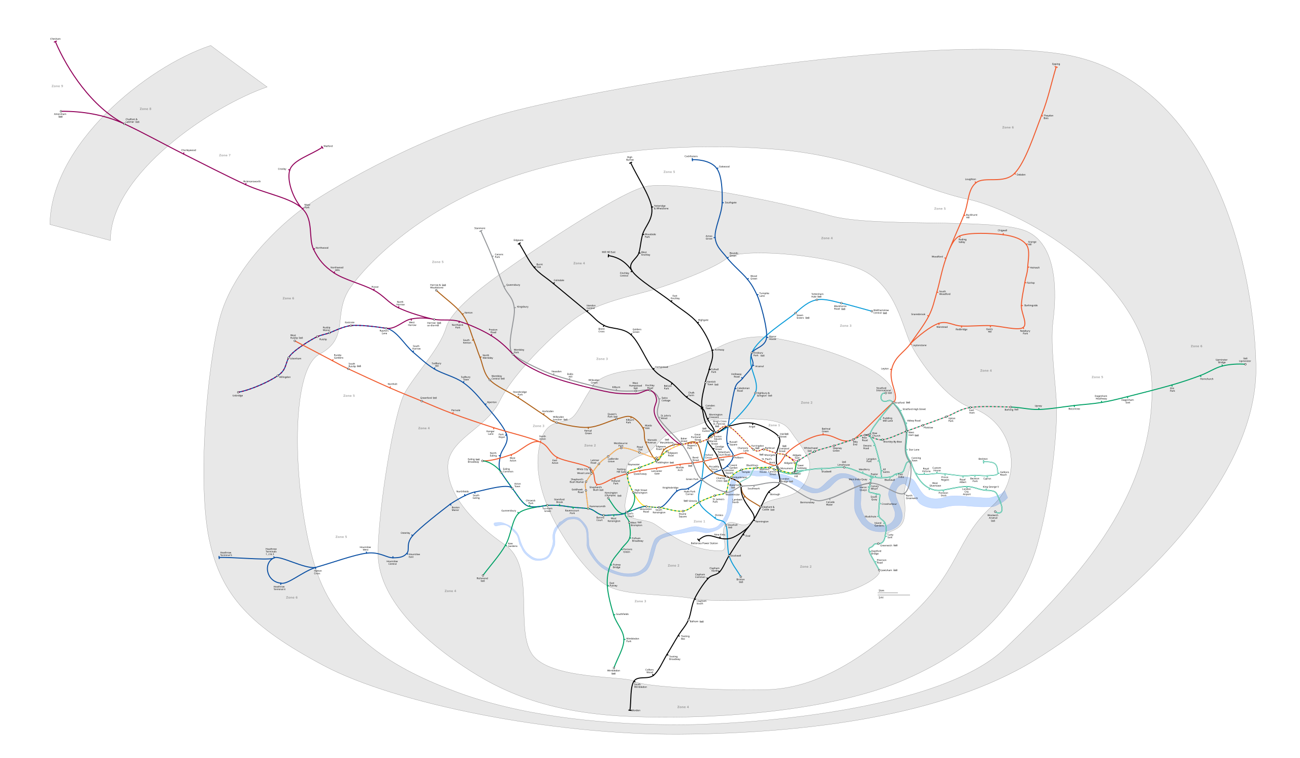
Պատկեր:London Underground full map.svg

Size of this PNG preview of this SVG file: 800 × 467 պիքսել. Այլ թույլտվությաններ: 320 × 187 պիքսել | 640 × 373 պիքսել | 1024 × 597 պիքսել | 1280 × 747 պիքսել | 2560 × 1493 պիքսել | 6000 × 3500 պիքսել.
Սկզբնական նիշք (SVG-նիշք, անվանապես 6000 × 3500 փիքսել, նիշքի չափը՝ 239 ԿԲ)
| Նկարագրում | Geographic Map of the London Underground showing all stations with travelcard zones indicated | ||||||||
| Թվական | (UTC) | ||||||||
| Աղբյուր | |||||||||
| Հեղինակ |
|
||||||||
| Իրավունքներ (Նիշքի վերաօգտագործումը) |
Ես, այս աշխատանքի հեղինակային իրավունքների տերը, ներկա հրատարակում եմ սրա հետևյալ լիցենզիաների պայմաններով This file is licensed under the Creative Commons Attribution-Share Alike 2.5 Generic, 2.0 Generic and 1.0 Generic license.
Կարող եք ընտրել այս թույլատրագրերից ցանկացածը։ |
||||||||
| Այլ մեկնակերպներ |
PNG version: File:London Underground full map.png File:SW Chinese Map of the London Underground.svg |

Original upload log
This image is a derivative work of the following images:
- File:London_Underground_full_map.svg licensed with Cc-by-sa-2.5,2.0,1.0, GFDL
- 2009-05-31T00:05:06Z DavidCane 1000x570 (292205 Bytes) Stations added (in non visible section of map): Wood Lane, Woolwich Arsenal, Langdon Park. Station renamed: Shepherd' Bush to Shepherd's Bush Market
- 2009-04-07T12:50:10Z Ed g2s 1000x570 (287789 Bytes) remove external file references
- 2009-04-07T12:47:04Z Ed g2s 1000x570 (289202 Bytes) {{Information |Description={{en|1=London Underground map}} |Source=Own work by uploader |Author=[[User:Ed g2s|Ed g2s]] |Date= |Permission= |other_versions= }}
Uploaded with derivativeFX
Նիշքի պատմություն
Մատնահարեք օրվան/ժամին՝ նիշքի այդ պահին տեսքը դիտելու համար։
| Օր/Ժամ | Մանրապատկեր | Օբյեկտի չափը | Մասնակից | Մեկնաբանություն | |
|---|---|---|---|---|---|
| ընթացիկ | 17:50, 24 Մայիսի 2023 | | 6000 × 3500 (239 ԿԲ) | NordNordWest | corr |
| 17:34, 24 Մայիսի 2023 |  | 6000 × 3500 (239 ԿԲ) | NordNordWest | several updates | |
| 20:14, 20 Հուլիսի 2020 |  | 6000 × 3500 (237 ԿԲ) | Hx7 | Move Zone 3 text out of Zone 2 area in East London | |
| 13:02, 20 Հուլիսի 2020 |  | 6000 × 3500 (237 ԿԲ) | Hx7 | Boundary corrections - Woolwich Arsenal is in Zone 4, not Zone 3 | |
| 22:16, 4 փետրվարի 2018 |  | 6000 × 3500 (237 ԿԲ) | DavidCane | Alter zone 2 boundary to reflect the dual-zone status of DLR stations on the Stratford branch. | |
| 03:15, 12 Օգոստոսի 2014 |  | 6000 × 3500 (187 ԿԲ) | Jc86035 | Added Stratford Intl extension from File:DOcklands Light Railway.svg, also added geographically accurate paths from that image, and linked together paths and set IDs | |
| 10:33, 8 Օգոստոսի 2014 |  | 6000 × 3500 (189 ԿԲ) | Jc86035 | Fixed Edgware Road stations (now unlinked). Thanks to User:Sameboat for finding the error | |
| 03:36, 8 Մարտի 2014 |  | 6000 × 3500 (186 ԿԲ) | Jc86035 | Compressed using SVGCleaner | |
| 12:42, 3 Դեկտեմբերի 2013 |  | 6000 × 3500 (257 ԿԲ) | Jc86035 | Better aligned Waterloo & City line | |
| 10:47, 3 Դեկտեմբերի 2013 |  | 6000 × 3500 (256 ԿԲ) | Jc86035 | Fixed a large amount of issues; see London Underground geographic maps#To do |
Նիշքի օգտագործում
Հետևյալ էջը հղվում է այս նիշքին՝
Նիշքի համընդհանուր օգտագործում
Հետևյալ այլ վիքիները օգտագործում են այս նիշքը՝
- Օգտագործումը ar.wikipedia.org կայքում
- Օգտագործումը da.wikipedia.org կայքում
- Օգտագործումը de.wikipedia.org կայքում
- Օգտագործումը en.wikipedia.org կայքում
- Օգտագործումը et.wikipedia.org կայքում
- Օգտագործումը fr.wikipedia.org կայքում
- Métro de Londres
- Woodside Park (métro de Londres)
- High Barnet (métro de Londres)
- Totteridge & Whetstone (métro de Londres)
- Morden (métro de Londres)
- Burnt Oak (métro de Londres)
- West Finchley (métro de Londres)
- Brent Cross (métro de Londres)
- Golders Green (métro de Londres)
- Finchley Central (métro de Londres)
- Colliers Wood (métro de Londres)
- Stratford (métro de Londres)
- Mill Hill East (métro de Londres)
- Edgware (métro de Londres)
- Balham (métro de Londres)
- Barking (métro de Londres)
- Colindale (métro de Londres)
- Hendon Central (métro de Londres)
- Kilburn Park (métro de Londres)
- Willesden Junction (métro de Londres)
- Alperton (métro de Londres)
- Sudbury Town (métro de Londres)
- Wimbledon Park (métro de Londres)
- Becontree (métro de Londres)
- Upney (métro de Londres)
- Dagenham Heathway (métro de Londres)
- Dagenham East (métro de Londres)
- Canning Town (métro de Londres)
- Kilburn (métro de Londres)
- Willesden Green (métro de Londres)
- Dollis Hill (métro de Londres)
- Neasden (métro de Londres)
- Wembley Park (métro de Londres)
- Kingsbury (métro de Londres)
- Queensbury (métro de Londres)
- Northwick Park (métro de Londres)
- Preston Road (métro de Londres)
- East Finchley (métro de Londres)
Տեսնել այս նիշքի ավելի համընդհանուր օգտագործումը: