La_Grande_Riviere_carte_2.png(522 × 390 փիքսել, նիշքի չափը՝ 43 ԿԲ, MIME-տեսակը՝ image/png)

Այս նիշքը տեղադրված է Վիքիպահեստում է և այն կարող է օգտագործվել այլ նախագծերի կողմից։ Վիքիպահեստում նիշքի մասին տեղեկությունների հիմնական մասը ներկայացված է ստորև։

Նկարագրում
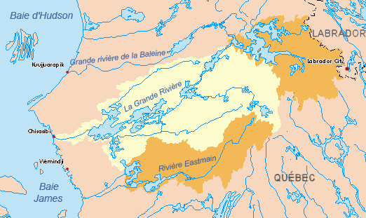
Français : Le bassin versant de La Grande Rivière. En orange, les deux grandes dérivations réalisées dans le cadre du projet de la Baie James. Au nord-est, les travaux de dérivation de la rivière Caniapiscau; au sud, la dérivation EOL (Eastmain, Opinaca, La Grande), qui alimente directement le réservoir Robert-Bourassa. Mis à jour pour 2010.
English: The La Grande River basin. In orange, the two main river diversions engineered as part of the James Bay Project. Northeast, the Caniapiscau River; south, the EOL (Eastmain, Opinaca, La Grande), feeds the Robert-Bourassa reservoir. Updated as of 2010.
Թվական (UTC)
Աղբյուր
Հեղինակ
Այլ մեկնակերպներ (pre-2010).
Սա խմբագրված պատկեր է, որը համեմատ բնօրինակին ենթարկվել է թվային մշակման։ Փոփոխությունները՝ {{{1}}}: Սկզբնական պատկերը գտնվում է այստեղ՝ La Grande map 2.png։

Ես, սույն աշխատանքի հեղինակային իրավունքների տերը, այսուհետ այն հրատարակում եմ հետևյալ արտոնագրի ներքո։
Public domain I, the copyright holder of this work, release this work into the public domain. This applies worldwide.
In some countries this may not be legally possible; if so:
I grant anyone the right to use this work for any purpose, without any conditions, unless such conditions are required by law.

Original upload log

This image is a derivative work of the following images:

  • File:La_Grande_map_2.png licensed with PD-self
    • 2010-06-10T01:55:14Z P199 522x390 (37514 Bytes) {{Information |Description={{en|1=Drainage basin of the La Grande River, Quebec, Canada. Updated for 2010. For prior to 2010, see '''[[:File:La_Grande_map.png]]'''.*Yellow = original basin*Orange = diverted basins into the La

Uploaded with derivativeFX

Captions

Add a one-line explanation of what this file represents

Items portrayed in this file

պատկերված

28 Հուլիսի 2010

Նիշքի պատմություն

Մատնահարեք օրվան/ժամին՝ նիշքի այդ պահին տեսքը դիտելու համար։

Օր/ԺամՄանրապատկերՕբյեկտի չափըՄասնակիցՄեկնաբանություն
ընթացիկ22:55, 28 Հուլիսի 201022:55, 28 Հուլիսի 2010 տարբերակի մանրապատկերը522 × 390 (43 ԿԲ)Piotron{{Information |Description={{fr|1=Bassin versant de la Grande Rivière (Québec, Canada). Mis à jour pour 2010. Voyez '''File:La_Grande_Riviere_carte.png''' pour la version avant de 2010. *Jaune = bassin original *Orange = bassins détournés vers

Հետևյալ էջը հղվում է այս նիշքին՝

Նիշքի համընդհանուր օգտագործում

Հետևյալ այլ վիքիները օգտագործում են այս նիշքը՝