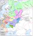
Պատկեր:Kievan Rus in 1237 (en).svg

Size of this PNG preview of this SVG file: 553 × 600 պիքսել. Այլ թույլտվությաններ: 221 × 240 պիքսել | 442 × 480 պիքսել | 708 × 768 պիքսել | 944 × 1024 պիքսել | 1888 × 2048 պիքսել | 1204 × 1306 պիքսել.
Սկզբնական նիշք (SVG-նիշք, անվանապես 1204 × 1306 փիքսել, նիշքի չափը՝ 332 ԿԲ)
Նիշքի պատմություն
Մատնահարեք օրվան/ժամին՝ նիշքի այդ պահին տեսքը դիտելու համար։
| Օր/Ժամ | Մանրապատկեր | Օբյեկտի չափը | Մասնակից | Մեկնաբանություն | |
|---|---|---|---|---|---|
| ընթացիկ | 08:06, 25 Սեպտեմբերի 2021 |  | 1204 × 1306 (332 ԿԲ) | Veverve | "Khvalisy" changed to to "Khvalis" |
| 19:16, 9 Ապրիլի 2021 |  | 1204 × 1306 (360 ԿԲ) | Veverve | "Principalty of Vladimir-Suzdal" corrected to "Principality of Vladimir-Suzdal" | |
| 17:04, 16 Մայիսի 2020 |  | 1204 × 1306 (360 ԿԲ) | Goran tek-en | Named changed as requested by user:Veverve | |
| 17:39, 12 փետրվարի 2020 |  | 1204 × 1306 (318 ԿԲ) | Goran tek-en | Changed name of Vladimir as requested bu Veverve | |
| 16:59, 12 փետրվարի 2020 |  | 1204 × 1306 (317 ԿԲ) | Goran tek-en | {{Information |description ={{en|1=Map of the Kievan Rus in 1237. The nales of tribes and peoples are in brown, the names of countries outside the Kievan Rus are in black. The names of principalties of the Kievan Rus are in blue; if a principalty bears the a name which comes directly from the name of its capital (e.g. the Principalty of Kiev), the complete name of the paincipalty is not on the map and the capital name is in blue.}} |date =20200212 |source ={{Own}}<br>... |
Նիշքի օգտագործում
Հետևյալ էջը հղվում է այս նիշքին՝
Նիշքի համընդհանուր օգտագործում
Հետևյալ այլ վիքիները օգտագործում են այս նիշքը՝
- Օգտագործումը be.wikipedia.org կայքում
- Օգտագործումը bg.wikipedia.org կայքում
- Օգտագործումը ca.wikipedia.org կայքում
- Օգտագործումը cy.wikipedia.org կայքում
- Օգտագործումը da.wikipedia.org կայքում
- Օգտագործումը de.wikipedia.org կայքում
- Օգտագործումը en.wikipedia.org կայքում
- Օգտագործումը es.wikipedia.org կայքում
- Օգտագործումը it.wikipedia.org կայքում
- Օգտագործումը ja.wikipedia.org կայքում
- Օգտագործումը ko.wikipedia.org կայքում
- Օգտագործումը la.wikipedia.org կայքում
- Օգտագործումը nl.wikipedia.org կայքում
- Օգտագործումը nn.wikipedia.org կայքում
- Օգտագործումը no.wikipedia.org կայքում
- Օգտագործումը pt.wikipedia.org կայքում
- Օգտագործումը ro.wikipedia.org կայքում
- Օգտագործումը rue.wikipedia.org կայքում
- Օգտագործումը sw.wikipedia.org կայքում
- Օգտագործումը tt.wikipedia.org կայքում
- Օգտագործումը uk.wikipedia.org կայքում
- Օգտագործումը www.wikidata.org կայքում

