Պատկեր:Juba map.jpg
Ավելի բարձր կետաչափով տարբերակ չկա։
Juba_map.jpg (519 × 533 փիքսել, նիշքի չափը՝ 67 ԿԲ, MIME-տեսակը՝ image/jpeg)
| Նկարագրում |
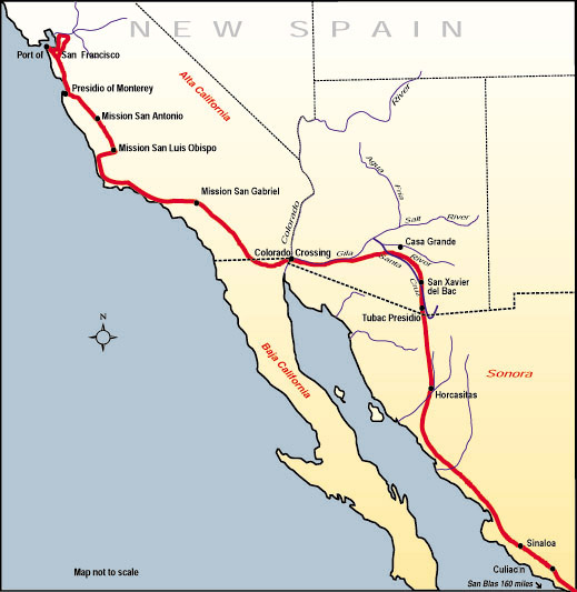
English: Map of the route, Juan Bautista de Anza travelled in 1775-76 from Mexico to todays San Francisco, where he founded the Presidio of San Francisco. Español: Mapa de la ruta que Juan Bautista de Anza recorrió en 1775-76 desde México hasta la actual San Francisco, donde fundó el Presidio de San Francisco. |
|||
| Աղբյուր | http://www.nps.gov/juba | |||
| Հեղինակ | ||||
| Իրավունքներ (Նիշքի վերաօգտագործումը) |
|
Նիշքի պատմություն
Մատնահարեք օրվան/ժամին՝ նիշքի այդ պահին տեսքը դիտելու համար։
| Օր/Ժամ | Մանրապատկեր | Օբյեկտի չափը | Մասնակից | Մեկնաբանություն | |
|---|---|---|---|---|---|
| ընթացիկ | 20:53, 10 Հուլիսի 2006 | | 519 × 533 (67 ԿԲ) | H-stt | {{Information |Description= Map of the route, Juan Bautista de Anza travelled in 1775-76 from Baja California to todays San Francisco, where he founded the Presidio of San Francisco |Source= http://www.nps.gov/juba |Date= |Author= |Permission= {{PD-USGov |
Նիշքի օգտագործում
Հետևյալ էջը հղվում է այս նիշքին՝
Նիշքի համընդհանուր օգտագործում
Հետևյալ այլ վիքիները օգտագործում են այս նիշքը՝
- Օգտագործումը bg.wikipedia.org կայքում
- Օգտագործումը ca.wikipedia.org կայքում
- Օգտագործումը en.wikipedia.org կայքում
- Օգտագործումը es.wikipedia.org կայքում
- Օգտագործումը ja.wikipedia.org կայքում