Պատկեր:John-Tallis-1851-Tibet-Mongolia-and-Manchuria-NE.jpg

Սկզբնական նիշք (2100 × 1400 փիքսել, նիշքի չափը՝ 2,34 ՄԲ, MIME-տեսակը՝ image/jpeg)
| Նկարագրում |
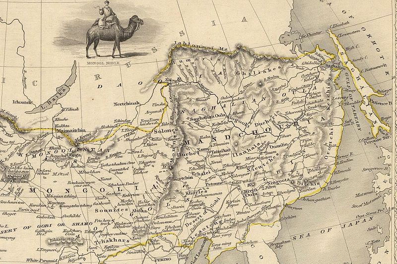
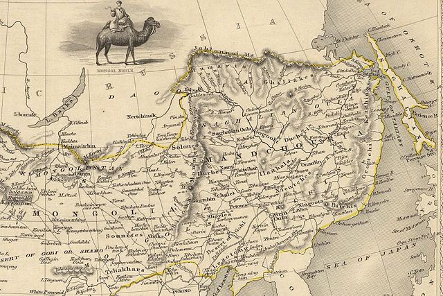
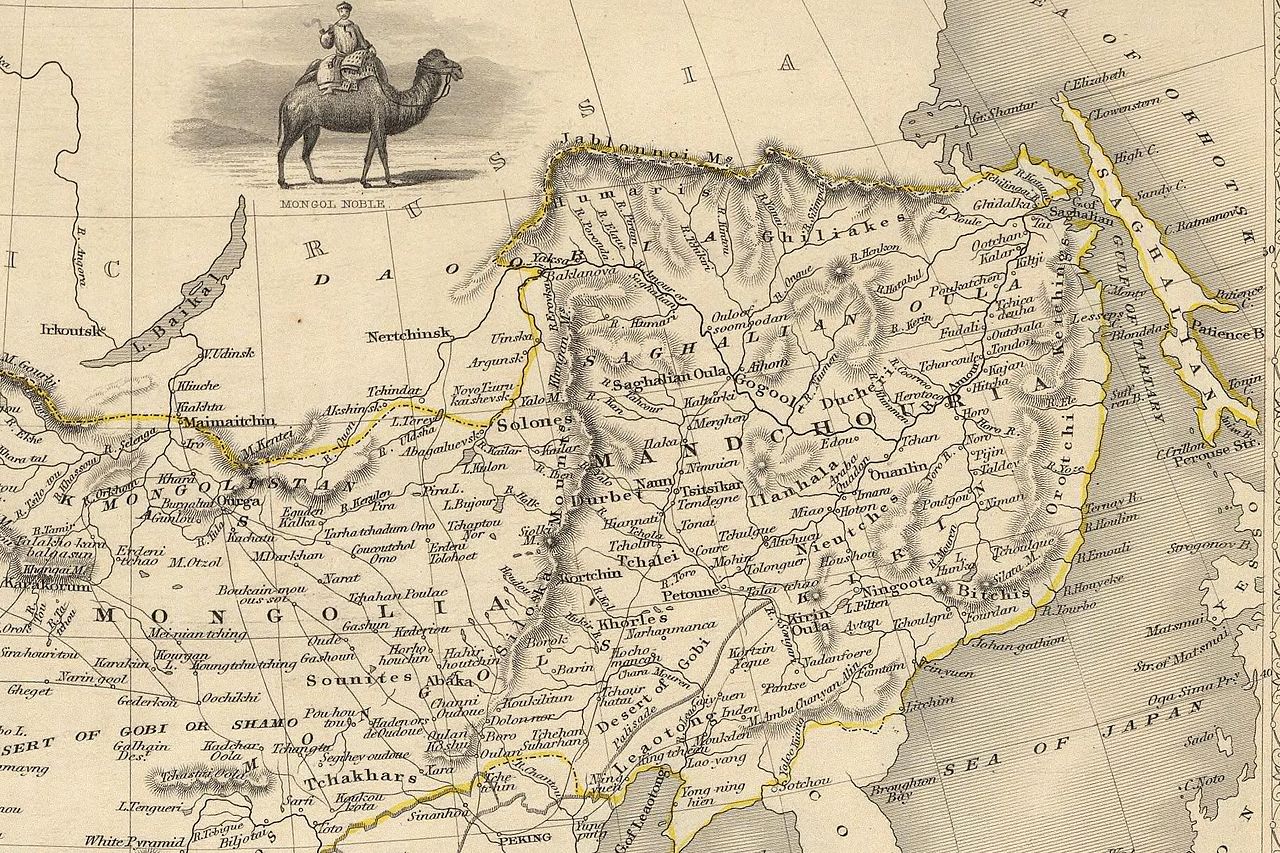
English: The NE section (Manchuria and Mongolia) of the map of the northern and western part of the Chinese Empire - "Thibet, Mongolia, and Mandchouria". The borders are shows as per the 1858 treaty of Aigun. The main Russian center in Transbaikalia is still Nerchinsk, rather than Chita. The outline of Sakhalin is already shown fairly correctly, but the body of water separating it from the mainland is still labeled "Gulf of Tartary" (rather than '"Strait). |
| Թվական | (UTC) |
| Աղբյուր | |
| Հեղինակ |
|
| Այլ մեկնակերպներ |
 |
| Սա խմբագրված պատկեր է, որը համեմատ բնօրինակին ենթարկվել է թվային մշակման։ Փոփոխությունները՝ NE section: Սկզբնական պատկերը գտնվում է այստեղ՝ John-Tallis-1851-Tibet-Mongolia-and-Manchuria-33621.jpg։ Խմբագրել է Vmenkov մասնակիցը։
|
|
This work is in the public domain in its country of origin and other countries and areas where the copyright term is the author's life plus 70 years or fewer.
| |
| This file has been identified as being free of known restrictions under copyright law, including all related and neighboring rights. | |
Original upload log
This image is a derivative work of the following images:
- File:John-Tallis-1851-Tibet-Mongolia-and-Manchuria-33621.jpg licensed with PD-old
- 2009-12-07T02:26:08Z Vmenkov 4700x3750 (4267392 Bytes) better resolution, as available from http://www.davidrumsey.com/luna/servlet/detail/RUMSEY~8~1~821~60126:Thibet,-Mongolia,-and-Mandchouria--
- 2009-12-07T01:38:06Z Vmenkov 1289x989 (395245 Bytes) {{Information |Description={{en|1=Map of the northern and western part of the Chinese Empire - "Thibet, Mongolia, and Mandchouria".
Uploaded with derivativeFX
Նիշքի պատմություն
Մատնահարեք օրվան/ժամին՝ նիշքի այդ պահին տեսքը դիտելու համար։
| Օր/Ժամ | Մանրապատկեր | Օբյեկտի չափը | Մասնակից | Մեկնաբանություն | |
|---|---|---|---|---|---|
| ընթացիկ | 03:10, 7 Դեկտեմբերի 2009 | | 2100 × 1400 (2,34 ՄԲ) | Vmenkov | {{Information |Description={{en|1=The NE section (Manchuria and Mongolia) of the map of the northern and western part of the Chinese Empire - "Thibet, Mongolia, and Mandchouria". The borders are shows as per the 1858 treaty of Aigun. The main Russian cent |
Նիշքի օգտագործում
Հետևյալ էջը հղվում է այս նիշքին՝
Նիշքի համընդհանուր օգտագործում
Հետևյալ այլ վիքիները օգտագործում են այս նիշքը՝
- Օգտագործումը ar.wikipedia.org կայքում
- Օգտագործումը bn.wikipedia.org կայքում
- Օգտագործումը ca.wikipedia.org կայքում
- Օգտագործումը cs.wikipedia.org կայքում
- Օգտագործումը cv.wikipedia.org կայքում
- Օգտագործումը da.wikipedia.org կայքում
- Օգտագործումը de.wikipedia.org կայքում
- Օգտագործումը en.wikipedia.org կայքում
- Օգտագործումը en.wiktionary.org կայքում
- Օգտագործումը eo.wikipedia.org կայքում
- Օգտագործումը es.wikipedia.org կայքում
- Օգտագործումը fi.wikipedia.org կայքում
- Օգտագործումը fr.wikipedia.org կայքում
- Օգտագործումը id.wikipedia.org կայքում
- Օգտագործումը it.wikipedia.org կայքում
- Օգտագործումը ja.wikipedia.org կայքում
- Օգտագործումը ka.wikipedia.org կայքում
- Օգտագործումը kk.wikipedia.org կայքում
- Օգտագործումը ko.wikipedia.org կայքում
- Օգտագործումը la.wikipedia.org կայքում
- Օգտագործումը lt.wikipedia.org կայքում
- Օգտագործումը mn.wikipedia.org կայքում
- Օգտագործումը no.wikipedia.org կայքում
- Օգտագործումը pl.wikipedia.org կայքում
Տեսնել այս նիշքի ավելի համընդհանուր օգտագործումը: