Պատկեր:Hungary topographic map.jpg
Նախադիտման չափ՝ 800 × 549 պիքսել։ Այլ թույլտվությաններ: 320 × 220 պիքսել | 640 × 439 պիքսել | 912 × 626 պիքսել.
Սկզբնական նիշք (912 × 626 փիքսել, նիշքի չափը՝ 75 ԿԲ, MIME-տեսակը՝ image/jpeg)
Ամփոփում
| Նկարագրում |
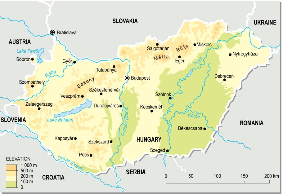
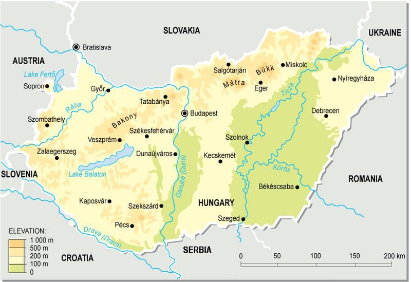
English: Topographic map of Hungary.
Deutsch: Topografische Karte Ungarns. |
| Թվական | |
| Աղբյուր | Բեռնողի սեփական աշխատանք (from a PD map collection. Mistakes fixed) |
| Հեղինակ | Cserlajos |
| Այլ մեկնակերպներ |
|


|
This map has been uploaded by Electionworld from en.wikipedia.org to enable the |


Արտոնագրում
| This work has been released into the public domain by its author, Cserlajos. This applies worldwide. In some countries this may not be legally possible; if so: |
Նիշքի պատմություն
Մատնահարեք օրվան/ժամին՝ նիշքի այդ պահին տեսքը դիտելու համար։
| Օր/Ժամ | Մանրապատկեր | Օբյեկտի չափը | Մասնակից | Մեկնաբանություն | |
|---|---|---|---|---|---|
| ընթացիկ | 23:51, 23 Դեկտեմբերի 2006 | | 912 × 626 (75 ԿԲ) | Electionworld | {{ew|en|Cserlajos}} == Summary == From a pd map collection. Mistakes fixed by User:cserlajos. == Licensing == {{no rights reserved}} |
Նիշքի օգտագործում
Հետևյալ էջը հղվում է այս նիշքին՝
Նիշքի համընդհանուր օգտագործում
Հետևյալ այլ վիքիները օգտագործում են այս նիշքը՝
- Օգտագործումը azb.wikipedia.org կայքում
- Օգտագործումը az.wikipedia.org կայքում
- Օգտագործումը be-tarask.wikipedia.org կայքում
- Օգտագործումը bg.wikipedia.org կայքում
- Օգտագործումը bn.wikipedia.org կայքում
- Օգտագործումը bs.wikipedia.org կայքում
- Օգտագործումը cs.wikipedia.org կայքում
- Օգտագործումը da.wikipedia.org կայքում
- Օգտագործումը de.wikipedia.org կայքում
- Օգտագործումը de.wikibooks.org կայքում
- Օգտագործումը en.wikipedia.org կայքում
- Օգտագործումը eu.wikipedia.org կայքում
- Օգտագործումը fa.wikipedia.org կայքում
- Օգտագործումը fi.wikipedia.org կայքում
- Օգտագործումը fr.wikipedia.org կայքում
- Օգտագործումը gl.wikipedia.org կայքում
- Օգտագործումը gom.wikipedia.org կայքում
- Օգտագործումը he.wikipedia.org կայքում
- Օգտագործումը hr.wikipedia.org կայքում
- Օգտագործումը hr.wiktionary.org կայքում
- Օգտագործումը hu.wikipedia.org կայքում
- Օգտագործումը hu.wikibooks.org կայքում
Տեսնել այս նիշքի ավելի համընդհանուր օգտագործումը: