Պատկեր:Fort Bragg California aerial view.jpg
Նախադիտման չափ՝ 800 × 533 պիքսել։ Այլ թույլտվությաններ: 320 × 213 պիքսել | 640 × 427 պիքսել | 1024 × 683 պիքսել | 1500 × 1000 պիքսել.
Սկզբնական նիշք (1500 × 1000 փիքսել, նիշքի չափը՝ 724 ԿԲ, MIME-տեսակը՝ image/jpeg)
| Նկարագրում |
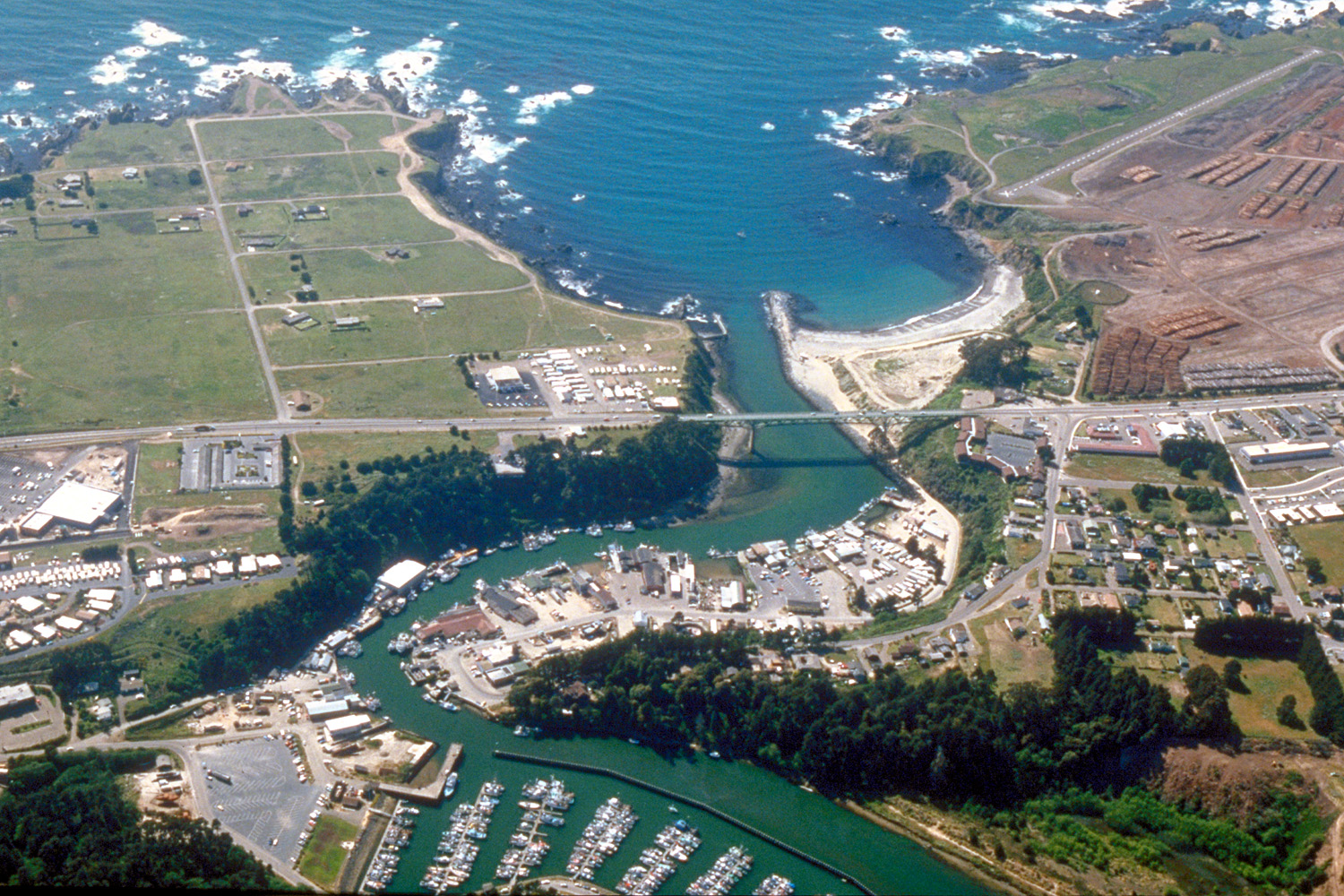
English: Aerial view of the mouth of the Noyo River on the Pacific Ocean at Fort Bragg, Mendocino County, California, USA. California State Route 1 (Main Street in Fort Bragg) crosses the river at the outlet. View is to the west.
Coordinates: 39°25′38.37″N 123°48′24.63″W / 39.427325°N 123.8068417°W |
||
| Թվական | not specified or unknown, 2007 or before, but judging by the view and visual of the photo, it appears to be from the mid-late 1990s. | ||
| Աղբյուր |
U.S. Army Corps of Engineers Digital Visual Library Image page Image description page Digital Visual Library home page |
||
| Հեղինակ | Robert Campbell | ||
| Իրավունքներ (Նիշքի վերաօգտագործումը) |
Այս նիշքը հասանելի է Creative Commons Attribution-Share Alike 3.0 Unported արտոնագրի ներքո:
|
||
| Location | Fort Bragg, Mendocino County, California, USA |

| Տեսախցիկի տեղագրություն | | Այս և ուրիշ պատկերներ իրենց տեղագրությամբ OpenStreetMap |
|---|
Նիշքի պատմություն
Մատնահարեք օրվան/ժամին՝ նիշքի այդ պահին տեսքը դիտելու համար։
| Օր/Ժամ | Մանրապատկեր | Օբյեկտի չափը | Մասնակից | Մեկնաբանություն | |
|---|---|---|---|---|---|
| ընթացիկ | 03:20, 3 Մայիսի 2007 | | 1500 × 1000 (724 ԿԲ) | DanMS | {{Information | Description = {{en|Aerial view of the mouth of the Noyo River on the Pacific Ocean at Fort Bragg, Mendocino County, California, USA. California State Route 1 (Main Street in Fort Bragg) crosses the river at the outlet. View is to the we |
Նիշքի օգտագործում
Հետևյալ էջը հղվում է այս նիշքին՝
Նիշքի համընդհանուր օգտագործում
Հետևյալ այլ վիքիները օգտագործում են այս նիշքը՝
- Օգտագործումը ar.wikipedia.org կայքում
- Օգտագործումը arz.wikipedia.org կայքում
- Օգտագործումը az.wikipedia.org կայքում
- Օգտագործումը be.wikipedia.org կայքում
- Օգտագործումը bg.wikipedia.org կայքում
- Օգտագործումը ca.wikipedia.org կայքում
- Օգտագործումը ceb.wikipedia.org կայքում
- Օգտագործումը ce.wikipedia.org կայքում
- Օգտագործումը cs.wikipedia.org կայքում
- Օգտագործումը cy.wikipedia.org կայքում
- Օգտագործումը de.wikipedia.org կայքում
- Օգտագործումը de.wikivoyage.org կայքում
- Օգտագործումը en.wikipedia.org կայքում
- Օգտագործումը en.wikivoyage.org կայքում
- Օգտագործումը eo.wikipedia.org կայքում
- Օգտագործումը es.wikipedia.org կայքում
- Օգտագործումը eu.wikipedia.org կայքում
- Օգտագործումը fa.wikipedia.org կայքում
- Օգտագործումը fi.wikipedia.org կայքում
- Օգտագործումը fr.wikipedia.org կայքում
- Օգտագործումը ga.wikipedia.org կայքում
- Օգտագործումը gl.wikipedia.org կայքում
- Օգտագործումը he.wikivoyage.org կայքում
- Օգտագործումը ht.wikipedia.org կայքում
- Օգտագործումը hu.wikipedia.org կայքում
- Օգտագործումը it.wikipedia.org կայքում
- Օգտագործումը ko.wikipedia.org կայքում
Տեսնել այս նիշքի ավելի համընդհանուր օգտագործումը: