Պատկեր:East-Hem 700ad.jpg
Սկզբնական նիշք (3240 × 1903 փիքսել, նիշքի չափը՝ 924 ԿԲ, MIME-տեսակը՝ image/jpeg)

|
This historical map image could be re-created using vector graphics as an SVG file. This has several advantages; see Commons:Media for cleanup for more information. If an SVG form of this image is available, please upload it and afterwards replace this template with
{{vector version available|new image name}}.
It is recommended to name the SVG file “East-Hem 700ad.svg”—then the template Vector version available (or Vva) does not need the new image name parameter. |


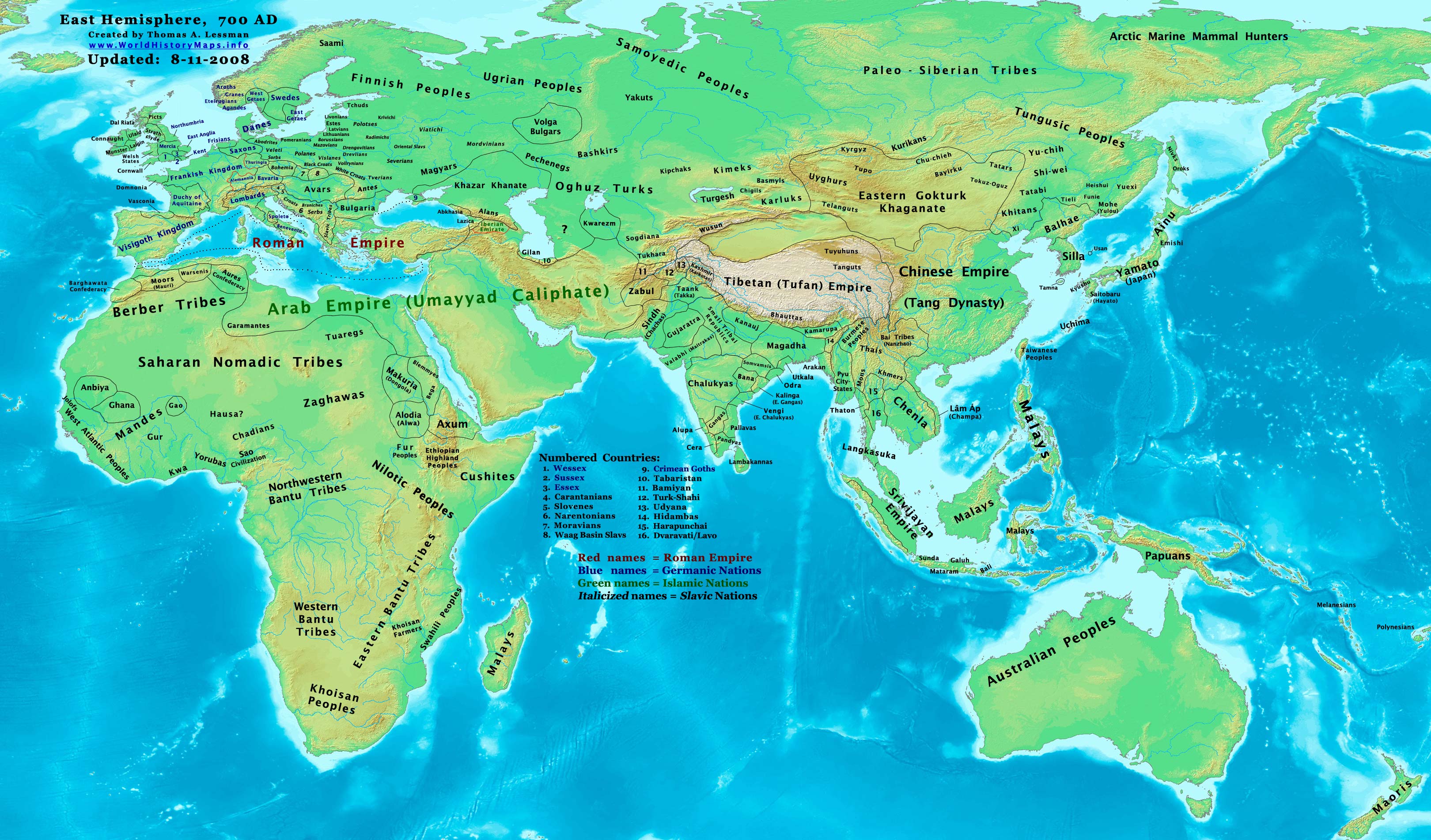
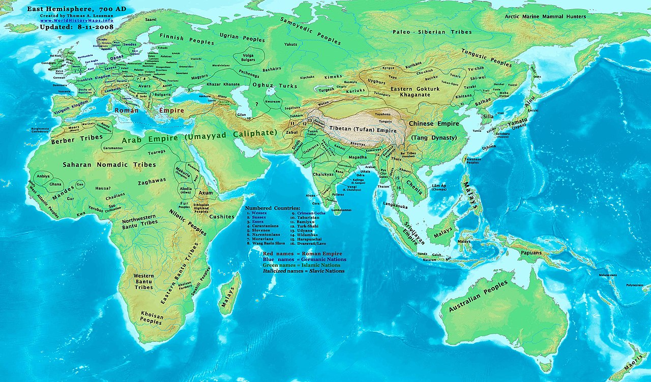
| Նկարագրում | Eastern Hemisphere in 700 AD. |
| Աղբյուր | self-made (For reference information, see the Map Source References section below.) |
| Հեղինակ | Thomas Lessman (Contact!) |
| Իրավունքներ (Նիշքի վերաօգտագործումը) |
Ես, սույն աշխատանքի հեղինակային իրավունքների տերը, այսուհետ այն հրատարակում եմ հետևյալ արտոնագրի ներքո։ Այս նիշքը հասանելի է Creative Commons Attribution-Share Alike 3.0 Unported արտոնագրի ներքո:
|
| Այլ մեկնակերպներ |
Derivative works of this file: Part of East-Hem 700ad.jpg see East-Hem_700ad.jpg file history on Wikipedia. |
Map Summary
Original Source URL: http://www.thomaslessman.com/History/images/East-Hem_700ad.jpg.
This map of the Eastern Hemisphere in 700 AD was created by Thomas Lessman, based on information from the sources listed below. This map is free for educational use (see Permission info above). When using this map, please mention that it is available for free at www.WorldHistoryMaps.info.
Map Source References
- Remember, sources often conflict with each other. This map is only as accurate as the information that is available to me. To report any errors or to help further this work, please click here, or email Thomas Lessman at talessman@yis.us
References for information contained in this map:
1. Borders of Europe are mostly derived from the www.Euratlas.com map of Europe in 700 AD archive copy at the Wayback Machine.
- (Please note: User:Bogomolov.PL has done a great job of showing me possible discrepancies in my north European borders compared to this source, due to the differences in the geographical layout of the maps.)
2. Asian information is mostly derived from the following sources:
- 2a. Wikimedia's World Map 700 CE, created by User:Javierfv1212.
- 2b. Map of Asia in 750 AD, from Huhai.net.
- Please note: borders between Tibet and India are in question due to conflicts between source information:
- 2c. My depiction of Tibet's borders with India are based on these sources:
- 1: DK Atlas of World History (2000 edition, pg. 262), showing Tibet's borders in 800 AD, with northern India (the entire length of the Ganges, almost to the Indus river) under Tibet's control.
- 2: Huhai.net's map of Asia in 750 AD, which shows Tibetan control over Kamarupa, Bengal, and Pala.
- 3: "Himalayan Region, 500–1000 A.D." in Timeline of Art History. New York: The Metropolitan Museum of Art, (October 2001)
- 4: Google Book's "History of Tibet" (Page 54), makes several notes of Nepal's Licchavi dynasty as vassals of Tibet, and also says that India's Pala Empire under King Dharmapala accepted Tibetan overlordship.
- 5: Google Book's "Ancient India", (Page 632), describes Tibetan activities during the reigns of Songtsan Gampo and King Harsha of Kannauj. Also describes the Tibetan subjucation of Kamarupa and Kannauj after the death of King Harsha.
- 6: Wikipedia's article about Tibetan King Songtsän Gampo states that Tibet and Nepal invaded India in 648 AD and defeated Harsha's successor, after the Indian King had attacked a Chinese envoy named Wang Xuanze. (That statement referenced with Stein, R. A. Tibetan Civilization 1962. Revised English edition, 1972, Faber & Faber, London. Reprint, 1972. Stanford University Press, p. 62. ISBN 0-8047-0806-1 cloth; ISBN 0-8047-0901-7 pbk., pp. 58-59)
- Possible alternative borders for Indias Kamarupa, Gauda, Tripura, and Manipur can be seen on User:Porikolpok_Oxom map of Kamarupa 7th-8th Century AD.
3. Fringe areas like Africa, Australia, Siberia, etc. derive from Wikimedia's map of the World Map 700 CE, created by User:Javierfv1212.
4. Much of the information in this map was cross-checked with Bruce Gordon's Regnal Chronologies.
Other Maps by Thomas Lessman
| Maps of the eastern hemisphere showing history
Bold dates are available on Wikimedia or Wikipedia. | ||
| Primeval | ||
| Ancient
|
·| 600 BC | 550 BC | 527 BC | 500 BC |
400 BC | ·| 1 AD | 50 AD | 100 AD | 200 AD | 300 AD | | |
| Medieval |
·| 500 AD | 565 AD | 600 AD | 700 AD | | |
| Modern |
·| 1500 AD | · * For historical maps of the whole world, | |
Նիշքի պատմություն
Մատնահարեք օրվան/ժամին՝ նիշքի այդ պահին տեսքը դիտելու համար։
| Օր/Ժամ | Մանրապատկեր | Օբյեկտի չափը | Մասնակից | Մեկնաբանություն | |
|---|---|---|---|---|---|
| ընթացիկ | 17:42, 13 Հոկտեմբերի 2022 | | 3240 × 1903 (924 ԿԲ) | Gyalu22 | Reverted to version as of 20:11, 11 August 2008 (UTC) This is not an ethnic map. |
| 13:37, 6 Մայիսի 2016 |  | 3240 × 1903 (2,33 ՄԲ) | Julieta39 | Cosmetic changes according with « Putzger historischer Weltatlas Cornelsen » 1990 - ISBN 3-464-00176-8 ; « Atlas historique Georges Duby » Larousse 1987 - ISBN 2-03-503009-9 ; André & Jean Sellier's « Atlas des Peuples » La Découverte : issues... | |
| 20:11, 11 Օգոստոսի 2008 |  | 3240 × 1903 (924 ԿԲ) | Talessman | {{Information |Description= |Source= |Date= |Author= |Permission= |other_versions= }} | |
| 18:37, 9 Մայիսի 2008 |  | 3240 × 1903 (737 ԿԲ) | Talessman | {{Information |Description=Eastern Hemisphere in 700 AD. |Source=self-made |Author=Thomas Lessman |Permission={{self|cc-by-sa-3.0}} }} |
Նիշքի օգտագործում
Նիշքի համընդհանուր օգտագործում
Հետևյալ այլ վիքիները օգտագործում են այս նիշքը՝
- Օգտագործումը ar.wikipedia.org կայքում
- Օգտագործումը arz.wikipedia.org կայքում
- Օգտագործումը azb.wikipedia.org կայքում
- Օգտագործումը be.wikipedia.org կայքում
- Օգտագործումը bs.wikipedia.org կայքում
- Օգտագործումը ca.wikipedia.org կայքում
- Օգտագործումը cs.wikipedia.org կայքում
- Օգտագործումը da.wikipedia.org կայքում
- Օգտագործումը de.wikipedia.org կայքում
- Օգտագործումը en.wikipedia.org կայքում
- 7th century
- 8th century
- 745
- 700
- History of the Khitans
- User:Tompw/sandbox10
- File:Tibet 700ad.jpg
- User:Talessman/Maps
- User talk:Talessman/Maps
- Tibetan Empire
- History of the Great Wall of China
- User:Benjamin Trovato/sandbox
- List of states during the Middle Ages
- List of political entities in the 7th century
- User:Navops47/sandbox10
- Wikipedia:Graphics Lab/Map workshop/Archive/Feb 2018
- User:Falcaorib
- Օգտագործումը es.wikipedia.org կայքում
- Օգտագործումը et.wikipedia.org կայքում
- Օգտագործումը fa.wikipedia.org կայքում
- Օգտագործումը frr.wikipedia.org կայքում
- Օգտագործումը fr.wikipedia.org կայքում
- Օգտագործումը gl.wikipedia.org կայքում
- Օգտագործումը hi.wikipedia.org կայքում
- Օգտագործումը hu.wikipedia.org կայքում
- Օգտագործումը id.wikipedia.org կայքում
- Օգտագործումը it.wikipedia.org կայքում
- Օգտագործումը ja.wikipedia.org կայքում
Տեսնել այս նիշքի ավելի համընդհանուր օգտագործումը: