Clima_de_Chile_fr.png(384 × 404 փիքսել, նիշքի չափը՝ 96 ԿԲ, MIME-տեսակը՝ image/png)

Այս նիշքը տեղադրված է Վիքիպահեստում է և այն կարող է օգտագործվել այլ նախագծերի կողմից։ Վիքիպահեստում նիշքի մասին տեղեկությունների հիմնական մասը ներկայացված է ստորև։

This meteorology image could be re-created using vector graphics as an SVG file. This has several advantages; see Commons:Media for cleanup for more information. If an SVG form of this image is available, please upload it and afterwards replace this template with {{vector version available|new image name}}.


It is recommended to name the SVG file “Clima de Chile fr.svg”—then the template Vector version available (or Vva) does not need the new image name parameter.

Ամփոփում

Նկարագրում
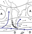
English: Weather maps showing the usual position of weather system around the southern part of South America
.
Français : Carte de surface montrant les systèmes météorologiques affectant habituellement le sud de l'Amérique du Sud
Թվական 12 Հուլիս 2010, 18:43 (UTC)
Աղբյուր
Հեղինակ


Սա խմբագրված պատկեր է, որը համեմատ բնօրինակին ենթարկվել է թվային մշակման։ Փոփոխությունները՝ {{{1}}}: Սկզբնական պատկերը գտնվում է այստեղ՝ Clima de Chile.JPG։ Խմբագրել է Pierre cb մասնակիցը։

Ես, սույն աշխատանքի հեղինակային իրավունքների տերը, այսուհետ այն հրատարակում եմ հետևյալ արտոնագրի ներքո։
Այս պատկերը կամավոր կերպով հանրության սեփականություն է դարձրել սրա հեղինակ, Example, և տեղադրել [[::Main Page| Wikimedia Commons]] նախագծում: Այս թույլտվությունը գործում է ամբողջ աշխարհում:

Եթե դա չի համապատասխանում տվյալ երկրի օրենսդրությունը և անհնար է, ուրեմն՝
Example թույլատվում է այս ֆայլի օգտագործումը տարբեր նպատակներով առանց որևէ պայմանների այնքան, ինչքան թույլատվում է տվյալ երկրի օրենսդրությունը

Original upload log

This image is a derivative work of the following images:

  • File:Clima de Chile.JPG licensed with PD-user-w
    • 2010-07-12T18:33:57Z Pierre cb 384x404 (30838 Bytes) {{Information |Description= Weather maps showing the usual position of weather system around the southern part of South America. |Source= {{Own}} |Date= 2008-02-08 |Author=[[:en:UserDentren|Dentren]] |Permission= {{PD-user-w|

Uploaded with derivativeFX

Captions

Add a one-line explanation of what this file represents

Items portrayed in this file

պատկերված

checksum անգլերեն

9e83deb0981c52db433f77f0359e99943cb9f01d

data size անգլերեն

98 570 Բայթ

404 փիքսել

384 փիքսել

Նիշքի պատմություն

Մատնահարեք օրվան/ժամին՝ նիշքի այդ պահին տեսքը դիտելու համար։

Օր/ԺամՄանրապատկերՕբյեկտի չափըՄասնակիցՄեկնաբանություն
ընթացիկ18:18, 2 Հունիսի 202018:18, 2 Հունիսի 2020 տարբերակի մանրապատկերը384 × 404 (96 ԿԲ)MaulucioniPerou
18:45, 12 Հուլիսի 201018:45, 12 Հուլիսի 2010 տարբերակի մանրապատկերը384 × 404 (80 ԿԲ)Pierre cb{{Information |Description={{en|1=Weather maps showing the usual position of weather system around the southern part of South America}}. {{fr|1=Carte de surface montrant les systèmes météorologiques affectant habituellement le sud de l'Amérique du Sud

Հետևյալ էջը հղվում է այս նիշքին՝

Նիշքի համընդհանուր օգտագործում

Մետատվյալներ