Պատկեր:Bevölkerungsentwicklung Landkreis Potsdam-Mittelmark.pdf

Size of this JPG preview of this PDF file: 800 × 566 պիքսել. Այլ թույլտվությաններ: 320 × 226 պիքսել | 640 × 453 պիքսել | 1024 × 724 պիքսել | 1280 × 905 պիքսել | 1752 × 1239 պիքսել.
Սկզբնական նիշք (1752 × 1239 փիքսել, նիշքի չափը՝ 118 ԿԲ, MIME-տեսակը՝ application/pdf)

|
This graph image could be re-created using vector graphics as an SVG file. This has several advantages; see Commons:Media for cleanup for more information. If an SVG form of this image is available, please upload it and afterwards replace this template with
{{vector version available|new image name}}.
It is recommended to name the SVG file “Bevölkerungsentwicklung Landkreis Potsdam-Mittelmark.svg”—then the template Vector version available (or Vva) does not need the new image name parameter. |
Ամփոփում
| Նկարագրում |
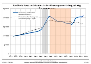
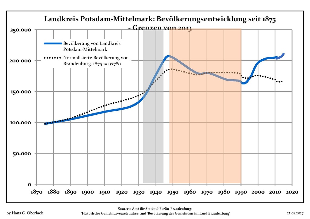
Deutsch: Bevölkerungsentwicklung in den heutigen Grenzen (2013) von Landkreis Potsdam-Mittelmark, Land Brandenburg, Deutschland
Blaue Linie: Bevölkerung -- Punktierte Linie: Vergleich mit der Entwicklung Brandenburgs Grauer Hintergrund: Zeit der Nazi-Herrschaft -- Roter Hintergrund: DDR-Zeit English: Population development within the current boundaries (2013) of Potsdam-Mittelmark district, Brandenburg state, Germany
Blue line: Population -- Dotted line: Comparison to population development of Brandenburg state Grey background: Time of nazi rule -- Red background: Time of communist rule Español: Desarrollo de la población en los actuales límites (2013) del distrito de Potsdam-Mittelmark, estado de Brandenburg, Alemania
Línea azul: Habitantes -- Línea de puntos: Comparación con el desarrollo de Brandenburgo Fondo gris: Período del gobierno nazi -- Fondo Rojo: Época communista Français : Évolution de la population dans les limites actuelles (2013) de l' arrondissement de Potsdam-Mittelmark, Land de Brandebourg, Allemagne
Ligne bleue: Population -- Ligne pointillé: Comparaison avec le développement de Brandebourg Fond gris: Période du régime nazie -- Fond rouge: Période du régime communiste Italiano: Sviluppo della popolazione all'interno degli attuali confini (2013) di circondario di Potsdam-Mittelmark, stato federato del Brandeburgo, Germania
Linea Blu: Popolazione -- Linea punteggiata: Confronto dello sviluppo della popolazione dello stato del Brandenburgo Sfondo grigio: Ai tempi del governo nazista -- Sfondo rosso: Al tempo del governo comunista Nederlands: Ontwikkeling van de bevolking binnen de huidige grenzen (2013) van landkreis Potsdam-Mittelmark, deelstaat Brandenburg, Duitsland
Blauwe lijn: Bevolking -- Stippellijn: Vergelijking van de ontwikkeling van de bevolking van de deelstaat Brandenburg Grijze achtergrond: tijdens de nazi-regering -- Rode achtergrond: tijdens de communistische regering Polski: Rozwój ludności w obecnych granicach (2013) dla powiatu Potsdam-Mittelmark, kraj Brandenburgia, Niemcy
Niebieska linia: Populacja -- Linia przerywana: Porównanie z rozwoju Brandenburgii Szare tło: Okres hitlerowców -- Czerwone tło: Okres rządów komunistycznych Svenska: Befolkningsutvecklingen i de nuvarande gränserna (2013) för landkreis Potsdam-Mittelmark, delstaten Brandenburg, Tyskland Blå linje: Befolkning -- Prickade linjen: Jämförelse med utvecklingen av Brandenburg Grå bakgrund: Period av Nazi styre -- Röd bakgrund: Period av kommunistiskt styre |
| Թվական | |
| Աղբյուր | Own work based on: Data sources displayed at Population Projection Brandenburg at Wikimedia Commons |
| Հեղինակ | Hans G. Oberlack |
Արտոնագրում
Ես, սույն աշխատանքի հեղինակային իրավունքների տերը, այսուհետ այն հրատարակում եմ հետևյալ արտոնագրի ներքո։
Այս նիշքը հասանելի է Creative Commons Attribution-Share Alike 3.0 Unported արտոնագրի ներքո:
- Դուք ազատ եք՝
- կիսվել ստեղծագործությամբ – պատճենել, տարածել և փոխանցել այս աշխատանքը։
- վերափոխել – ադապտացնել աշխատանքը
- Պահպանելով հետևյալ պայմանները'
- հղում – Դուք պետք է նշեք հեղինակի (իրավատիրոջ) հղումը:
- համանման տարածում – Եթե դուք ձևափոխում եք, փոխակերպում, կամ այս աշխատանքի հիման վրա ստեղծում եք նոր աշխատանք, ապա ձեր ստեղծածը կարող է տարածվել միայն նույն կամ համարժեք թույլատրագրով։
Նիշքի պատմություն
Մատնահարեք օրվան/ժամին՝ նիշքի այդ պահին տեսքը դիտելու համար։
| Օր/Ժամ | Մանրապատկեր | Օբյեկտի չափը | Մասնակից | Մեկնաբանություն | |
|---|---|---|---|---|---|
| ընթացիկ | 23:10, 11 հունվարի 2017 |  | 1752 × 1239 (118 ԿԲ) | Hans G. Oberlack | 2015 data added |
| 06:54, 25 Օգոստոսի 2012 | Մանրապատկեր չկա | 0 × 0 (97 ԿԲ) | Hans G. Oberlack | Comparison to development of Brandenburg state added | |
| 20:10, 2 Ապրիլի 2012 | Մանրապատկեր չկա | 0 × 0 (95 ԿԲ) | Hans G. Oberlack |
Նիշքի օգտագործում
Հետևյալ էջը հղվում է այս նիշքին՝
Նիշքի համընդհանուր օգտագործում
Հետևյալ այլ վիքիները օգտագործում են այս նիշքը՝
- Օգտագործումը en.wikipedia.org կայքում
- Օգտագործումը it.wikipedia.org կայքում
- Օգտագործումը ja.wikipedia.org կայքում