Պատկեր:American Samoa Counties1.png

Նախադիտման չափ՝ 776 × 600 պիքսել։ Այլ թույլտվությաններ: 311 × 240 պիքսել | 621 × 480 պիքսել | 994 × 768 պիքսել | 1280 × 989 պիքսել | 2112 × 1632 պիքսել.
Սկզբնական նիշք (2112 × 1632 փիքսել, նիշքի չափը՝ 47 ԿԲ, MIME-տեսակը՝ image/png)
Ամփոփում
| Նկարագրում |
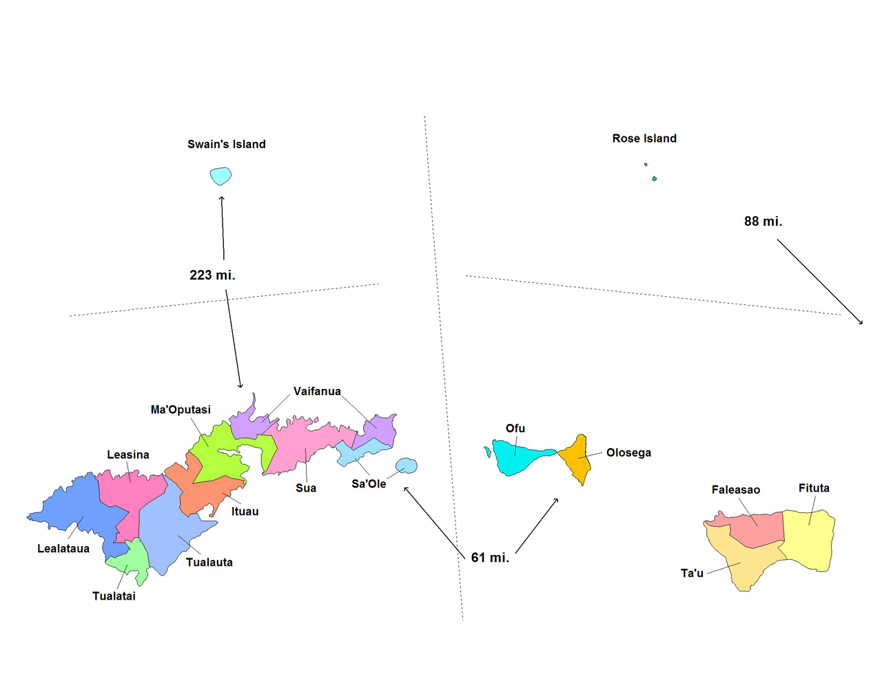
English: Map of the counties of American Samoa for the Eastern and Western Districts. Created by Rarelibra for public domain use. Created using MapInfo Professional v7.5 and using various mapping resources. |
| Թվական | 20 Նոյեմբեր 2006 (original upload date) |
| Աղբյուր | No machine-readable source provided. Own work assumed (based on copyright claims). |
| Հեղինակ | No machine-readable author provided. Electionworld assumed (based on copyright claims). |
Արտոնագրում
| I, the copyright holder of this work, release this work into the public domain. This applies worldwide. In some countries this may not be legally possible; if so: I grant anyone the right to use this work for any purpose, without any conditions, unless such conditions are required by law. |
Նիշքի պատմություն
Մատնահարեք օրվան/ժամին՝ նիշքի այդ պահին տեսքը դիտելու համար։
| Օր/Ժամ | Մանրապատկեր | Օբյեկտի չափը | Մասնակից | Մեկնաբանություն | |
|---|---|---|---|---|---|
| ընթացիկ | 17:53, 11 հունվարի 2008 | | 2112 × 1632 (47 ԿԲ) | Rarelibra | update map |
| 22:24, 20 Նոյեմբերի 2006 |  | 1207 × 827 (42 ԿԲ) | Electionworld | == Summary == Map of the counties of American Samoa for the Eastern and Western Districts. Created by Rarelibra for public domain use. Created using MapInfo Professional v7.5 and using various mapping resources. == Licensing == {{PD |
Նիշքի օգտագործում
Հետևյալ էջը հղվում է այս նիշքին՝
Նիշքի համընդհանուր օգտագործում
Հետևյալ այլ վիքիները օգտագործում են այս նիշքը՝
- Օգտագործումը de.wikipedia.org կայքում
- Օգտագործումը en.wikipedia.org կայքում
- Օգտագործումը es.wikipedia.org կայքում
- Օգտագործումը fa.wikipedia.org կայքում
- Օգտագործումը fr.wikipedia.org կայքում
- Օգտագործումը fy.wikipedia.org կայքում
- Օգտագործումը id.wikipedia.org կայքում
- Օգտագործումը it.wikipedia.org կայքում
- Օգտագործումը ja.wikipedia.org կայքում
- Օգտագործումը ka.wikipedia.org կայքում
- Օգտագործումը mt.wikipedia.org կայքում
- Օգտագործումը nl.wikipedia.org կայքում
- Օգտագործումը os.wikipedia.org կայքում
- Օգտագործումը pl.wikipedia.org կայքում
- Օգտագործումը pt.wikipedia.org կայքում
- Օգտագործումը ru.wikipedia.org կայքում
- Օգտագործումը sv.wikipedia.org կայքում
- Օգտագործումը zh.wikipedia.org կայքում