Պատկեր:Africa-countries-northern.png
Ավելի բարձր կետաչափով տարբերակ չկա։
Africa-countries-northern.png (360 × 392 փիքսել, նիշքի չափը՝ 10 ԿԲ, MIME-տեսակը՝ image/png)

|
Please translate the English parts of this template into Armenian.
Գոյություն ունի այս պատկերի վեկտորային տարբերակը ("SVG"): Եթե այն իր ռաստրային տարբերակից ավելի որակյալ է, ապա գերադասելի է նրա օգտագործումը: File:Africa-countries-northern.png → File:Africa-countries-northern.svg
Վեկտորային գրաֆիկայի մասին ավելին իմանալու համար կարող եք կարդալ պատկերների փոխադրման մասին SVG ֆորմատի: Նաև մատչելի են տեղեկություններ SVG ֆորմատի աջակցման մասին ՄեդիաՎիքիյում: |
 |
Ամփոփում
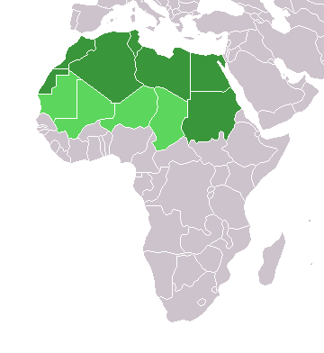
English: Map of countries in geo-political North Africa — as considered by the U.N.
- Credits
from en:Image:Africa-countries-northern.png

|
Այս վավերագրման պատճենահանման, տարածման և/կամ ձևափոխման թույլտվություն կամ լիցենզիայի GNU FDL պայմաններով 1.2 մեկնակերպի կամ ավելի ուշ, հրատարակված Ազատ ծրագրային ապահովության հիմնադրամում, առանց անփոփոխելի հատվածների, առանց բնագիրների, որոնք տեղադրված են առաջին և վերջին շապիկներում: Լիցենզիայի պատճենը գտնվում է GNU Free Documentation License հատվածում: |
| Այս նիշքը հասանելի է Creative Commons Attribution-Share Alike 3.0 Unported արտոնագրի ներքո: | ||
| ||
| Այս արտոնգրության հատկանիշը ավելացված է տվյալ նիշքին որպես GFDL արտոնագրի բարեփոխում: |
Նիշքի պատմություն
Մատնահարեք օրվան/ժամին՝ նիշքի այդ պահին տեսքը դիտելու համար։
| Օր/Ժամ | Մանրապատկեր | Օբյեկտի չափը | Մասնակից | Մեկնաբանություն | |
|---|---|---|---|---|---|
| ընթացիկ | 15:22, 17 Մարտի 2018 | | 360 × 392 (10 ԿԲ) | Maphobbyist | Montenegro border |
| 21:00, 31 Մարտի 2016 |  | 360 × 392 (10 ԿԲ) | Fry1989 | Reverted to version as of 16:12, 13 January 2014 (UTC) | |
| 09:37, 7 Նոյեմբերի 2015 |  | 360 × 392 (10 ԿԲ) | Hpyounes | correction | |
| 16:12, 13 հունվարի 2014 |  | 360 × 392 (10 ԿԲ) | VVVF | See http://unstats.un.org/unsd/methods/m49/m49regin.htm | |
| 15:59, 13 հունվարի 2014 |  | 360 × 392 (13 ԿԲ) | VVVF | Reverted to version as of 20:15, 9 July 2011. See http://unstats.un.org/unsd/methods/m49/m49regin.htm | |
| 12:47, 20 Հուլիսի 2011 |  | 360 × 392 (7 ԿԲ) | Kahusi | See http://unstats.un.org/unsd/methods/m49/m49regin.htm | |
| 20:15, 9 Հուլիսի 2011 |  | 360 × 392 (13 ԿԲ) | Maphobbyist | South Sudan has become independent on July 9, 2011. Sudan and South Sudan are shown with the new international border between them. | |
| 11:13, 5 Մայիսի 2006 |  | 360 × 392 (4 ԿԲ) | Hautala | optimized with png | |
| 16:30, 20 Ապրիլի 2005 |  | 360 × 392 (14 ԿԲ) | Yonghokim | map of countries in Northern Africa. from en:Image:Africa-countries-northern.png {{GFDL}} |
Նիշքի օգտագործում
Այս նիշքին օգտագործող էջեր չկան։
Նիշքի համընդհանուր օգտագործում
Հետևյալ այլ վիքիները օգտագործում են այս նիշքը՝
- Օգտագործումը ce.wikipedia.org կայքում
- Օգտագործումը es.wikipedia.org կայքում
- Օգտագործումը fr.wikipedia.org կայքում
- Օգտագործումը he.wikipedia.org կայքում
- Օգտագործումը ru.wikipedia.org կայքում
- Օգտագործումը sc.wikipedia.org կայքում
- Օգտագործումը sv.wikinews.org կայքում