Պատկեր:Afghanistan map - security by district and opium poppy cultivation by province 2007 - 2008.png
Afghanistan_map_-_security_by_district_and_opium_poppy_cultivation_by_province_2007_-_2008.png (466 × 330 փիքսել, նիշքի չափը՝ 46 ԿԲ, MIME-տեսակը՝ image/png)

|
This military map image could be re-created using vector graphics as an SVG file. This has several advantages; see Commons:Media for cleanup for more information. If an SVG form of this image is available, please upload it and afterwards replace this template with
{{vector version available|new image name}}.
It is recommended to name the SVG file “Afghanistan map - security by district and opium poppy cultivation by province 2007 - 2008.svg”—then the template Vector version available (or Vva) does not need the new image name parameter. |
Ամփոփում
| Նկարագրում |
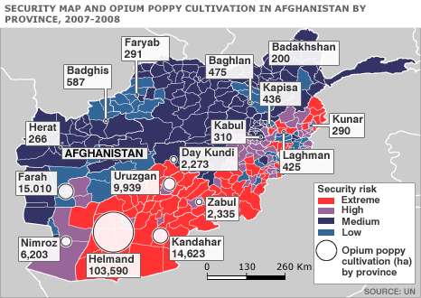
English: Map of Afghanistan showing the security situation by district and opium cultivation by province in the period 2007 to 2008. |
| Թվական | |
| Աղբյուր | http://news.bbc.co.uk/2/hi/south_asia/7663204.stm |
| Հեղինակ | United Nations Department of Safety and Security |
Արտոնագրում
| This image is a map derived from a United Nations map.
Unless stated otherwise, UN maps are to be considered in the public domain. This applies worldwide. UN maps are, in principle, open source material and you can use them in your work or for making your own map. UN requests however that you delete the UN name, logo and reference number upon any modification to the map. Content of your map will be your responsibility. You can state in your publication, if you wish, something like: based on UN map … (map name, map number, revision number and date). See: Geospatial Information Section. And: Geospatial, location data for a better world. |
 |
Original upload log
| Օր/Ժամ | Օբյեկտի չափը | Մասնակից | Մեկնաբանություն |
|---|---|---|---|
| 11 Հոկտեմբեր 2008, 06:52:24 | 466 × 330 (41766 bytes) | Le Behnam (Քննարկում · ներդրում) | {{Information |Description={{en|1=Map of Afghanistan showing the security situation by district and opium cultivation by province in the period 2007 to 2008.}} |Source=http://news.bbc.co.uk/2/hi/south_asia/7663204.stm |Author=United Nations Department of |
Նիշքի պատմություն
Մատնահարեք օրվան/ժամին՝ նիշքի այդ պահին տեսքը դիտելու համար։
| Օր/Ժամ | Մանրապատկեր | Օբյեկտի չափը | Մասնակից | Մեկնաբանություն | |
|---|---|---|---|---|---|
| ընթացիկ | 15:54, 10 Օգոստոսի 2014 | | 466 × 330 (46 ԿԲ) | GifTagger | Bot: Converting file to superior PNG file. (Source: [[File:Afghanistan_map_-_security_by_district_and_opium_poppy_cultivation_by_province_2007_-_2008.gif|Afghanistan_map_-_security_by_district_and_opium_poppy_cultivation_by_province... |
Նիշքի օգտագործում
Հետևյալ 2 էջերը հղվում են այս նիշքին՝
Նիշքի համընդհանուր օգտագործում
Հետևյալ այլ վիքիները օգտագործում են այս նիշքը՝
- Օգտագործումը ar.wikipedia.org կայքում
- Օգտագործումը ca.wikipedia.org կայքում
- Օգտագործումը ce.wikipedia.org կայքում
- Օգտագործումը el.wikipedia.org կայքում
- Օգտագործումը en.wikipedia.org կայքում
- Օգտագործումը fr.wikipedia.org կայքում
- Օգտագործումը hu.wikipedia.org կայքում
- Օգտագործումը ja.wikipedia.org կայքում
- Օգտագործումը nl.wikipedia.org կայքում
- Օգտագործումը pt.wikipedia.org կայքում
- Օգտագործումը ro.wikipedia.org կայքում
- Օգտագործումը ru.wikipedia.org կայքում
- Օգտագործումը www.wikidata.org կայքում