Պատկեր:A new map of Virginia, Maryland, and the improved parts of Pennsylvania & New Jersey. LOC 2005630923 (cropped).jpg
Նախադիտման չափ՝ 683 × 600 պիքսել։ Այլ թույլտվությաններ: 273 × 240 պիքսել | 547 × 480 պիքսել | 875 × 768 պիքսել | 1167 × 1024 պիքսել | 2333 × 2048 պիքսել | 6709 × 5889 պիքսել.
Սկզբնական նիշք (6709 × 5889 փիքսել, նիշքի չափը՝ 6,75 ՄԲ, MIME-տեսակը՝ image/jpeg)
Ամփոփում
| Նկարագրում |
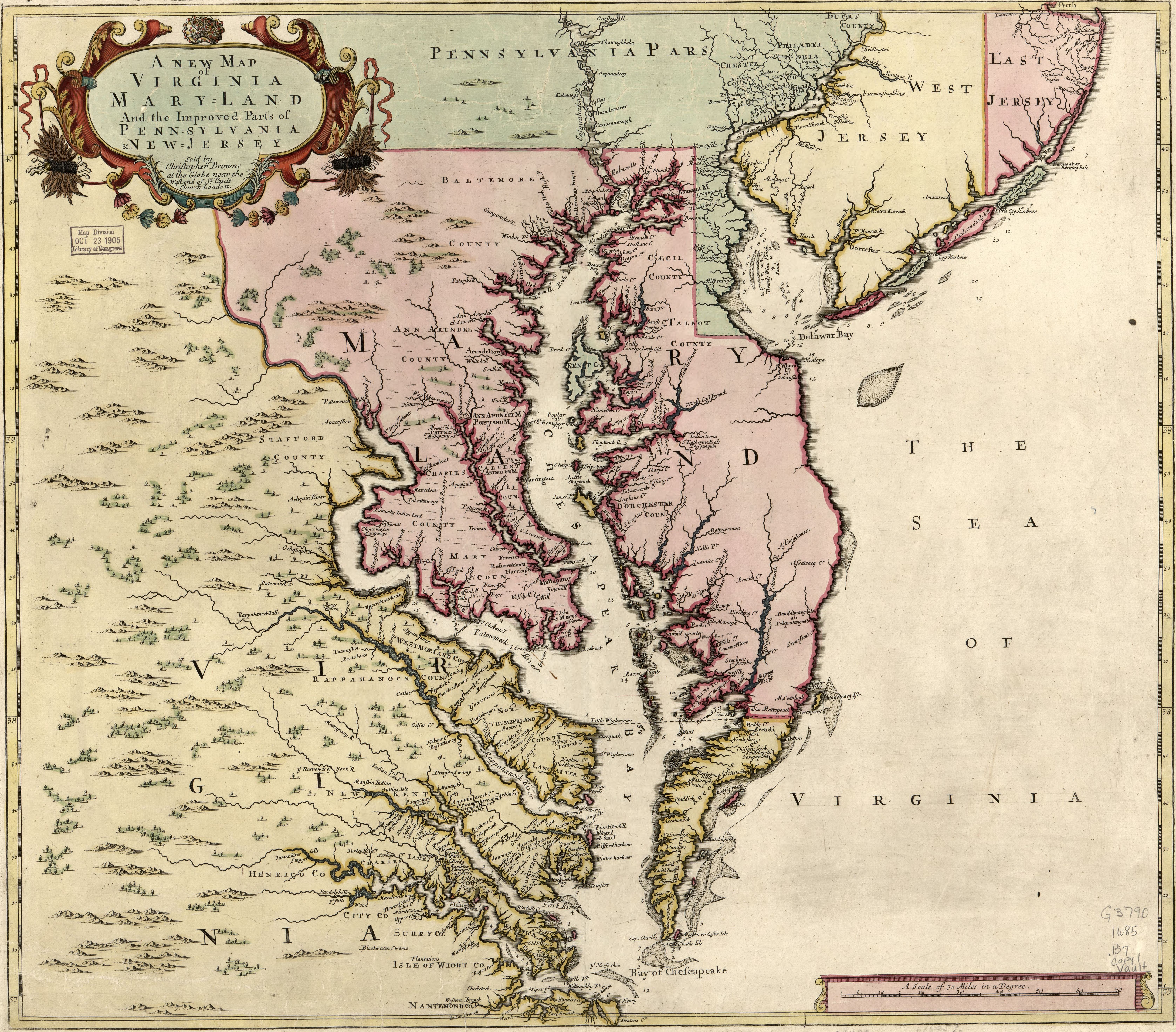
English: Relief shown pictorially. Depths shown by soundings. Date and attribution from On the Map, 1983 (Figure 24). First state of map published originally in 1685 by Christopher Browne with the imprint in the cartouche under the title. No longitude lines are given. Available also through the Library of Congress Web site as a raster image. LC copy annotated with pencil in bottom margin. Stamped and annotated in blue ink on verso: 24. LC copy imperfect: Loose binding along bottom margin. |
||
| Title | A new map of Virginia, Maryland, and the improved parts of Pennsylvania & New Jersey |
||
| Shelf ID | G3790 1685 .B7 | ||
| Թվական | |||
| Աղբյուր | https://www.loc.gov/item/2005630923/ | ||
| Հեղինակ | Browne, Christopher | ||
| Իրավունքներ (Նիշքի վերաօգտագործումը) |
|
||
| Այլ մեկնակերպներ |
|
||
| Location | Pennsylvania · Virginia · United States · New Jersey · Middle Atlantic States · Maryland | ||
| Part of | American Memory · General Maps · Catalog · Geography And Map Division | ||
| Subject | Pennsylvania · Virginia · New Jersey · United States · Maps · Early Works To 1800 · Middle Atlantic States · Maryland |

_in_A_new_map_of_Virginia,_Maryland,_and_the_improved_parts_of_Pennsylvania_%26_New_Jersey._LOC_2005630923_(cropped)_(cropped).jpg)

.jpg)
.jpg)
Արտոնագրում
|
Այս պատկերում գտնվող երկչափ ստեղծագործությունը հանրության սեփականություն է ամբողջ աշխարհում հեղինակի մահվան ժամանակի, կամ առաջի հրատարակման պատճառով:
Այսպիսով, տվյալ վերարտադրումը նույնպես հանրության սեփականություն է: Դա վերաբերվում է ԱՄՆ-ում, Գերմանիայում և ուրիշ բազմաթիվ պետություններում ստեղծված երկերին:
| ||||
Նիշքի պատմություն
Մատնահարեք օրվան/ժամին՝ նիշքի այդ պահին տեսքը դիտելու համար։
| Օր/Ժամ | Մանրապատկեր | Օբյեկտի չափը | Մասնակից | Մեկնաբանություն | |
|---|---|---|---|---|---|
| ընթացիկ | 17:33, 15 Օգոստոսի 2019 | | 6709 × 5889 (6,75 ՄԲ) | Zeete | File:A new map of Virginia, Maryland, and the improved parts of Pennsylvania & New Jersey. LOC 2005630923.jpg cropped 3 % horizontally, 4 % vertically using CropTool with precise mode. |
Նիշքի օգտագործում
Հետևյալ էջը հղվում է այս նիշքին՝
Նիշքի համընդհանուր օգտագործում
Հետևյալ այլ վիքիները օգտագործում են այս նիշքը՝
- Օգտագործումը ast.wikipedia.org կայքում
- Օգտագործումը en.wikipedia.org կայքում
- Օգտագործումը ru.wikipedia.org կայքում
- Օգտագործումը uk.wikipedia.org կայքում
- Օգտագործումը www.wikidata.org կայքում
.jpg)