Պատկեր:1918 map of the Caucasus by the British Army.jpg

Նախադիտման չափ՝ 492 × 599 պիքսել։ Այլ թույլտվությաններ: 197 × 240 պիքսել | 394 × 480 պիքսել | 630 × 768 պիքսել | 840 × 1024 պիքսել | 1681 × 2048 պիքսել | 6076 × 7403 պիքսել.
Սկզբնական նիշք (6076 × 7403 փիքսել, նիշքի չափը՝ 6,44 ՄԲ, MIME-տեսակը՝ image/jpeg)
Ամփոփում
| Նկարագրում |
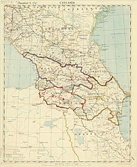
English: 1918 map of the Caucasus by the British Army, with 1919 borders drawn in. |
| Թվական | և 1919 |
| Աղբյուր | https://collections.lib.uwm.edu/digital/collection/agdm/id/1715 |
| Հեղինակ | Great Britain. Army. Royal Engineers. Field Survey Co., 8th |
Արտոնագրում
This work created by the United Kingdom Government is in the public domain.
This is because it is one of the following:
HMSO has declared that the expiry of Crown Copyrights applies worldwide (ref: HMSO Email Reply)
|
 |
Նիշքի պատմություն
Մատնահարեք օրվան/ժամին՝ նիշքի այդ պահին տեսքը դիտելու համար։
| Օր/Ժամ | Մանրապատկեր | Օբյեկտի չափը | Մասնակից | Մեկնաբանություն | |
|---|---|---|---|---|---|
| ընթացիկ | 21:28, 8 Մարտի 2019 | | 6076 × 7403 (6,44 ՄԲ) | Balkanique | User created page with UploadWizard |
Նիշքի օգտագործում
Հետևյալ էջը հղվում է այս նիշքին՝
Նիշքի համընդհանուր օգտագործում
Հետևյալ այլ վիքիները օգտագործում են այս նիշքը՝
- Օգտագործումը az.wikipedia.org կայքում
- Օգտագործումը cs.wikipedia.org կայքում
- Օգտագործումը en.wikipedia.org կայքում
- Օգտագործումը es.wikipedia.org կայքում
- Օգտագործումը fr.wikipedia.org կայքում
- Օգտագործումը it.wikipedia.org կայքում
- Օգտագործումը ka.wikipedia.org կայքում
- Օգտագործումը mt.wikipedia.org կայքում
- Օգտագործումը nl.wikipedia.org կայքում
- Օգտագործումը pl.wikipedia.org կայքում
- Օգտագործումը ru.wikipedia.org կայքում
- Օգտագործումը th.wikipedia.org կայքում
- Օգտագործումը tr.wikipedia.org կայքում
- Օգտագործումը www.wikidata.org կայքում
- Օգտագործումը zh.wikipedia.org կայքում