Պատկեր:1842 A new map of Michigan with its canals roads distances by H.S. Tanner.jpg

Նախադիտման չափ՝ 469 × 600 պիքսել։ Այլ թույլտվությաններ: 188 × 240 պիքսել | 375 × 480 պիքսել | 601 × 768 պիքսել | 801 × 1024 պիքսել | 1602 × 2048 պիքսել | 3352 × 4286 պիքսել.
Սկզբնական նիշք (3352 × 4286 փիքսել, նիշքի չափը՝ 11,62 ՄԲ, MIME-տեսակը՝ image/jpeg)
Ամփոփում
| Նկարագրում |
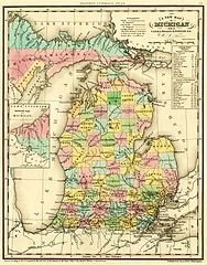
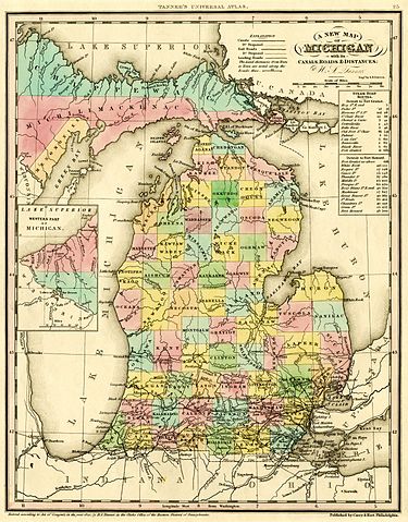
English: A new map of Michigan with its canals, roads & distances / by H.S. Tanner ; engd. by E.B. Dawson. Philadelphia : Carey & Hart, [1842].
Scan of a map in the collection of the Michigan State University Map Library. Original map was detached from an atlas published in 1842: A new universal atlas. Philadelphia : Carey & Hart, 1842. MSU Libraries catalog record: http://catalog.lib.msu.edu/record=b12049211~S39a The map shows early names (assigned 1840) of northern Michigan counties, many of which were renamed in 1843. Some of these names are misspelled: Correct spelling / Name on map:
|
|||||||||||||||||||
| Թվական | 1842, ©1841 | |||||||||||||||||||
| Աղբյուր | http://www.lib.msu.edu/branches/map/MiJPEGS/843-D-1842-Tanner/ | |||||||||||||||||||
| Հեղինակ |
|
|||||||||||||||||||
Արտոնագրում
This media file is in the public domain in the United States. This applies to U.S. works where the copyright has expired, often because its first publication occurred prior to January 1, 1929, and if not then due to lack of notice or renewal. See this page for further explanation.
|
 | |
 |
This image might not be in the public domain outside of the United States; this especially applies in the countries and areas that do not apply the rule of the shorter term for US works, such as Canada, Mainland China (not Hong Kong or Macao), Germany, Mexico, and Switzerland. The creator and year of publication are essential information and must be provided. See Wikipedia:Public domain and Wikipedia:Copyrights for more details.
|
Նիշքի պատմություն
Մատնահարեք օրվան/ժամին՝ նիշքի այդ պահին տեսքը դիտելու համար։
| Օր/Ժամ | Մանրապատկեր | Օբյեկտի չափը | Մասնակից | Մեկնաբանություն | |
|---|---|---|---|---|---|
| ընթացիկ | 19:04, 5 Հոկտեմբերի 2016 | | 3352 × 4286 (11,62 ՄԲ) | TimK MSI | cropped |
| 19:03, 5 Հոկտեմբերի 2016 |  | 4095 × 5296 (7,33 ՄԲ) | TimK MSI | {{Information |Description ={{en|1=A new map of Michigan with its canals, roads & distances / by H.S. Tanner ; engd. by E.B. Dawson. Philadelphia : Carey & Hart, [1842]. Scan of a map in the collection of the Michigan State University Map Library.... |
Նիշքի օգտագործում
Այս նիշքին օգտագործող էջեր չկան։
Նիշքի համընդհանուր օգտագործում
Հետևյալ այլ վիքիները օգտագործում են այս նիշքը՝
- Օգտագործումը en.wikipedia.org կայքում