Պատկեր:Åland Political Map-en.svg

Size of this PNG preview of this SVG file: 595 × 600 պիքսել. Այլ թույլտվությաններ: 238 × 240 պիքսել | 476 × 480 պիքսել | 762 × 768 պիքսել | 1016 × 1024 պիքսել | 2032 × 2048 պիքսել | 996 × 1004 պիքսել.
Սկզբնական նիշք (SVG-նիշք, անվանապես 996 × 1004 փիքսել, նիշքի չափը՝ 219 ԿԲ)
Ամփոփում
| Նկարագրում |
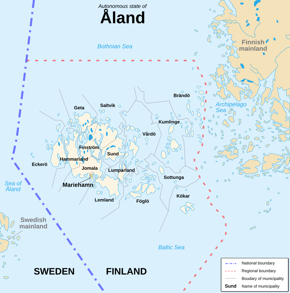
English: Political map of the autonomous finnish province of Åland, in english. Shows the national, regional and municipal boundaries about Åland islands. Français : Carte politique de l'État libre associé d'Åland, en anglais. La carte montre les frontières internationales, régionales et municipales concernant l'archipel d'Åland. |
||
| Թվական | |||
| Աղբյուր |
English: Image:Alandmunicipalities.png and Image:Åland map.png, from Demis (see the approval e-mail and Demis forum). Français : Image:Alandmunicipalities.png et Image:Åland map.png, elles-même basées sur le site internet de Demis (voir le courriel d'autorisation et le forum de Demis). |
||
| Հեղինակ | Sémhur (talk) | ||
| Այլ մեկնակերպներ |
|
||
| Հղում (required by the license) | © Sémhur / Wikimedia Commons / | ||
| SVG | W3C-validity not checked. Սա վեկտոր գրաֆիկական պատկեր է ստեղծված է եղել Inkscape օգնությամբ: .
|
||
| Atelier graphique |

| Տեսախցիկի տեղագրություն | | Այս և ուրիշ պատկերներ իրենց տեղագրությամբ OpenStreetMap |
|---|
Արտոնագրում
Ես, այս աշխատանքի հեղինակային իրավունքների տերը, ներկա հրատարակում եմ սրա հետևյալ լիցենզիաների պայմաններով
| Copyleft: This work of art is free; you can redistribute it and/or modify it according to terms of the Free Art License. You will find a specimen of this license on the Copyleft Attitude site as well as on other sites. |
This file is licensed under the Creative Commons Attribution-Share Alike 4.0 International, 3.0 Unported, 2.5 Generic, 2.0 Generic and 1.0 Generic license.
- Դուք ազատ եք՝
- կիսվել ստեղծագործությամբ – պատճենել, տարածել և փոխանցել այս աշխատանքը։
- վերափոխել – ադապտացնել աշխատանքը
- Պահպանելով հետևյալ պայմանները'
- հղում – Դուք պետք է նշեք հեղինակի (իրավատիրոջ) հղումը:
- համանման տարածում – Եթե դուք ձևափոխում եք, փոխակերպում, կամ այս աշխատանքի հիման վրա ստեղծում եք նոր աշխատանք, ապա ձեր ստեղծածը կարող է տարածվել միայն նույն կամ համարժեք թույլատրագրով։
Կարող եք ընտրել այս թույլատրագրերից ցանկացածը։
Նիշքի պատմություն
Մատնահարեք օրվան/ժամին՝ նիշքի այդ պահին տեսքը դիտելու համար։
| Օր/Ժամ | Մանրապատկեր | Օբյեկտի չափը | Մասնակից | Մեկնաբանություն | |
|---|---|---|---|---|---|
| ընթացիկ | 16:11, 21 Օգոստոսի 2007 | | 996 × 1004 (219 ԿԲ) | Sémhur | {{Information |Description=Political map of the autonomous finnish province of Åland, in english.<br/> Shows the national, regional and municipal boundaries about Åland islands. |Source=Own work. Based on Image:Alandmunicipalities.png and [[:Image: |
Նիշքի օգտագործում
Հետևյալ էջը հղվում է այս նիշքին՝
Նիշքի համընդհանուր օգտագործում
Հետևյալ այլ վիքիները օգտագործում են այս նիշքը՝
- Օգտագործումը ca.wikipedia.org կայքում
- Օգտագործումը en.wikipedia.org կայքում
- Օգտագործումը es.wikipedia.org կայքում
- Օգտագործումը ga.wikipedia.org կայքում
- Օգտագործումը gl.wikipedia.org կայքում
- Օգտագործումը li.wikipedia.org կայքում
- Օգտագործումը nl.wikipedia.org կայքում
- Օգտագործումը ru.wikipedia.org կայքում
- Օգտագործումը www.wikidata.org կայքում