Պատկեր:WW2-Holocaust-Poland-ru.png
Ավելի բարձր կետաչափով տարբերակ չկա։
WW2-Holocaust-Poland-ru.png (364 × 339 փիքսել, նիշքի չափը՝ 121 ԿԲ, MIME-տեսակը՝ image/png)
| Նկարագրում |
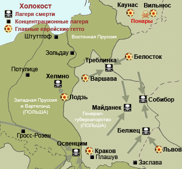
Map of the Holocaust in Poland during World War II, 1939-1945. This map shows all extermination camps (or death camps), most major concentration camps, labor camps, prison camps, ghettos, major deportation routes and major massacre sites. Notes: 1. Extermination camps were dedicated death camps, but all camps and ghettos took a toll of many, many lives. 2. Concentration camps include labor camps, prison camps & transit camps. 3. Not all camps & ghettos are shown. 4. Borders are at the height of Axis domination (1942). 5. Some regions have German designations (e.g. "Ostland"), with the present country name denoted in uppercase letters in parenthesis below the German designation (e.g. "(AUSTRIA)"). 6. Present (2007) borders are dotted. |
| Թվական | (UTC) |
| Աղբյուր | |
| Հեղինակ |
|
| Այլ մեկնակերպներ |
[]
|


.png)


.png)


| Սա խմբագրված պատկեր է, որը համեմատ բնօրինակին ենթարկվել է թվային մշակման։ Փոփոխությունները՝ Translate to Russian: Սկզբնական պատկերը գտնվում է այստեղ՝ WW2-Holocaust-Poland.PNG։ Խմբագրել է Winterpool մասնակիցը։
|
Ես, սույն աշխատանքի հեղինակային իրավունքների տերը, այսուհետ այն հրատարակում եմ հետևյալ արտոնագրի ներքո։
This file is licensed under the Creative Commons Attribution 3.0 Unported license.
- Դուք ազատ եք՝
- կիսվել ստեղծագործությամբ – պատճենել, տարածել և փոխանցել այս աշխատանքը։
- վերափոխել – ադապտացնել աշխատանքը
- Պահպանելով հետևյալ պայմանները'
- հղում – Դուք պետք է նշեք հեղինակի (իրավատիրոջ) հղումը:
Original upload log
This image is a derivative work of the following images:
- File:WW2-Holocaust-Poland.PNG licensed with Cc-by-3.0
- 2009-02-19T18:27:36Z Piotrus 364x339 (110907 Bytes) Reverted to version as of 18:22, 19 February 2009
- 2009-02-19T18:26:01Z Piotrus 700x393 (108396 Bytes) Reverted to version as of 18:24, 19 February 2009
- 2009-02-19T18:25:43Z Piotrus 700x393 (108396 Bytes) Added legend from the original map
- 2009-02-19T18:24:31Z Piotrus 700x393 (108396 Bytes) Added legend from the original map
- 2009-02-19T18:22:38Z Poeticbent 364x339 (110907 Bytes) added legend to map
- 2009-02-18T18:34:02Z Piotrus 364x339 (75862 Bytes) {{Information |Description=Map of the Holocaust in Poland during World War II, 1939-1945. This map shows all extermination camps (or ''death camps''), most major concentration camps, labor camps, prison camps, ghettos, major
Uploaded with derivativeFX
Նիշքի պատմություն
Մատնահարեք օրվան/ժամին՝ նիշքի այդ պահին տեսքը դիտելու համար։
| Օր/Ժամ | Մանրապատկեր | Օբյեկտի չափը | Մասնակից | Մեկնաբանություն | |
|---|---|---|---|---|---|
| ընթացիկ | 22:38, 17 Նոյեմբերի 2010 | | 364 × 339 (121 ԿԲ) | Bogomolov.PL | Исправлено написание Собибур на Собибор |
| 06:07, 12 Մարտի 2010 |  | 364 × 339 (102 ԿԲ) | Pessimist2006 | {{Information |Description=Map of the Holocaust in Poland during World War II, 1939-1945. <br> This map shows all extermination camps (or ''death camps''), most major concentration camps, labor camps, prison camps, ghettos, major deportation routes and ma |
Նիշքի օգտագործում
Հետևյալ էջը հղվում է այս նիշքին՝
Նիշքի համընդհանուր օգտագործում
Հետևյալ այլ վիքիները օգտագործում են այս նիշքը՝
- Օգտագործումը ru.wikipedia.org կայքում