Պատկեր:UN Palestine Partition Versions 1947.jpg

Սկզբնական նիշք (1370 × 2838 փիքսել, նիշքի չափը՝ 1,46 ՄԲ, MIME-տեսակը՝ image/jpeg)
Ամփոփում
| Նկարագրում |
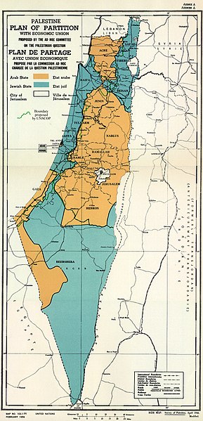
English: February 1956 Map of UN Partition Plan for Palestine, adopted 29 Nov 1947, with boundary of previous UNSCOP partition plan added in green. العربية: خريطة رسمية بعد قرار الأمم المتحدة بتاريخ 29 نوفمبر 1947م بتقسيم فلسطين إلى دولة عربية ويهودية وتحويل القدس لمدينة دولية. |
| Թվական | |
| Աղբյուր | m0103_1b.gif on PLAN OF PARTITION is from UNGA Resolution 181 (27 Nov 1947). Overdrawn UNSCOP boundary is from United Nations Special Committee on Palestine, Report to the General Assembly, 3 Sep 1947, Volume II, A/364, Add. 1. |
| Հեղինակ | Zero0000A/RES/181(II) |
| Այլ մեկնակերպներ |
.jpg)
.jpg)
.jpg)
.jpg)
Copyright status of map:
| This image is a map derived from a United Nations map.
Unless stated otherwise, UN maps are to be considered in the public domain. This applies worldwide. UN maps are, in principle, open source material and you can use them in your work or for making your own map. UN requests however that you delete the UN name, logo and reference number upon any modification to the map. Content of your map will be your responsibility. You can state in your publication, if you wish, something like: based on UN map … (map name, map number, revision number and date). See: Geospatial Information Section. And: Geospatial, location data for a better world. |
 |
Արտոնագրում
- Դուք ազատ եք՝
- կիսվել ստեղծագործությամբ – պատճենել, տարածել և փոխանցել այս աշխատանքը։
- վերափոխել – ադապտացնել աշխատանքը
- Պահպանելով հետևյալ պայմանները'
- հղում – Դուք պետք է նշեք հեղինակի (իրավատիրոջ) հղումը:
- համանման տարածում – Եթե դուք ձևափոխում եք, փոխակերպում, կամ այս աշխատանքի հիման վրա ստեղծում եք նոր աշխատանք, ապա ձեր ստեղծածը կարող է տարածվել միայն նույն կամ համարժեք թույլատրագրով։

|
This historical map image could be re-created using vector graphics as an SVG file. This has several advantages; see Commons:Media for cleanup for more information. If an SVG form of this image is available, please upload it and afterwards replace this template with
{{vector version available|new image name}}.
It is recommended to name the SVG file “UN Palestine Partition Versions 1947.svg”—then the template Vector version available (or Vva) does not need the new image name parameter. |


Նիշքի պատմություն
Մատնահարեք օրվան/ժամին՝ նիշքի այդ պահին տեսքը դիտելու համար։
| Օր/Ժամ | Մանրապատկեր | Օբյեկտի չափը | Մասնակից | Մեկնաբանություն | |
|---|---|---|---|---|---|
| ընթացիկ | 12:07, 10 Օգոստոսի 2013 | | 1370 × 2838 (1,46 ՄԲ) | Zero0000 | User created page with UploadWizard |
Նիշքի օգտագործում
Հետևյալ 3 էջերը հղվում են այս նիշքին՝
Նիշքի համընդհանուր օգտագործում
Հետևյալ այլ վիքիները օգտագործում են այս նիշքը՝
- Օգտագործումը ar.wikipedia.org կայքում
- Օգտագործումը arz.wikipedia.org կայքում
- Օգտագործումը azb.wikipedia.org կայքում
- Օգտագործումը az.wikipedia.org կայքում
- Օգտագործումը bg.wikipedia.org կայքում
- Օգտագործումը bn.wikipedia.org կայքում
- Օգտագործումը cdo.wikipedia.org կայքում
- Օգտագործումը cy.wikipedia.org կայքում
- Օգտագործումը de.wikipedia.org կայքում
- Օգտագործումը el.wikipedia.org կայքում
- Օգտագործումը en.wikipedia.org կայքում
- 1948 Arab–Israeli War
- United Nations Partition Plan for Palestine
- Talk:United Nations Partition Plan for Palestine
- International zone
- International city
- Israel
- Arab localities in Israel
- Template talk:Largest cities of Israel
- Talk:1947–1948 civil war in Mandatory Palestine/Archive 2
- Wikipedia:Editor assistance/Requests/Archive 122
- Talk:Israel/Archive 47
- Talk:Israel/Archive 49
- November 1947
- Talk:Jerusalem/Archive 25
- User:Falcaorib
- Talk:Religion in Israel/Archive 1
- Nakba
- Wikipedia talk:Noticeboard for India-related topics/Archive 74
- User:Skingames2012/sandbox
- Օգտագործումը es.wikipedia.org կայքում
- Օգտագործումը et.wikipedia.org կայքում
- Օգտագործումը eu.wikipedia.org կայքում
- Օգտագործումը fa.wikipedia.org կայքում
- Օգտագործումը fi.wikipedia.org կայքում
- Օգտագործումը fr.wikipedia.org կայքում
Տեսնել այս նիշքի ավելի համընդհանուր օգտագործումը: