Պատկեր:Tenochtitlan y Golfo de Mexico 1524.jpg

Սկզբնական նիշք (1600 × 1010 փիքսել, նիշքի չափը՝ 609 ԿԲ, MIME-տեսակը՝ image/jpeg)
Ամփոփում
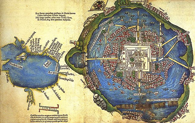
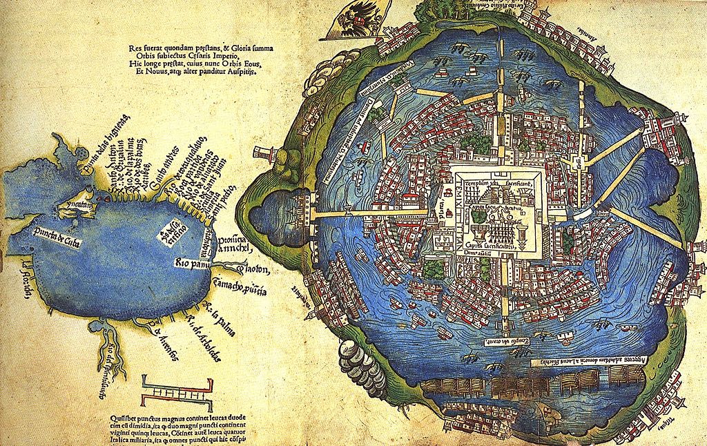
Página de «Praeclara Ferdinandi Cortesii de nova maris Oceani Hispania narratio, Sacratissimo ac Invictissimo Carolo Romanorum Imperatori Semper Augusto, Hispaniarum & Regi Anno Domini M. D. XX transmisa; ... per Doctorem Petrum Savorgnanum Foro Juliensem Reven. D. Joan. de Revelles Episco. Vienensis Secretarium ex Hispano idiomate in latinum versa Anno Domini M. D. XXIIII. KL. Martii», primera publicación de la segunda carta de Hernán Cortés al Imperador Carlos V, por Fridericum Peypus en Núremberg en 1524, tal como está conservada en la Biblioteca Newberry de Chicago.
Muestra un mapa de Tenochtitlán preparado por los Mexicas y presentado a Cortés como un regalo en el período 1519-1521, y un mapa de la región de la Costa del Golfo mexicano y la parte sureste de lo que son hoy los Estados Unidos. El autor del mapa, desconocido, pudo ser un mexica o un conquistador español, según el sitio de la Biblioteca del Congreso de Estados Unidos (véase [1]), donde se presenta otra versión, monocromática, que pertenece a la colección de grabados iluminados donados a la Biblioteca del Congreso de Estados Unidos por Lessing J. Rosenwald. (Rosenwald Collection, Rare Book and Special Collections Division).
For more information about this map, see This new world now revealed: Hernan Cortes and the presentation of Mexico to Europe, by Elizabeth Hill Boone.
Արտոնագրում
|
Այս պատկերում գտնվող երկչափ ստեղծագործությունը հանրության սեփականություն է ամբողջ աշխարհում հեղինակի մահվան ժամանակի, կամ առաջի հրատարակման պատճառով:
Այսպիսով, տվյալ վերարտադրումը նույնպես հանրության սեփականություն է: Դա վերաբերվում է ԱՄՆ-ում, Գերմանիայում և ուրիշ բազմաթիվ պետություններում ստեղծված երկերին: {{PD-Art}} template without license parameter: please specify why the underlying work is public domain in both the source country and the United States
(Usage: {{PD-Art|1=|deathyear=''year of author's death''|country=''source country''}}, where parameter #1 can be PD-old-auto, PD-old-auto-expired, PD-old-auto-1996, PD-old-100 or similar. See Commons:Multi-license copyright tags for more information.) | ||||
Նիշքի պատմություն
Մատնահարեք օրվան/ժամին՝ նիշքի այդ պահին տեսքը դիտելու համար։
| Օր/Ժամ | Մանրապատկեր | Օբյեկտի չափը | Մասնակից | Մեկնաբանություն | |
|---|---|---|---|---|---|
| ընթացիկ | 11:18, 14 Հունիսի 2014 | | 1600 × 1010 (609 ԿԲ) | Lupo | Even larger version from http://yesisuki.blogspot.com/2010/04/mapa-de-la-laguna-de-techtitlan.html |
| 23:19, 22 Նոյեմբերի 2012 |  | 500 × 316 (189 ԿԲ) | Nicolas Perrault III | Better, larger version. Source: http://www.google.ca/imgres?um=1&hl=en&client=firefox-a&sa=N&tbo=d&rls=org.mozilla:en-US:official&biw=928&bih=474&tbm=isch&tbnid=mNR0I3B3z7xSPM:&imgrefurl=http://fuckyeahmexico.tumblr.com/post/35858337036/willigula-like-... | |
| 21:01, 10 Մայիսի 2010 |  | 383 × 239 (69 ԿԲ) | Uxbona | centered image | |
| 05:57, 21 Ապրիլի 2007 |  | 400 × 274 (34 ԿԲ) | Maurice Marcellin~commonswiki | Página de libro publicado en 1524, perteneciente a la biblioteca Newberry de Chicago, muestra un mapa de Tenochtitlán (derecha) y un esquema del Golfo de México. Autor: un acompañante de Hernán Cortés. Category:Mexico City |
Նիշքի օգտագործում
Հետևյալ 2 էջերը հղվում են այս նիշքին՝
Նիշքի համընդհանուր օգտագործում
Հետևյալ այլ վիքիները օգտագործում են այս նիշքը՝
- Օգտագործումը ar.wikipedia.org կայքում
- Օգտագործումը ca.wikipedia.org կայքում
- Օգտագործումը en.wikipedia.org կայքում
- Օգտագործումը es.wikipedia.org կայքում
- Օգտագործումը fr.wikipedia.org կայքում
- Օգտագործումը hu.wikipedia.org կայքում
- Օգտագործումը it.wikipedia.org կայքում
- Օգտագործումը oc.wikipedia.org կայքում
- Օգտագործումը pt.wikipedia.org կայքում
- Օգտագործումը ru.wikipedia.org կայքում
- Օգտագործումը uk.wikipedia.org կայքում
- Օգտագործումը vi.wikipedia.org կայքում