Պատկեր:Smithisland milt.jpg

Նախադիտման չափ՝ 549 × 600 պիքսել։ Այլ թույլտվությաններ: 220 × 240 պիքսել | 439 × 480 պիքսել | 703 × 768 պիքսել | 1024 × 1119 պիքսել.
Սկզբնական նիշք (1024 × 1119 փիքսել, նիշքի չափը՝ 209 ԿԲ, MIME-տեսակը՝ image/jpeg)
Ամփոփում
| Նկարագրում |
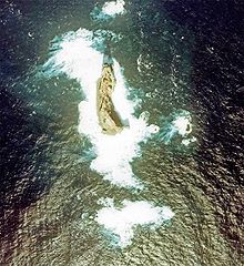
English: Aerial Photograph of Smith Island at Izu Islands in 1978.
日本語: 須美寿島の航空写真(1978年)。1990年代に島が部分的に崩落したため、現在とは形状が異なっている。 |
| Թվական | |
| Աղբյուր |
日本語: 国土画像情報(カラー空中写真) |
| Հեղինակ |
日本語: 国土交通省 |
Արտոնագրում

|
The copyright holder of this file, the Ministry of Land, Infrastructure, Transport and Tourism of Japan, allows anyone to use it for any purpose, provided that the copyright holder is properly attributed. Redistribution, derivative work, commercial use, and all other use is permitted. |
Հղում:
Copyright © National Land Image Information (Color Aerial Photographs), Ministry of Land, Infrastructure, Transport and Tourism
|
 |
This image is copyrighted by the Ministry of Land, Infrastructure, Transport and Tourism of Japan. For terms of use, see the stipulation to use of National Land Information (in Japanese) and message from MLIT (in Japanese and English). When you display this image on an article, include the following phrase in the description: "Made based on National Land Image Information (Color Aerial Photographs), Ministry of Land, Infrastructure, Transport and Tourism".
|
Նիշքի պատմություն
Մատնահարեք օրվան/ժամին՝ նիշքի այդ պահին տեսքը դիտելու համար։
| Օր/Ժամ | Մանրապատկեր | Օբյեկտի չափը | Մասնակից | Մեկնաբանություն | |
|---|---|---|---|---|---|
| ընթացիկ | 14:38, 9 Մայիսի 2006 | | 1024 × 1119 (209 ԿԲ) | Tdk~commonswiki | Aerial Photograph of Smith Island at Izu Islands in 1978.{{AerialPhotograph-mlitJP}} |
Նիշքի օգտագործում
Հետևյալ էջը հղվում է այս նիշքին՝
Նիշքի համընդհանուր օգտագործում
Հետևյալ այլ վիքիները օգտագործում են այս նիշքը՝
- Օգտագործումը arz.wikipedia.org կայքում
- Օգտագործումը az.wikipedia.org կայքում
- Օգտագործումը ceb.wikipedia.org կայքում
- Օգտագործումը ckb.wikipedia.org կայքում
- Օգտագործումը cs.wikipedia.org կայքում
- Օգտագործումը de.wikipedia.org կայքում
- Օգտագործումը en.wikipedia.org կայքում
- Օգտագործումը es.wikipedia.org կայքում
- Օգտագործումը fa.wikipedia.org կայքում
- Օգտագործումը frr.wikipedia.org կայքում
- Օգտագործումը he.wikipedia.org կայքում
- Օգտագործումը it.wikipedia.org կայքում
- Օգտագործումը ja.wikipedia.org կայքում
- Օգտագործումը ko.wikipedia.org կայքում
- Օգտագործումը lt.wikipedia.org կայքում
- Օգտագործումը mr.wikipedia.org կայքում
- Օգտագործումը no.wikipedia.org կայքում
- Օգտագործումը pt.wikipedia.org կայքում
- Օգտագործումը ru.wikipedia.org կայքում
- Օգտագործումը sk.wikipedia.org կայքում
- Օգտագործումը tr.wikipedia.org կայքում
- Օգտագործումը uk.wikipedia.org կայքում
- Օգտագործումը www.wikidata.org կայքում
- Օգտագործումը zh.wikipedia.org կայքում