Պատկեր:Sino-Indian Geography.png
Սկզբնական նիշք (918 × 648 փիքսել, նիշքի չափը՝ 1,36 ՄԲ, MIME-տեսակը՝ image/png)
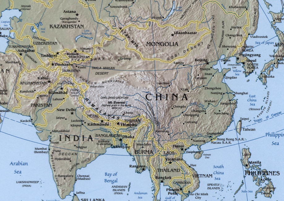
A map showing the geography of the Sino-Indian region.
A physical map with relief showing shading. Scale 1:48,000,000 ; Azimuthal equal-area projection (W 50--W 1650/N 880--S 180).
Cropped from a larger map showing Asia - which may be found on the Library of Congress website (the source image) or alternatively on the CIA World Factbook.
Image created and published by the Central Intelligence Agency of the United States of America in 2004.
Note
The land border between the China and India over Arunachal Pradesh / South Tibet reflects actual control, without dotted line showing claims
This image is in the public domain because it contains materials that originally came from the United States Central Intelligence Agency's World Factbook.
|
 |
Նիշքի պատմություն
Մատնահարեք օրվան/ժամին՝ նիշքի այդ պահին տեսքը դիտելու համար։
| Օր/Ժամ | Մանրապատկեր | Օբյեկտի չափը | Մասնակից | Մեկնաբանություն | |
|---|---|---|---|---|---|
| ընթացիկ | 19:32, 22 Նոյեմբերի 2004 | | 918 × 648 (1,36 ՄԲ) | OldakQuill | |
| 09:38, 22 Նոյեմբերի 2004 |  | 354 × 350 (98 ԿԲ) | OldakQuill | A map showing the geography of the Sino-Indian region. {{pd}} |
Նիշքի օգտագործում
Հետևյալ 2 էջերը հղվում են այս նիշքին՝
Նիշքի համընդհանուր օգտագործում
Հետևյալ այլ վիքիները օգտագործում են այս նիշքը՝
- Օգտագործումը ar.wikipedia.org կայքում
- Օգտագործումը de.wikipedia.org կայքում
- Օգտագործումը en.wikipedia.org կայքում
- Օգտագործումը fa.wikipedia.org կայքում
- Օգտագործումը fr.wikipedia.org կայքում
- Օգտագործումը ha.wikipedia.org կայքում
- Օգտագործումը hi.wikipedia.org կայքում
- Օգտագործումը id.wikipedia.org կայքում
- Օգտագործումը mn.wikipedia.org կայքում
- Օգտագործումը ms.wikipedia.org կայքում
- Օգտագործումը nl.wikipedia.org կայքում
- Օգտագործումը pnb.wikipedia.org կայքում
- Օգտագործումը ru.wikipedia.org կայքում
- Օգտագործումը sr.wikipedia.org կայքում
- Օգտագործումը tr.wikipedia.org կայքում
- Օգտագործումը uk.wikipedia.org կայքում
- Օգտագործումը ur.wikipedia.org կայքում
- Օգտագործումը uz.wikipedia.org կայքում
- Օգտագործումը www.wikidata.org կայքում
- Օգտագործումը zh.wikipedia.org կայքում