Պատկեր:Romania1941.png
Նախադիտման չափ՝ 800 × 589 պիքսել։ Այլ թույլտվությաններ: 320 × 236 պիքսել | 640 × 472 պիքսել | 950 × 700 պիքսել.
Սկզբնական նիշք (950 × 700 փիքսել, նիշքի չափը՝ 60 ԿԲ, MIME-տեսակը՝ image/png)
Ամփոփում
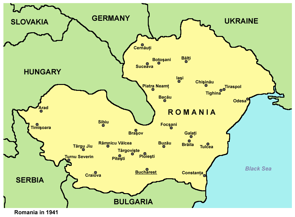
| Նկարագրում | Historic map of Romania in 1941. |
| Թվական | 28 Դեկտեմբեր 2006 (original upload date) |
| Աղբյուր | Բեռնողի սեփական աշխատանք |
| Հեղինակ | PANONIAN |
Source and license

|
This map has been uploaded by Electionworld from en.wikipedia.org to enable the |
self made map by user:PANONIAN
Արտոնագրում
| I, the copyright holder of this work, release this work into the public domain. This applies worldwide. In some countries this may not be legally possible; if so: I grant anyone the right to use this work for any purpose, without any conditions, unless such conditions are required by law. |
References
- http://upload.moldova.org/politicom/Transnistria/transnistria_holocaust.gif
- http://kehilalinks.jewishgen.org/sokiryany/1942Romania.gif
- http://academic.evergreen.edu/g/grossmaz/20thCentRomania.jpg
- http://www.ushmm.org/lcmedia/map/lc/image/rom69090.gif
- http://www.ushmm.org/lcmedia/map/lc/image/rom19020.gif
- http://www.ushmm.org/lcmedia/map/lc/image/rom73160.gif
- http://www.freewebs.com/networksromania/_45403710_romania_1942_2009_466.gif
- http://4.bp.blogspot.com/-q2BmrHGgWQ4/Tnr7eEPaGsI/AAAAAAAAAIw/tnEOeauMgMU/s1600/Romania+1941-1944.jpg
- http://www.zum.de/whkmla/histatlas/balkans/rum1941s.gif
Նիշքի պատմություն
Մատնահարեք օրվան/ժամին՝ նիշքի այդ պահին տեսքը դիտելու համար։
| Օր/Ժամ | Մանրապատկեր | Օբյեկտի չափը | Մասնակից | Մեկնաբանություն | |
|---|---|---|---|---|---|
| ընթացիկ | 13:30, 29 Սեպտեմբերի 2012 | | 950 × 700 (60 ԿԲ) | PANONIAN | improved version |
| 18:51, 28 Դեկտեմբերի 2006 |  | 359 × 253 (13 ԿԲ) | Electionworld | {{ew|en|PANONIAN}} historic map of Romania (self made) {{PD-self}} Category:Maps of the history of Romania Category:Maps of World War II in Europe |
Նիշքի օգտագործում
Հետևյալ 2 էջերը հղվում են այս նիշքին՝
Նիշքի համընդհանուր օգտագործում
Հետևյալ այլ վիքիները օգտագործում են այս նիշքը՝
- Օգտագործումը af.wikipedia.org կայքում
- Օգտագործումը ba.wikipedia.org կայքում
- Օգտագործումը be-tarask.wikipedia.org կայքում
- Օգտագործումը be.wikipedia.org կայքում
- Օգտագործումը bg.wikipedia.org կայքում
- Օգտագործումը bs.wikipedia.org կայքում
- Օգտագործումը ca.wikipedia.org կայքում
- Օգտագործումը cs.wikipedia.org կայքում
- Օգտագործումը cv.wikipedia.org կայքում
- Օգտագործումը de.wikipedia.org կայքում
- Օգտագործումը el.wikipedia.org կայքում
- Օգտագործումը en.wikipedia.org կայքում
- Օգտագործումը eo.wikipedia.org կայքում
- Օգտագործումը eu.wikipedia.org կայքում
- Օգտագործումը fi.wikipedia.org կայքում
- Օգտագործումը fo.wikipedia.org կայքում
- Օգտագործումը gl.wikipedia.org կայքում
- Օգտագործումը gu.wikipedia.org կայքում
- Օգտագործումը he.wikipedia.org կայքում
- Օգտագործումը hi.wikipedia.org կայքում
- Օգտագործումը hr.wikipedia.org կայքում
- Օգտագործումը hu.wikipedia.org կայքում
- Օգտագործումը hyw.wikipedia.org կայքում
- Օգտագործումը id.wikipedia.org կայքում
- Օգտագործումը incubator.wikimedia.org կայքում
- Օգտագործումը is.wikipedia.org կայքում
- Օգտագործումը it.wikipedia.org կայքում
- Օգտագործումը ja.wikipedia.org կայքում
- Օգտագործումը jv.wikipedia.org կայքում
- Օգտագործումը ko.wikipedia.org կայքում
- Օգտագործումը lt.wikipedia.org կայքում
- Օգտագործումը lv.wikipedia.org կայքում
- Օգտագործումը mk.wikipedia.org կայքում
Տեսնել այս նիշքի ավելի համընդհանուր օգտագործումը: