Պատկեր:Roman Italy.gif

Նախադիտման չափ՝ 519 × 600 պիքսել։ Այլ թույլտվությաններ: 208 × 240 պիքսել | 415 × 480 պիքսել | 846 × 978 պիքսել.
Սկզբնական նիշք (846 × 978 փիքսել, նիշքի չափը՝ 72 ԿԲ, MIME-տեսակը՝ image/gif)
Ամփոփում

|
This locator map image could be re-created using vector graphics as an SVG file. This has several advantages; see Commons:Media for cleanup for more information. If an SVG form of this image is available, please upload it and afterwards replace this template with
{{vector version available|new image name}}.
It is recommended to name the SVG file “Roman Italy.svg”—then the template Vector version available (or Vva) does not need the new image name parameter. |

| Նկարագրում |
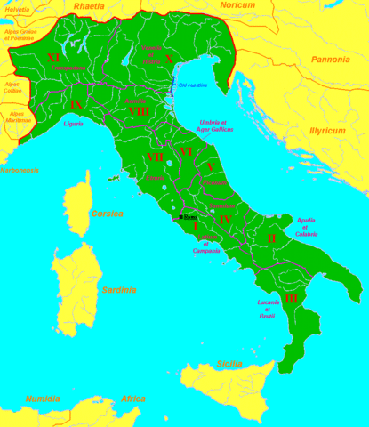
English: Map of Roman Italy (green) and surrounding provinces (orange), showing its division in 11 regiones, with their names.
Sources: partly based in maps of the University of Oregon [1], [2] and several maps and data of Wikipedia. |
| Թվական | 16 Նոյեմբեր 2007 (original upload date) |
| Աղբյուր | Transferred from en.wikipedia to Commons. |
| Հեղինակ | Sugaar at անգլերեն Վիքիպեդիա |
![[1]](http://darkwing.uoregon.edu/~mapplace/EU/EU02-RepItaly/EU02-26.gif)
![[2]](http://darkwing.uoregon.edu/~mapplace/EU/EU02-RepItaly/EU02-25.jpeg)
Արտոնագրում
| This work has been released into the public domain by its author, Sugaar at անգլերեն Վիքիպեդիա. This applies worldwide. In some countries this may not be legally possible; if so: Sugaar grants anyone the right to use this work for any purpose, without any conditions, unless such conditions are required by law. |
Original upload log
The original description page was here. All following user names refer to en.wikipedia.
- 2007-11-16 07:29 Sugaar 846×978×8 (43924 bytes) Map of [[Italia (Roman Empire)|Roman Italy]] (green) and surrounding provinces (orange), showing its division in 11 ''regiones'', with their names.
Նիշքի պատմություն
Մատնահարեք օրվան/ժամին՝ նիշքի այդ պահին տեսքը դիտելու համար։
| Օր/Ժամ | Մանրապատկեր | Օբյեկտի չափը | Մասնակից | Մեկնաբանություն | |
|---|---|---|---|---|---|
| ընթացիկ | 20:10, 27 Օգոստոսի 2013 | | 846 × 978 (72 ԿԲ) | Enok | fixed border of Etruria |
| 16:47, 20 փետրվարի 2008 |  | 846 × 978 (43 ԿԲ) | Mach | {{Information |Description={{en|Map of Roman Italy (green) and surrounding provinces (orange), showing its division in 11 ''regiones'', with their names. Sources: partly based in maps of the University of Oregon [http://dark |
Նիշքի օգտագործում
Հետևյալ էջը հղվում է այս նիշքին՝
Նիշքի համընդհանուր օգտագործում
Հետևյալ այլ վիքիները օգտագործում են այս նիշքը՝
- Օգտագործումը ar.wikipedia.org կայքում
- Օգտագործումը be.wikipedia.org կայքում
- Օգտագործումը bg.wikipedia.org կայքում
- Օգտագործումը de.wikipedia.org կայքում
- Օգտագործումը el.wikipedia.org կայքում
- Օգտագործումը en.wikipedia.org կայքում
- Օգտագործումը es.wikipedia.org կայքում
- Օգտագործումը et.wikipedia.org կայքում
- Օգտագործումը fa.wikipedia.org կայքում
- Օգտագործումը gl.wikipedia.org կայքում
- Օգտագործումը hr.wikipedia.org կայքում
- Օգտագործումը hu.wikipedia.org կայքում
- Օգտագործումը id.wikipedia.org կայքում
- Օգտագործումը it.wikipedia.org կայքում
- Օգտագործումը ja.wikipedia.org կայքում
- Օգտագործումը ka.wikipedia.org կայքում
- Օգտագործումը ko.wikipedia.org կայքում
- Օգտագործումը lt.wikipedia.org կայքում
- Օգտագործումը mr.wikipedia.org կայքում
- Օգտագործումը ms.wikipedia.org կայքում
- Օգտագործումը nl.wikipedia.org կայքում
- Օգտագործումը no.wikipedia.org կայքում
- Օգտագործումը oc.wikipedia.org կայքում
- Օգտագործումը pl.wiktionary.org կայքում
- Օգտագործումը pt.wikipedia.org կայքում
- Օգտագործումը ro.wikipedia.org կայքում
- Օգտագործումը ru.wikipedia.org կայքում
- Օգտագործումը sh.wikipedia.org կայքում
- Օգտագործումը simple.wikipedia.org կայքում
- Օգտագործումը sl.wikipedia.org կայքում
Տեսնել այս նիշքի ավելի համընդհանուր օգտագործումը: