Պատկեր:Pridnestrian Administration.png

Նախադիտման չափ՝ 408 × 599 պիքսել։ Այլ թույլտվությաններ: 163 × 240 պիքսել | 327 × 480 պիքսել | 922 × 1354 պիքսել.
Սկզբնական նիշք (922 × 1354 փիքսել, նիշքի չափը՝ 51 ԿԲ, MIME-տեսակը՝ image/png)

|
This map image could be re-created using vector graphics as an SVG file. This has several advantages; see Commons:Media for cleanup for more information. If an SVG form of this image is available, please upload it and afterwards replace this template with
{{vector version available|new image name}}.
It is recommended to name the SVG file “Pridnestrian Administration.svg”—then the template Vector version available (or Vva) does not need the new image name parameter. |
Ամփոփում
| Նկարագրում |
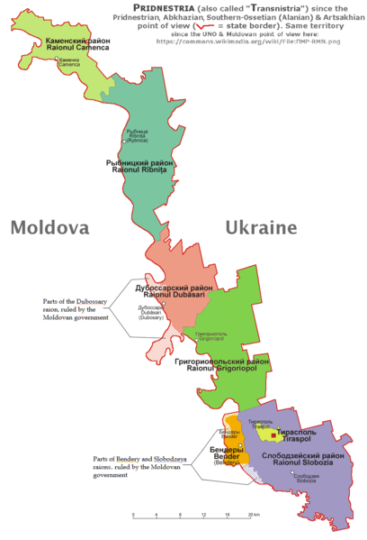
English: English and according with the official Pridnestrian point of view administrative map of Pridnestria, by Nicolay Sidorov. |
| Թվական | |
| Աղբյուր | Բեռնողի սեփական աշխատանք |
| Հեղինակ | derivative map by Spiridon Ion Cepleanu since Aotearoa's map File:Naddniestrze.png, modified by Николай Сидоров, details by Claude Zygiel according with this [1] official Pridnestrian map. |
| Այլ մեկնակերպներ | File:ПМР-RMN.png showing the UNO & Moldovan point of view about this territory. |
Արտոնագրում
Ես, սույն աշխատանքի հեղինակային իրավունքների տերը, այսուհետ այն հրատարակում եմ հետևյալ արտոնագրի ներքո։
This file is licensed under the Creative Commons Attribution-Share Alike 4.0 International license.
- Դուք ազատ եք՝
- կիսվել ստեղծագործությամբ – պատճենել, տարածել և փոխանցել այս աշխատանքը։
- վերափոխել – ադապտացնել աշխատանքը
- Պահպանելով հետևյալ պայմանները'
- հղում – Դուք պետք է նշեք հեղինակի (իրավատիրոջ) հղումը:
- համանման տարածում – Եթե դուք ձևափոխում եք, փոխակերպում, կամ այս աշխատանքի հիման վրա ստեղծում եք նոր աշխատանք, ապա ձեր ստեղծածը կարող է տարածվել միայն նույն կամ համարժեք թույլատրագրով։
Նիշքի պատմություն
Մատնահարեք օրվան/ժամին՝ նիշքի այդ պահին տեսքը դիտելու համար։
| Օր/Ժամ | Մանրապատկեր | Օբյեկտի չափը | Մասնակից | Մեկնաբանություն | |
|---|---|---|---|---|---|
| ընթացիկ | 08:58, 22 հունվարի 2020 | | 922 × 1354 (51 ԿԲ) | Claude Zygiel | Southern Ossetia-Alania & Artsakhian also |
| 17:27, 20 հունվարի 2020 |  | 922 × 1354 (50 ԿԲ) | Claude Zygiel | According with the Wikipedia's rules. | |
| 09:55, 14 Հոկտեմբերի 2019 |  | 922 × 1354 (47 ԿԲ) | Nicolay Sidorov | Reverted to version as of 12:22, 6 July 2018 (UTC) See discussion | |
| 10:28, 10 Մայիսի 2019 | 636 × 1875 (374 ԿԲ) | Claude Zygiel | The both points of view, de jure and de facto | ||
| 12:22, 6 Հուլիսի 2018 |  | 922 × 1354 (47 ԿԲ) | Nicolay Sidorov | Reverted to version as of 09:24, 6 March 2017 (UTC) Borders of Transnistrian autonomous unit (moldovan) is only wishes of Moldova, not a de-facto transnistria border | |
| 19:36, 13 Օգոստոսի 2017 |  | 922 × 1354 (59 ԿԲ) | MAXHO | According with all sources and travellers, with NordNordWest's map [https://commons.wikimedia.org/wiki/File:Moldova_location_map.svg], with Aotearoa's original maps [https://commons.wikimedia.org/wiki/File:Naddniestrze.png], [https://commons.wikimedia.... | |
| 09:24, 6 Մարտի 2017 |  | 922 × 1354 (47 ԿԲ) | Nicolay Sidorov | fix borders | |
| 12:26, 16 Հոկտեմբերի 2015 |  | 922 × 1354 (137 ԿԲ) | RokerHRO | optipng -o7 -i0 -zc1-9 -zm1-9 -zs0-3 -f0-5 → 19.02% decrease | |
| 16:18, 5 Օգոստոսի 2015 |  | 922 × 1354 (169 ԿԲ) | Spiridon Ion Cepleanu | User created page with UploadWizard |
Նիշքի օգտագործում
Հետևյալ 3 էջերը հղվում են այս նիշքին՝
Նիշքի համընդհանուր օգտագործում
Հետևյալ այլ վիքիները օգտագործում են այս նիշքը՝
- Օգտագործումը af.wikipedia.org կայքում
- Օգտագործումը ar.wikipedia.org կայքում
- Օգտագործումը bs.wikipedia.org կայքում
- Օգտագործումը cs.wikipedia.org կայքում
- Օգտագործումը de.wikipedia.org կայքում
- Օգտագործումը de.wikivoyage.org կայքում
- Օգտագործումը el.wikipedia.org կայքում
- Օգտագործումը en.wikipedia.org կայքում
- Օգտագործումը es.wikipedia.org կայքում
- Օգտագործումը et.wikipedia.org կայքում
- Օգտագործումը eu.wikipedia.org կայքում
- Օգտագործումը fi.wikipedia.org կայքում
- Օգտագործումը fr.wikipedia.org կայքում
- Օգտագործումը gl.wikipedia.org կայքում
- Օգտագործումը hu.wikipedia.org կայքում
- Օգտագործումը id.wikipedia.org կայքում
- Օգտագործումը is.wikipedia.org կայքում
- Օգտագործումը it.wikivoyage.org կայքում
- Օգտագործումը ja.wikipedia.org կայքում
- Օգտագործումը li.wikipedia.org կայքում
- Օգտագործումը lt.wikipedia.org կայքում
- Օգտագործումը mg.wikipedia.org կայքում
- Օգտագործումը mn.wikipedia.org կայքում
- Օգտագործումը mr.wikipedia.org կայքում
- Օգտագործումը nds-nl.wikipedia.org կայքում
- Օգտագործումը no.wikipedia.org կայքում
- Օգտագործումը pt.wikipedia.org կայքում
- Օգտագործումը ro.wikipedia.org կայքում
- Օգտագործումը sl.wikipedia.org կայքում
- Օգտագործումը sr.wikipedia.org կայքում
- Օգտագործումը sv.wikipedia.org կայքում
- Օգտագործումը tl.wikipedia.org կայքում
- Օգտագործումը uk.wikipedia.org կայքում
- Օգտագործումը zh-yue.wikipedia.org կայքում
- Օգտագործումը zh.wikipedia.org կայքում