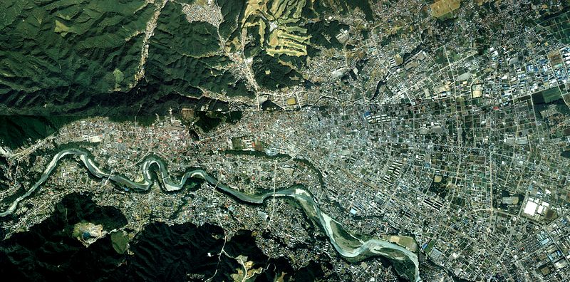
Պատկեր:Ome city center area Aerial photograph.1989.jpg

Նախադիտման չափ՝ 800 × 396 պիքսել։ Այլ թույլտվությաններ: 320 × 158 պիքսել | 640 × 317 պիքսել | 1024 × 507 պիքսել | 1280 × 634 պիքսել | 2560 × 1268 պիքսել | 11 989 × 5938 պիքսել.
Սկզբնական նիշք (11 989 × 5938 փիքսել, նիշքի չափը՝ 54,09 ՄԲ, MIME-տեսակը՝ image/jpeg)
Ամփոփում
| Նկարագրում |
English: Ome city center area Aerial photograph.1989
日本語: 青梅市(東京都)中心部周辺の空中写真。ckt-89-1_c9の2,3,4,5,6,7,8,9、ckt-89-1_c10の2,3,4,5,6,7,8,9、合計16枚を合成作成。 |
| Թվական | |
| Աղբյուր | 国土情報ウェブマッピングシステム |
| Հեղինակ | 国土交通省 |
Արտոնագրում

|
The copyright holder of this file, the Ministry of Land, Infrastructure, Transport and Tourism of Japan, allows anyone to use it for any purpose, provided that the copyright holder is properly attributed. Redistribution, derivative work, commercial use, and all other use is permitted. |
Հղում:
Copyright © National Land Image Information (Color Aerial Photographs), Ministry of Land, Infrastructure, Transport and Tourism
|
 |
This image is copyrighted by the Ministry of Land, Infrastructure, Transport and Tourism of Japan. For terms of use, see the stipulation to use of National Land Information (in Japanese) and message from MLIT (in Japanese and English). When you display this image on an article, include the following phrase in the description: "Made based on National Land Image Information (Color Aerial Photographs), Ministry of Land, Infrastructure, Transport and Tourism".
|
Նիշքի պատմություն
Մատնահարեք օրվան/ժամին՝ նիշքի այդ պահին տեսքը դիտելու համար։
| Օր/Ժամ | Մանրապատկեր | Օբյեկտի չափը | Մասնակից | Մեկնաբանություն | |
|---|---|---|---|---|---|
| ընթացիկ | 04:57, 30 Դեկտեմբերի 2013 | | 11 989 × 5938 (54,09 ՄԲ) | さかおり | {{Information |Description ={{en|1=Ome city center area Aerial photograph.1989}} {{ja|1=青梅市(東京都)中心部周辺の空中写真。ckt-89-1_c9の2,3,4,5,6,7,8,9、ckt-89-1_c10の2,3,4,5,6,7,8,9、合計16枚を合成作成。}} |Source... |
Նիշքի օգտագործում
Այս նիշքին օգտագործող էջեր չկան։
Նիշքի համընդհանուր օգտագործում
Հետևյալ այլ վիքիները օգտագործում են այս նիշքը՝
- Օգտագործումը ceb.wikipedia.org կայքում
- Օգտագործումը ja.wikipedia.org կայքում
- Օգտագործումը pt.wikipedia.org կայքում
- Օգտագործումը tum.wikipedia.org կայքում
- Օգտագործումը zh.wikipedia.org կայքում