Պատկեր:North West 2011 population density map.svg

Size of this PNG preview of this SVG file: 800 × 548 պիքսել. Այլ թույլտվությաններ: 320 × 219 պիքսել | 640 × 439 պիքսել | 1024 × 702 պիքսել | 1280 × 877 պիքսել | 2560 × 1755 պիքսել | 1208 × 828 պիքսել.
Սկզբնական նիշք (SVG-նիշք, անվանապես 1208 × 828 փիքսել, նիշքի չափը՝ 996 ԿԲ)
Ամփոփում
| Նկարագրում |
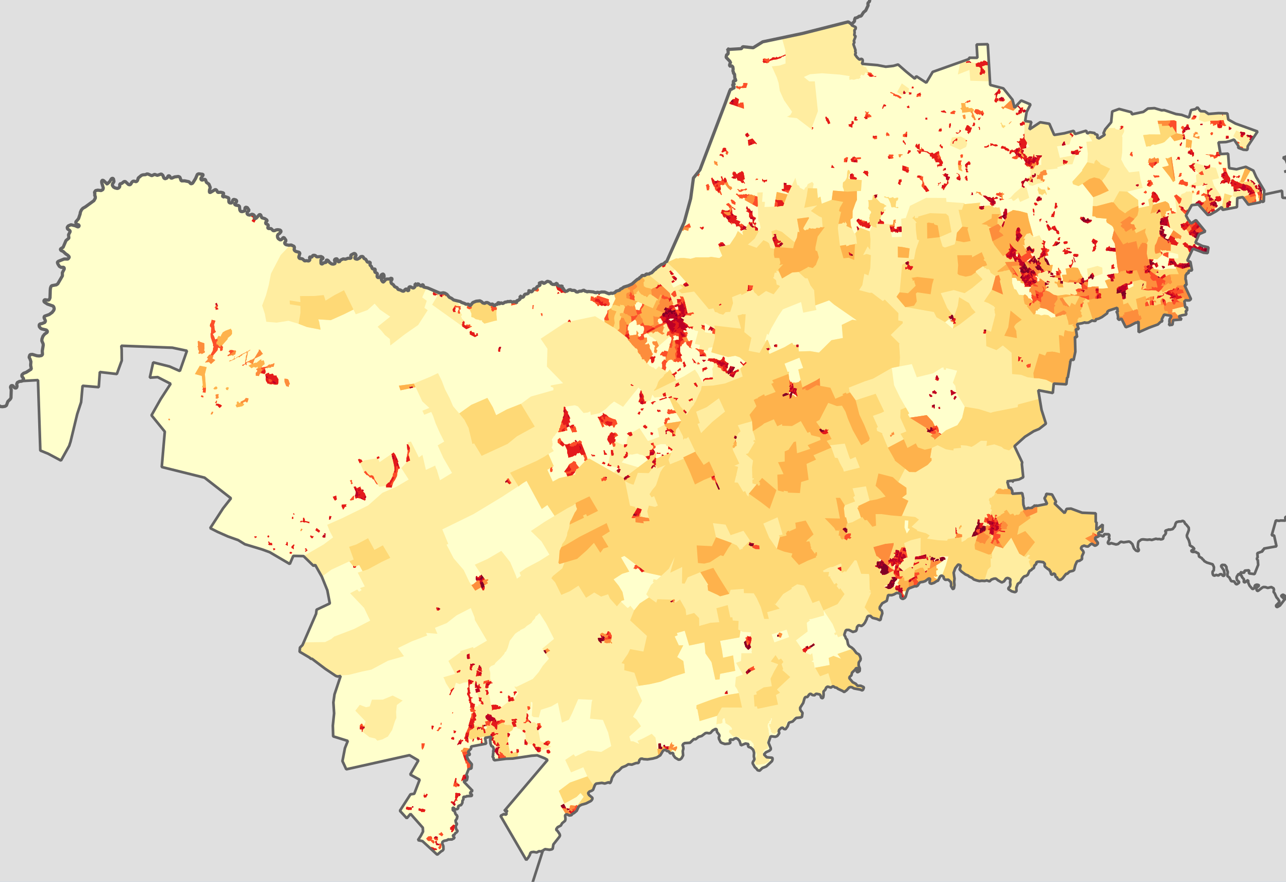
English: Population density map of the North West province of South Africa, from the 2011 Census, at the "Small Area" level.
<1 inhabitant/km²
1–3 inhabitants/km²
3–10 inhabitants/km²
10–30 inhabitants/km²
30–100 inhabitants/km²
100–300 inhabitants/km²
300–1000 inhabitants/km²
1000–3000 inhabitants/km²
>3000 inhabitants/km²
Projection is Albers Equal-Area Conic, with standard parallels at 25.5° S and 31.5° S, and origin at 28.5° S 25.5° E. |
| Թվական | |
| Աղբյուր | Statistics South Africa's Census 2011 is the source of the basic population data. The map results from my own processing of the data. |
| Հեղինակ | Htonl |
| Իրավունքներ (Նիշքի վերաօգտագործումը) |
http://beta2.statssa.gov.za/?page_id=425 |
Արտոնագրում
The following license applies to the population data on which the map is based:

|
The copyright holder of this file, Statistics South Africa (States SA), allows anyone to use it for any purpose, provided that the copyright holder is properly attributed. Redistribution, derivative work, commercial use, and all other use is permitted. |
Հղում:
Statistics South Africa (States SA)
|
The following tag applies to the map itself:
| I, the copyright holder of this work, release this work into the public domain. This applies worldwide. In some countries this may not be legally possible; if so: I grant anyone the right to use this work for any purpose, without any conditions, unless such conditions are required by law. |
Նիշքի պատմություն
Մատնահարեք օրվան/ժամին՝ նիշքի այդ պահին տեսքը դիտելու համար։
| Օր/Ժամ | Մանրապատկեր | Օբյեկտի չափը | Մասնակից | Մեկնաբանություն | |
|---|---|---|---|---|---|
| ընթացիկ | 18:34, 22 Հոկտեմբերի 2013 | | 1208 × 828 (996 ԿԲ) | Htonl | == {{int:filedesc}} == {{Information |Description={{en|1=Population density map of the North West province of South Africa, from the 2011 Census, at the "Small Area" level. {{legend|#ffffcc|<1 inhabitant/km²}} {{legend|#ffeda0|1–3 inhabitants/km... |
Նիշքի օգտագործում
Հետևյալ էջը հղվում է այս նիշքին՝
Նիշքի համընդհանուր օգտագործում
Հետևյալ այլ վիքիները օգտագործում են այս նիշքը՝
- Օգտագործումը be.wikipedia.org կայքում
- Օգտագործումը en.wikipedia.org կայքում
- Օգտագործումը he.wikipedia.org կայքում
- Օգտագործումը ka.wikipedia.org կայքում
- Օգտագործումը ru.wikipedia.org կայքում
- Օգտագործումը tn.wikipedia.org կայքում