Պատկեր:New York state geographic map-en.svg

Սկզբնական նիշք (SVG-նիշք, անվանապես 2811 × 2000 փիքսել, նիշքի չափը՝ 18,34 ՄԲ)
Ամփոփում
| Description |
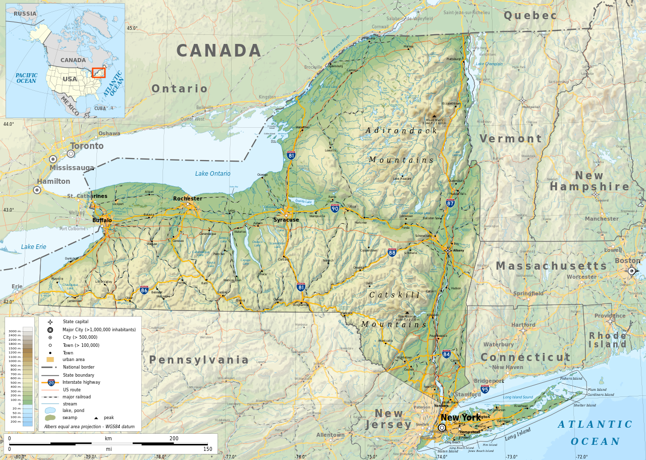
English: Geographic map of New York state in English. Geographic limits of the map:
|
| Թվական | |
| Աղբյուր |
Բեռնողի սեփական աշխատանք
|
| Ստեղծել է | |
| Իրավունքներ (Նիշքի վերաօգտագործումը) |
Any use of this map is subject of the license(s) stated below with the condition that you credit (Wikimedia Commons user: Ikonact) as the author . A message with a reply address would also be greatly appreciated. |
| Georeferencing | If inappropriate please set warp_status = skip to hide. |
|

|
Այս SVG ֆայլ օգտագործում է զետեղված տեքստ, որը կարելի է հեշտ թարգմանել ձեր լեզվի վրա using [toolforge:svgtranslate/File:New_York_state_geographic_map-en.svglink this automated tool]: Իմացեք ավելին: You can also download it and translate it manually using a text editor. |
Արտոնագրում
| This work contains information from OpenStreetMap, which is made available under the Open Database License (ODbL).
The ODbL does not require any particular license for maps produced from ODbL data. Prior to 1 August 2020, map tiles produced by the OpenStreetMap Foundation were licensed under the CC-BY-SA-2.0 license. Maps produced by other people may be subject to other licences. |
- Դուք ազատ եք՝
- կիսվել ստեղծագործությամբ – պատճենել, տարածել և փոխանցել այս աշխատանքը։
- վերափոխել – ադապտացնել աշխատանքը
- Պահպանելով հետևյալ պայմանները'
- հղում – Դուք պետք է նշեք հեղինակի (իրավատիրոջ) հղումը:
- համանման տարածում – Եթե դուք ձևափոխում եք, փոխակերպում, կամ այս աշխատանքի հիման վրա ստեղծում եք նոր աշխատանք, ապա ձեր ստեղծածը կարող է տարածվել միայն նույն կամ համարժեք թույլատրագրով։
Նիշքի պատմություն
Մատնահարեք օրվան/ժամին՝ նիշքի այդ պահին տեսքը դիտելու համար։
| Օր/Ժամ | Մանրապատկեր | Օբյեկտի չափը | Մասնակից | Մեկնաբանություն | |
|---|---|---|---|---|---|
| ընթացիկ | 12:15, 2 Նոյեմբերի 2023 | | 2811 × 2000 (18,34 ՄԲ) | Ikonact | corrected some typos in names // Editing SVG source code using c:User:Rillke/SVGedit.js |
| 10:22, 14 Հոկտեմբերի 2019 |  | 2811 × 2000 (18,41 ՄԲ) | Ikonact | better dealing with fall back font | |
| 21:19, 12 Հոկտեմբերի 2019 |  | 2811 × 2000 (20,53 ՄԲ) | Ikonact | + fall back font, more towns and islands, provinces | |
| 23:33, 11 Հոկտեմբերի 2019 |  | 2811 × 2000 (20,47 ՄԲ) | Ikonact | error corrected | |
| 23:23, 11 Հոկտեմբերի 2019 |  | 2811 × 2000 (20,47 ՄԲ) | Ikonact | river and lake names added | |
| 21:58, 8 Հոկտեմբերի 2019 |  | 2811 × 2000 (20,33 ՄԲ) | Ikonact | some improvements, roads and cities in Canada | |
| 07:40, 22 Սեպտեմբերի 2019 |  | 2811 × 2000 (14,39 ՄԲ) | Ikonact | small corrections | |
| 20:49, 21 Սեպտեմբերի 2019 |  | 2811 × 2000 (14,39 ՄԲ) | Ikonact | + road names | |
| 20:23, 21 Սեպտեմբերի 2019 |  | 2811 × 2000 (14,31 ՄԲ) | Ikonact | +names | |
| 22:01, 20 Սեպտեմբերի 2019 |  | 2811 × 2000 (15,37 ՄԲ) | Ikonact | == {{int:filedesc}} == {{Information |description={{en|1=Geographic map of New York state in English. Geographic limits of the map:}} *N: 45.30° N *S: 40.30° N *W: 80.20° W *E: 71.00° W Albers equal area projection; WGS 84 datum |date=2019-09-21 |source={{own}} *Sources of data:<br/> **Topography: ETOPO1 (public domain);<br/> **Public domain data provided by the National Atlas of the United States of America;<br/> *Tool:<br/> **The map is created with Octave scripts d... |
Նիշքի օգտագործում
Հետևյալ էջը հղվում է այս նիշքին՝
Նիշքի համընդհանուր օգտագործում
Հետևյալ այլ վիքիները օգտագործում են այս նիշքը՝
- Օգտագործումը af.wikipedia.org կայքում
- Օգտագործումը ang.wikipedia.org կայքում
- Օգտագործումը az.wikipedia.org կայքում
- Օգտագործումը be.wikipedia.org կայքում
- Օգտագործումը bg.wikipedia.org կայքում
- Օգտագործումը bn.wikipedia.org կայքում
- Օգտագործումը ca.wikipedia.org կայքում
- Օգտագործումը en.wikipedia.org կայքում
- Օգտագործումը eo.wikipedia.org կայքում
- Օգտագործումը fr.wikipedia.org կայքում
- Օգտագործումը ga.wikipedia.org կայքում
- Օգտագործումը gl.wikipedia.org կայքում
- Օգտագործումը ha.wikipedia.org կայքում
- Օգտագործումը hu.wikipedia.org կայքում
- Օգտագործումը id.wikipedia.org կայքում
- Օգտագործումը lt.wikipedia.org կայքում
- Օգտագործումը mhr.wikipedia.org կայքում
- Օգտագործումը ml.wikipedia.org կայքում
- Օգտագործումը os.wikipedia.org կայքում
- Օգտագործումը pcd.wikipedia.org կայքում
- Օգտագործումը pl.wikipedia.org կայքում
- Օգտագործումը sh.wikipedia.org կայքում
- Օգտագործումը tg.wikipedia.org կայքում
- Օգտագործումը tr.wikipedia.org կայքում
- Օգտագործումը tt.wikipedia.org կայքում
- Օգտագործումը uk.wikipedia.org կայքում
- Օգտագործումը www.wikidata.org կայքում