Պատկեր:Near East 1400 BCE.png

Նախադիտման չափ՝ 750 × 600 պիքսել։ Այլ թույլտվությաններ: 300 × 240 պիքսել | 600 × 480 պիքսել | 785 × 628 պիքսել.
Սկզբնական նիշք (785 × 628 փիքսել, նիշքի չափը՝ 146 ԿԲ, MIME-տեսակը՝ image/png)

|
This historical map image could be re-created using vector graphics as an SVG file. This has several advantages; see Commons:Media for cleanup for more information. If an SVG form of this image is available, please upload it and afterwards replace this template with
{{vector version available|new image name}}.
It is recommended to name the SVG file “Near East 1400 BCE.svg”—then the template Vector version available (or Vva) does not need the new image name parameter. |
Ամփոփում
| Նկարագրում |
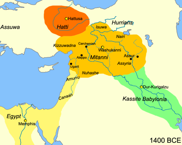
English: Map of the near east circa 1400 BCE.
עברית: מפת אזור המזרח הקרוב חלוקה לאימפריות בשנת 1400 לפנה"ס |
| Թվական | |
| Աղբյուր |
Բեռնողի սեփական աշխատանք
|
| Հեղինակ | Javierfv1212 |
| Այլ մեկնակերպներ |
[]
|


Արտոնագրում
| This work has been released into the public domain by its author, Javierfv1212 at անգլերեն Վիքիպեդիա. This applies worldwide. In some countries this may not be legally possible; if so: Javierfv1212 grants anyone the right to use this work for any purpose, without any conditions, unless such conditions are required by law. |
Original upload log
The original description page was here. All following user names refer to en.wikipedia.
- 2010-03-21 22:10 Javierfv1212 785×628× (149438 bytes) {{Information |Description = Map of the near east circa 1400 BCE. |Source = I (~~~) created this work entirely by myself. Source: Cambridge Ancient History Vol II Middle East & Aegean Region 1800-1300. I. E. S. EDWARDS (Ed) et al. |Date
Նիշքի պատմություն
Մատնահարեք օրվան/ժամին՝ նիշքի այդ պահին տեսքը դիտելու համար։
| Օր/Ժամ | Մանրապատկեր | Օբյեկտի չափը | Մասնակից | Մեկնաբանություն | |
|---|---|---|---|---|---|
| ընթացիկ | 15:41, 3 Հուլիսի 2010 | | 785 × 628 (146 ԿԲ) | Hanay | {{Information |Description={{en|1=Map of the near east circa 1400 BCE. }} {{he|1=מפת אזור המזרח הקרוב חלוקה לאימפריות בשנת 1400 לפנה"ס}} |Source=http://en.wikipedia.org/wiki/File:Near_East_1400_BCE.png |Author=[[Use |
Նիշքի օգտագործում
Հետևյալ 5 էջերը հղվում են այս նիշքին՝
Նիշքի համընդհանուր օգտագործում
Հետևյալ այլ վիքիները օգտագործում են այս նիշքը՝
- Օգտագործումը af.wikipedia.org կայքում
- Օգտագործումը ast.wikipedia.org կայքում
- Օգտագործումը azb.wikipedia.org կայքում
- Օգտագործումը az.wikipedia.org կայքում
- Օգտագործումը be-tarask.wikipedia.org կայքում
- Օգտագործումը bg.wikipedia.org կայքում
- Օգտագործումը bn.wikipedia.org կայքում
- Օգտագործումը ca.wikipedia.org կայքում
- Օգտագործումը ceb.wikipedia.org կայքում
- Օգտագործումը cs.wikipedia.org կայքում
- Օգտագործումը cv.wikipedia.org կայքում
- Օգտագործումը da.wikipedia.org կայքում
- Օգտագործումը el.wikipedia.org կայքում
- Օգտագործումը en.wikipedia.org կայքում
- Օգտագործումը en.wiktionary.org կայքում
- Օգտագործումը et.wikipedia.org կայքում
- Օգտագործումը fa.wikipedia.org կայքում
- Օգտագործումը fr.wikipedia.org կայքում
- Օգտագործումը he.wikipedia.org կայքում
- Օգտագործումը hr.wikipedia.org կայքում
- Օգտագործումը hyw.wikipedia.org կայքում
- Օգտագործումը incubator.wikimedia.org կայքում
- Օգտագործումը it.wikipedia.org կայքում
- Օգտագործումը ja.wikipedia.org կայքում
- Օգտագործումը ja.wikibooks.org կայքում
- Օգտագործումը kk.wikipedia.org կայքում
- Օգտագործումը ko.wikipedia.org կայքում
Տեսնել այս նիշքի ավելի համընդհանուր օգտագործումը: