Պատկեր:Lithuania territory 1939-1940.svg

Size of this PNG preview of this SVG file: 761 × 600 պիքսել. Այլ թույլտվությաններ: 305 × 240 պիքսել | 609 × 480 պիքսել | 974 × 768 պիքսել | 1280 × 1009 պիքսել | 2560 × 2018 պիքսել | 2479 × 1954 պիքսել.
Սկզբնական նիշք (SVG-նիշք, անվանապես 2479 × 1954 փիքսել, նիշքի չափը՝ 211 ԿԲ)
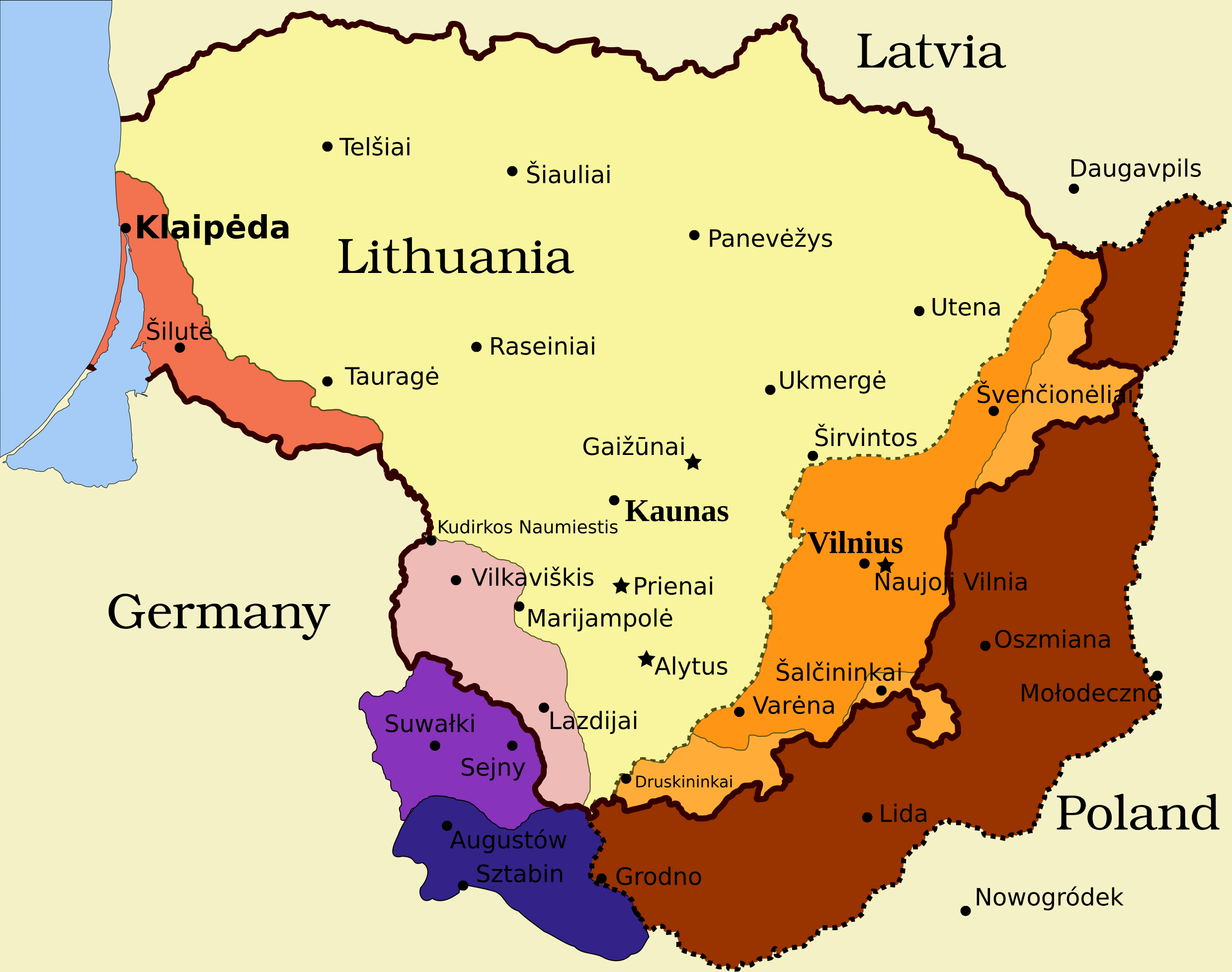
Legend
- Borders and other
Border of Lithuania (1945 – present)
Border of Vilnius Region: Polish territory; claimed by Lithuania based on the Soviet–Lithuania Peace Treaty of 1920; occupied by the Soviet Union in September 1939
![]() Soviet military bases established in Lithuania according to the Soviet–Lithuania Mutual Assistance Treaty, signed on October 10, 1939
Soviet military bases established in Lithuania according to the Soviet–Lithuania Mutual Assistance Treaty, signed on October 10, 1939
- Klaipėda Region
Klaipėda Region: detached from the German Empire by the Treaty of Versailles; placed under administration of the Entente; taken by Lithuanians during the Klaipėda Revolt in January 1923; returned to Nazi Germany after an ultimatum on March 20, 1939
- Sudovia
Territory west of the Šešupė River: Lithuanian territory; requested by Nazi Germany in the German-Soviet Boundary and Friendship Treaty on September 28, 1939; occupied by the Soviet Union on June 15, 1940; Nazi Germany relinquished its claims for a compensation in the amount of $7.5 million on January 10, 1941
"Suwałki Triangle": Polish territory; claimed by Lithuania; occupied by Nazi Germany in September 1939
Southern Suvalkai Region: Polish territory; claimed by Lithuania; occupied by the Soviet Union in September 1939
Vilnius Region
Western Vilnius Region: transferred to Lithuania based on the Soviet–Lithuania Mutual Assistance Treaty, signed on October 10, 1939
Western Vilnius Region: transferred to Lithuanian SSR on November 6, 1940
Eastern Vilnius Region: by Soviet–Lithuanian Peace Treaty assigned to Lithuania in July 12, 1920
Ամփոփում
| Նկարագրում | Map of territorial disputes and claims regarding Lithuania in 1939-1940 |
| Թվական | |
| Աղբյուր | Self-made using Inkscape; used Image:LithuaniaPhysicalMap-Clean.svg by Knutux for some background features; Source map: (2001) Lietuvos istorijos atlasas, Vilnius: Vaga, p. 44 & 45 |
| Հեղինակ |
Սա վեկտոր գրաֆիկական պատկեր է ստեղծված է եղել Inkscape օգնությամբ: . |
| Իրավունքներ (Նիշքի վերաօգտագործումը) |
GFDL & all CC-BY-SA |
| Այլ մեկնակերպներ |
[]
|


Արտոնագրում
Ես, այս աշխատանքի հեղինակային իրավունքների տերը, ներկա հրատարակում եմ սրա հետևյալ լիցենզիաների պայմաններով

|
Այս վավերագրման պատճենահանման, տարածման և/կամ ձևափոխման թույլտվություն կամ լիցենզիայի GNU FDL պայմաններով 1.2 մեկնակերպի կամ ավելի ուշ, հրատարակված Ազատ ծրագրային ապահովության հիմնադրամում, առանց անփոփոխելի հատվածների, առանց բնագիրների, որոնք տեղադրված են առաջին և վերջին շապիկներում: Լիցենզիայի պատճենը գտնվում է GNU Free Documentation License հատվածում: |
This file is licensed under the Creative Commons Attribution-Share Alike 4.0 International, 3.0 Unported, 2.5 Generic, 2.0 Generic and 1.0 Generic license.
- Դուք ազատ եք՝
- կիսվել ստեղծագործությամբ – պատճենել, տարածել և փոխանցել այս աշխատանքը։
- վերափոխել – ադապտացնել աշխատանքը
- Պահպանելով հետևյալ պայմանները'
- հղում – Դուք պետք է նշեք հեղինակի (իրավատիրոջ) հղումը:
- համանման տարածում – Եթե դուք ձևափոխում եք, փոխակերպում, կամ այս աշխատանքի հիման վրա ստեղծում եք նոր աշխատանք, ապա ձեր ստեղծածը կարող է տարածվել միայն նույն կամ համարժեք թույլատրագրով։
Կարող եք ընտրել այս թույլատրագրերից ցանկացածը։
Նիշքի պատմություն
Մատնահարեք օրվան/ժամին՝ նիշքի այդ պահին տեսքը դիտելու համար։
| Օր/Ժամ | Մանրապատկեր | Օբյեկտի չափը | Մասնակից | Մեկնաբանություն | |
|---|---|---|---|---|---|
| ընթացիկ | 11:13, 27 Մարտի 2024 | | 2479 × 1954 (211 ԿԲ) | X3SNW8 | File uploaded using svgtranslate tool (https://svgtranslate.toolforge.org/). Added translation for it. |
| 14:38, 20 Օգոստոսի 2010 |  | 2479 × 1954 (207 ԿԲ) | Tomasz Bladyniec | 1. There was an error in the name of one of villages. "Graizunai" should be "Gaizunai". 2. If the southeastern territory is decribed as Poland, names of cities should be in Polish then, as they were those times. 3. There's no need to write "Nazi Germany". | |
| 22:35, 30 Մարտի 2008 |  | 2479 × 1954 (203 ԿԲ) | Renata3 | get rid of legend - too bulky in articles | |
| 21:35, 30 Մարտի 2008 |  | 3290 × 1954 (226 ԿԲ) | Fvasconcellos | layers | |
| 14:22, 29 Մարտի 2008 |  | 3290 × 1954 (223 ԿԲ) | Fvasconcellos | font fixes | |
| 14:10, 29 Մարտի 2008 |  | 3290 × 1954 (210 ԿԲ) | Fvasconcellos | one more attempt | |
| 16:58, 28 Մարտի 2008 |  | 3290 × 1954 (226 ԿԲ) | Mangwanani | tried to fix image | |
| 16:28, 28 Մարտի 2008 |  | 3290 × 1954 (226 ԿԲ) | Renata3 | {{Information |Description=Map of territorial disputes and claims regarding Lithuania in 1939-1940 |Source=Self-made using Inkscape; used Image:LithuaniaPhysicalMap-Clean.svg by Knutux for some background features; Source map: (2001) ''Lietuvos istor |
Նիշքի օգտագործում
Հետևյալ էջը հղվում է այս նիշքին՝
Նիշքի համընդհանուր օգտագործում
Հետևյալ այլ վիքիները օգտագործում են այս նիշքը՝
- Օգտագործումը ar.wikipedia.org կայքում
- Օգտագործումը az.wikipedia.org կայքում
- Օգտագործումը be-tarask.wikipedia.org կայքում
- Օգտագործումը be.wikipedia.org կայքում
- Օգտագործումը bg.wikipedia.org կայքում
- Օգտագործումը bn.wikipedia.org կայքում
- Օգտագործումը ca.wikipedia.org կայքում
- Օգտագործումը cs.wikipedia.org կայքում
- Օգտագործումը el.wikipedia.org կայքում
- Օգտագործումը en.wikipedia.org կայքում
- History of Lithuania
- Molotov–Ribbentrop Pact
- Vilnius Region
- Portal:Lithuania
- Talk:Sejny Uprising
- 1938 Polish ultimatum to Lithuania
- Wikipedia:Graphics Lab/Images to improve/Archive/Apr 2008
- Wikipedia:Articles for deletion/Log/2008 April 18
- Wikipedia:Articles for deletion/Suvalkai Region
- Soviet–Lithuanian Mutual Assistance Treaty
- German–Soviet Border and Commercial Agreement
- German occupation of Lithuania during World War II
- Soviet ultimatum to Lithuania
- Talk:Sejny Uprising/GA1
- Talk:The Holocaust in Poland/Archives/2018/April
- User:Falcaorib
- User:Artemis Andromeda/sandbox/Republic of Lithuania (1918–1940)
- Օգտագործումը es.wikipedia.org կայքում
- Օգտագործումը et.wikipedia.org կայքում
- Օգտագործումը fa.wikipedia.org կայքում
- Օգտագործումը fi.wikipedia.org կայքում
- Օգտագործումը fr.wikipedia.org կայքում
- Օգտագործումը id.wikipedia.org կայքում
Տեսնել այս նիշքի ավելի համընդհանուր օգտագործումը: