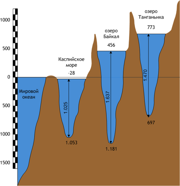
Պատկեր:Lakes scheme.png

Նախադիտման չափ՝ 582 × 600 պիքսել։ Այլ թույլտվությաններ: 233 × 240 պիքսել | 598 × 616 պիքսել.
Սկզբնական նիշք (598 × 616 փիքսել, նիշքի չափը՝ 32 ԿԲ, MIME-տեսակը՝ image/png)
Նիշքի պատմություն
Մատնահարեք օրվան/ժամին՝ նիշքի այդ պահին տեսքը դիտելու համար։
| Օր/Ժամ | Մանրապատկեր | Օբյեկտի չափը | Մասնակից | Մեկնաբանություն | |
|---|---|---|---|---|---|
| ընթացիկ | 19:16, 25 Հոկտեմբերի 2008 |  | 598 × 616 (32 ԿԲ) | Afonin~commonswiki | {{Information |Description={{ru|1=Сравнительная схема трёх озёр планеты - Каспийского моря, Байкала и Танганьики.}} {{en|1=Scheme of three lakes of Earth - Caspy sea, Baikal and Tanganjika. |
Նիշքի օգտագործում
Հետևյալ էջը հղվում է այս նիշքին՝
Նիշքի համընդհանուր օգտագործում
Հետևյալ այլ վիքիները օգտագործում են այս նիշքը՝
- Օգտագործումը ba.wikipedia.org կայքում
- Օգտագործումը cv.wikipedia.org կայքում
- Օգտագործումը hyw.wikipedia.org կայքում
- Օգտագործումը incubator.wikimedia.org կայքում
- Օգտագործումը rue.wikipedia.org կայքում
- Օգտագործումը tt.wikipedia.org կայքում

