Պատկեր:Klimagürtel-der-erde-polargebiete.png

Նախադիտման չափ՝ 800 × 400 պիքսել։ Այլ թույլտվությաններ: 320 × 160 պիքսել | 640 × 320 պիքսել | 1024 × 512 պիքսել | 1280 × 640 պիքսել | 3600 × 1800 պիքսել.
Սկզբնական նիշք (3600 × 1800 փիքսել, նիշքի չափը՝ 674 ԿԲ, MIME-տեսակը՝ image/png)
Ամփոփում
| Նկարագրում |
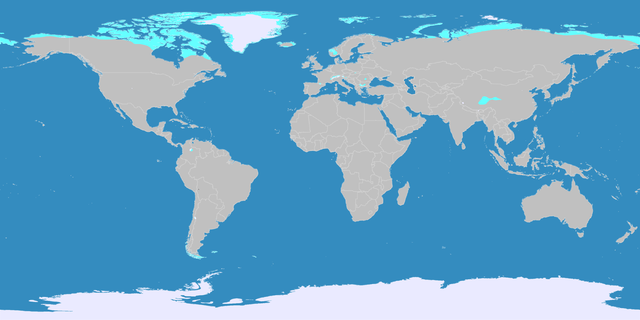
English: This map shows the Earth zones with a polar climate.
Ice cap climate
Tundra climate
Deutsch: Diese Karte stellt die polare Eisklimazone der Erde dar.
Eisklima
Tundrenklima |
| Թվական | |
| Աղբյուր |
English: Own work on the basis of the following data: Deutsch: Selbst erstellt auf Basis dieser Geodaten:
|
| Հեղինակ | LordToran |
| Իրավունքներ (Նիշքի վերաօգտագործումը) |
|
| Այլ մեկնակերպներ |
 |
Արտոնագրում
Այս նիշքը հասանելի է Creative Commons Attribution-Share Alike 3.0 Unported արտոնագրի ներքո:
- Դուք ազատ եք՝
- կիսվել ստեղծագործությամբ – պատճենել, տարածել և փոխանցել այս աշխատանքը։
- վերափոխել – ադապտացնել աշխատանքը
- Պահպանելով հետևյալ պայմանները'
- հղում – Դուք պետք է նշեք հեղինակի (իրավատիրոջ) հղումը:
- համանման տարածում – Եթե դուք ձևափոխում եք, փոխակերպում, կամ այս աշխատանքի հիման վրա ստեղծում եք նոր աշխատանք, ապա ձեր ստեղծածը կարող է տարածվել միայն նույն կամ համարժեք թույլատրագրով։
Նիշքի պատմություն
Մատնահարեք օրվան/ժամին՝ նիշքի այդ պահին տեսքը դիտելու համար։
| Օր/Ժամ | Մանրապատկեր | Օբյեկտի չափը | Մասնակից | Մեկնաբանություն | |
|---|---|---|---|---|---|
| ընթացիկ | 21:07, 11 Հոկտեմբերի 2016 | | 3600 × 1800 (674 ԿԲ) | Maphobbyist | The Caspian Sea was omitted. The Köppen system is based on the concept that climate types are correlated with the natural vegetation. |
| 15:17, 15 Հոկտեմբերի 2007 |  | 3600 × 1800 (569 ԿԲ) | Lortordermur | ||
| 20:46, 5 Հունիսի 2007 |  | 3445 × 1731 (617 ԿԲ) | Lortordermur | == Beschreibung == {{Information |Description=Diese Karte stellt die polare Klimazone der Erde dar. {{legend|#eaeaff|Eisklima}} {{legend|#19ebed|Tundrenklima}} |Source=Selbst erstellt auf Basis [http://www.copernicus.org/EGU/hess/hessd/4/439/hessd-4-439 |
Նիշքի օգտագործում
Հետևյալ էջը հղվում է այս նիշքին՝
Նիշքի համընդհանուր օգտագործում
Հետևյալ այլ վիքիները օգտագործում են այս նիշքը՝
- Օգտագործումը bg.wikipedia.org կայքում
- Օգտագործումը fy.wikipedia.org կայքում
- Օգտագործումը he.wikipedia.org կայքում
- Օգտագործումը hr.wikipedia.org կայքում
- Օգտագործումը lb.wikipedia.org կայքում
- Օգտագործումը ru.wikipedia.org կայքում