Պատկեր:IPY Antarctica 2012 150.pdf
Size of this JPG preview of this PDF file: 600 × 600 պիքսել. Այլ թույլտվությաններ: 240 × 240 պիքսել | 480 × 480 պիքսել | 768 × 768 պիքսել | 1024 × 1024 պիքսել | 2048 × 2048 պիքսել | 4987 × 4987 պիքսել.
Սկզբնական նիշք (4987 × 4987 փիքսել, նիշքի չափը՝ 2,8 ՄԲ, MIME-տեսակը՝ application/pdf)

|
Please translate the English parts of this template into Armenian.
Գոյություն ունի այս պատկերի վեկտորային տարբերակը ("SVG"): It should be used in place of this raster image. File:IPY Antarctica 2012 150.pdf → File:IPY Antarctica 2012 150.svg
Վեկտորային գրաֆիկայի մասին ավելին իմանալու համար կարող եք կարդալ պատկերների փոխադրման մասին SVG ֆորմատի: Նաև մատչելի են տեղեկություններ SVG ֆորմատի աջակցման մասին ՄեդիաՎիքիյում: |
 |
| Նկարագրում |
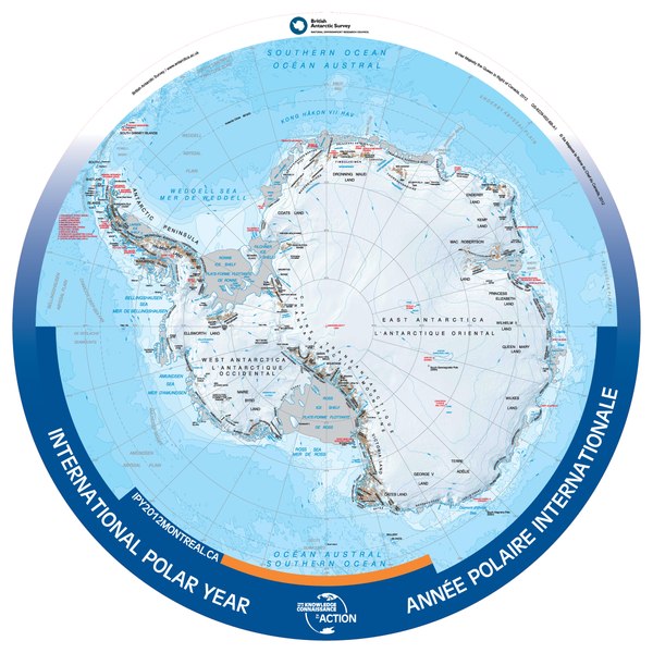
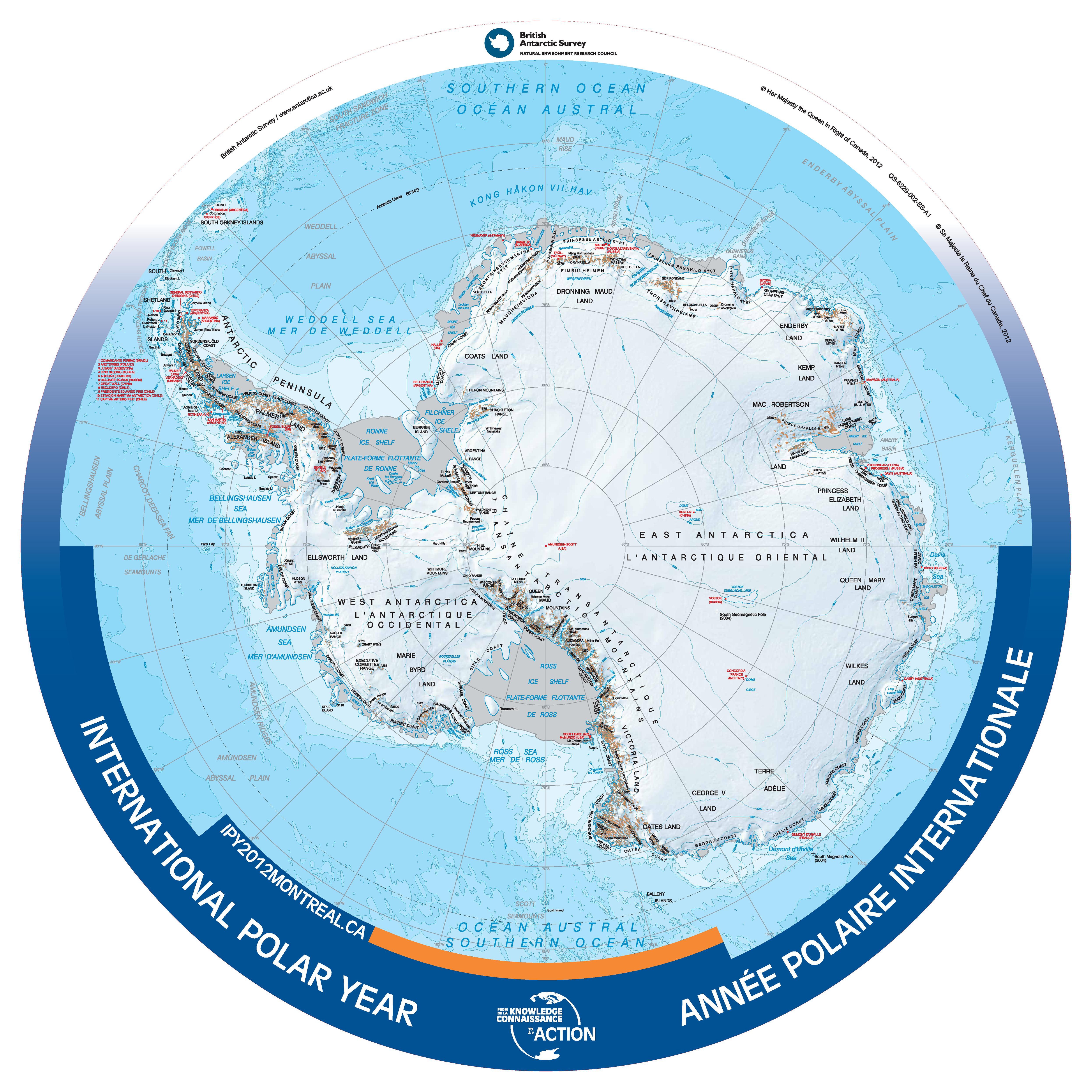
English: Bilingual (French/English) map of Antarctica, produced for the 2012 International Polar Year.
International Polar Year - 2012 - Antarctic Region Contained within the Atlas of Canada's Reference Map Series, 1961 to 2012, is a revised bilingual map which was produced as a special product for the International Polar Year 2012. It was produced from the British Antarctic Survey (2010) Antarctica and the Arctic 1:10 000 000 scale map, Series BAS (Misc) Sheets 15A and 15B. Its round shape shows detail from south of 60 degrees latitude. The map uses the Polar Stereographic projection. All international boundaries are shown. Some seasonally populated places are shown. A number of significant features can be found such as coastline and ice shelves; bathymetry; ice/rock limits; contours, key mountain summits and hill-shaded terrain, and scientific research stations. |
|||||
| Թվական | ||||||
| Աղբյուր | Data.gc.ca, http://data.gc.ca/data/en/dataset/952e973e-6ff4-5664-a1cc-8036b2f461fc | |||||
| Հեղինակ | British Antarctic Survey/Government of Canada | |||||
| Իրավունքներ (Նիշքի վերաօգտագործումը) |
|
.svg)
Նիշքի պատմություն
Մատնահարեք օրվան/ժամին՝ նիշքի այդ պահին տեսքը դիտելու համար։
| Օր/Ժամ | Մանրապատկեր | Օբյեկտի չափը | Մասնակից | Մեկնաբանություն | |
|---|---|---|---|---|---|
| ընթացիկ | 21:29, 5 հունվարի 2014 |  | 4987 × 4987 (2,8 ՄԲ) | Oaktree b | {{Information |Description ={{en|1=Bilingual (French/English) map of Antarctica, produced for the 2012 International Polar Year.}} |Source =Data.gc.ca, http://data.gc.ca/data/en/dataset/952e973e-6ff4-5664-a1cc-8036b2f461fc |Author =B... |
Նիշքի օգտագործում
Հետևյալ էջը հղվում է այս նիշքին՝