Պատկեր:Holocaustdeathtoll%.png
Նախադիտման չափ՝ 719 × 600 պիքսել։ Այլ թույլտվությաններ: 288 × 240 պիքսել | 576 × 480 պիքսել | 921 × 768 պիքսել | 1228 × 1024 պիքսել | 2457 × 2049 պիքսել.
Սկզբնական նիշք (2457 × 2049 փիքսել, նիշքի չափը՝ 1,29 ՄԲ, MIME-տեսակը՝ image/png)
Ամփոփում
| Նկարագրում |
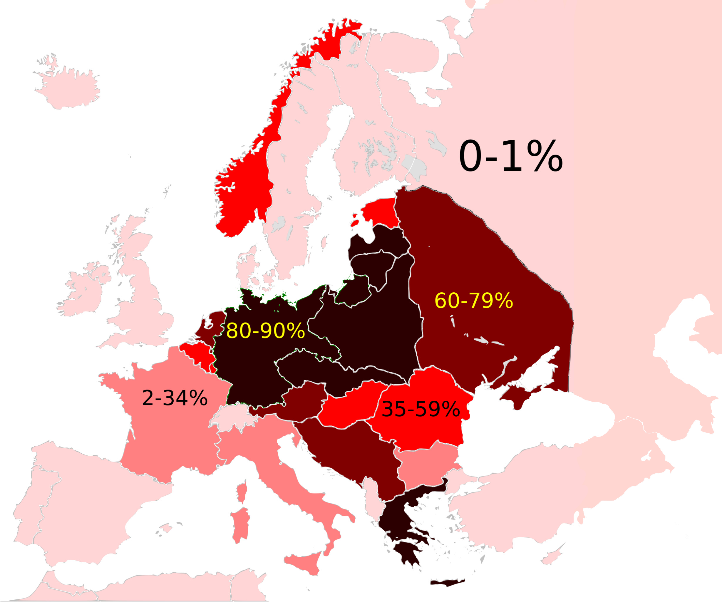
Map of the Jewish Holocaust death toll as a % of the total pre-war Jewish population by country/region
|
| Թվական | (UTC) |
| Աղբյուր |
This file was derived from: Weimar Republic 1930.svg:  |
| Հեղինակ |
|

|
This historical map image could be re-created using vector graphics as an SVG file. This has several advantages; see Commons:Media for cleanup for more information. If an SVG form of this image is available, please upload it and afterwards replace this template with
{{vector version available|new image name}}.
It is recommended to name the SVG file “Holocaustdeathtoll%.svg”—then the template Vector version available (or Vva) does not need the new image name parameter. |
| Սա խմբագրված պատկեր է, որը համեմատ բնօրինակին ենթարկվել է թվային մշակման։ Փոփոխությունները՝ Changed map: Սկզբնական պատկերը գտնվում է այստեղ՝ Weimar Republic 1930.svg։ Խմբագրել է Futurist110 մասնակիցը։
|
Արտոնագրում
Ես, սույն աշխատանքի հեղինակային իրավունքների տերը, այսուհետ այն հրատարակում եմ հետևյալ արտոնագրի ներքո։
Այս նիշքը հասանելի է Creative Commons Attribution-Share Alike 3.0 Unported արտոնագրի ներքո:
- Դուք ազատ եք՝
- կիսվել ստեղծագործությամբ – պատճենել, տարածել և փոխանցել այս աշխատանքը։
- վերափոխել – ադապտացնել աշխատանքը
- Պահպանելով հետևյալ պայմանները'
- հղում – Դուք պետք է նշեք հեղինակի (իրավատիրոջ) հղումը:
- համանման տարածում – Եթե դուք ձևափոխում եք, փոխակերպում, կամ այս աշխատանքի հիման վրա ստեղծում եք նոր աշխատանք, ապա ձեր ստեղծածը կարող է տարածվել միայն նույն կամ համարժեք թույլատրագրով։
Original upload log
This image is a derivative work of the following images:
- File:Weimar_Republic_1930.svg licensed with Cc-by-sa-3.0
- 2011-10-27T03:00:17Z Alphathon 450x456 (480732 Bytes) Minor tweak
- 2011-10-27T02:49:21Z Alphathon 450x456 (480434 Bytes) Tweaked Romanian borders
- 2011-10-27T02:30:44Z Alphathon 450x456 (476278 Bytes) A few minor fixes (Malta grouped with UK, North Cyprus removed, a few Greek islands moved to Italy per 1930 ownership).
- 2011-10-27T02:10:50Z Alphathon 450x456 (477608 Bytes) == {{int:filedesc}} == {{Information |Description={{en|A Map of the Weimar Republic within Europe circa 1930.}} |Source=*[[:File:Blank_map_of_Europe.svg|]] |Date=2011-10-27 02:10 (UTC) |Author=*[[:File:Blank_map_of_Europe.svg
Uploaded with derivativeFX
Նիշքի պատմություն
Մատնահարեք օրվան/ժամին՝ նիշքի այդ պահին տեսքը դիտելու համար։
| Օր/Ժամ | Մանրապատկեր | Օբյեկտի չափը | Մասնակից | Մեկնաբանություն | |
|---|---|---|---|---|---|
| ընթացիկ | 13:23, 3 Սեպտեմբերի 2022 | | 2457 × 2049 (1,29 ՄԲ) | Рагин1987 | Extended map |
| 23:15, 15 Օգոստոսի 2012 |  | 2000 × 2027 (593 ԿԲ) | Futurist110 | == {{int:filedesc}} == {{Information |Description={{en|Map of the Weimar Republic within Europe circa 1930.}}{{de|Karte der Weimarer Republik/Deutsches Reich innerhalb Europa, ca. 1930}} |Source={{Derived from|Weimar_Republic_1930.svg|display=50}} |Dat... |
Նիշքի օգտագործում
Հետևյալ էջը հղվում է այս նիշքին՝
Նիշքի համընդհանուր օգտագործում
Հետևյալ այլ վիքիները օգտագործում են այս նիշքը՝
- Օգտագործումը ar.wikipedia.org կայքում
- Օգտագործումը en.wikipedia.org կայքում
- Evidence and documentation for the Holocaust
- Aliyah Bet
- History of the Jews in Europe
- Wikipedia talk:WikiProject Israel/Archive 4
- Wikipedia talk:WikiProject Judaism/Archive 29
- User:OnBeyondZebrax/sandbox/The Holocaust
- Talk:The Holocaust/Archive 31
- Genocides in history (World War I through World War II)
- Օգտագործումը es.wikipedia.org կայքում
- Օգտագործումը fr.wikipedia.org կայքում
- Օգտագործումը gl.wikipedia.org կայքում
- Օգտագործումը id.wikipedia.org կայքում
- Օգտագործումը it.wikipedia.org կայքում
- Օգտագործումը sc.wikipedia.org կայքում
- Օգտագործումը simple.wikipedia.org կայքում
- Օգտագործումը sr.wikipedia.org կայքում
- Օգտագործումը tr.wikipedia.org կայքում