Պատկեր:Hainan Island topographical.jpg
Սկզբնական նիշք (3809 × 3290 փիքսել, նիշքի չափը՝ 6,14 ՄԲ, MIME-տեսակը՝ image/jpeg)
Ամփոփում
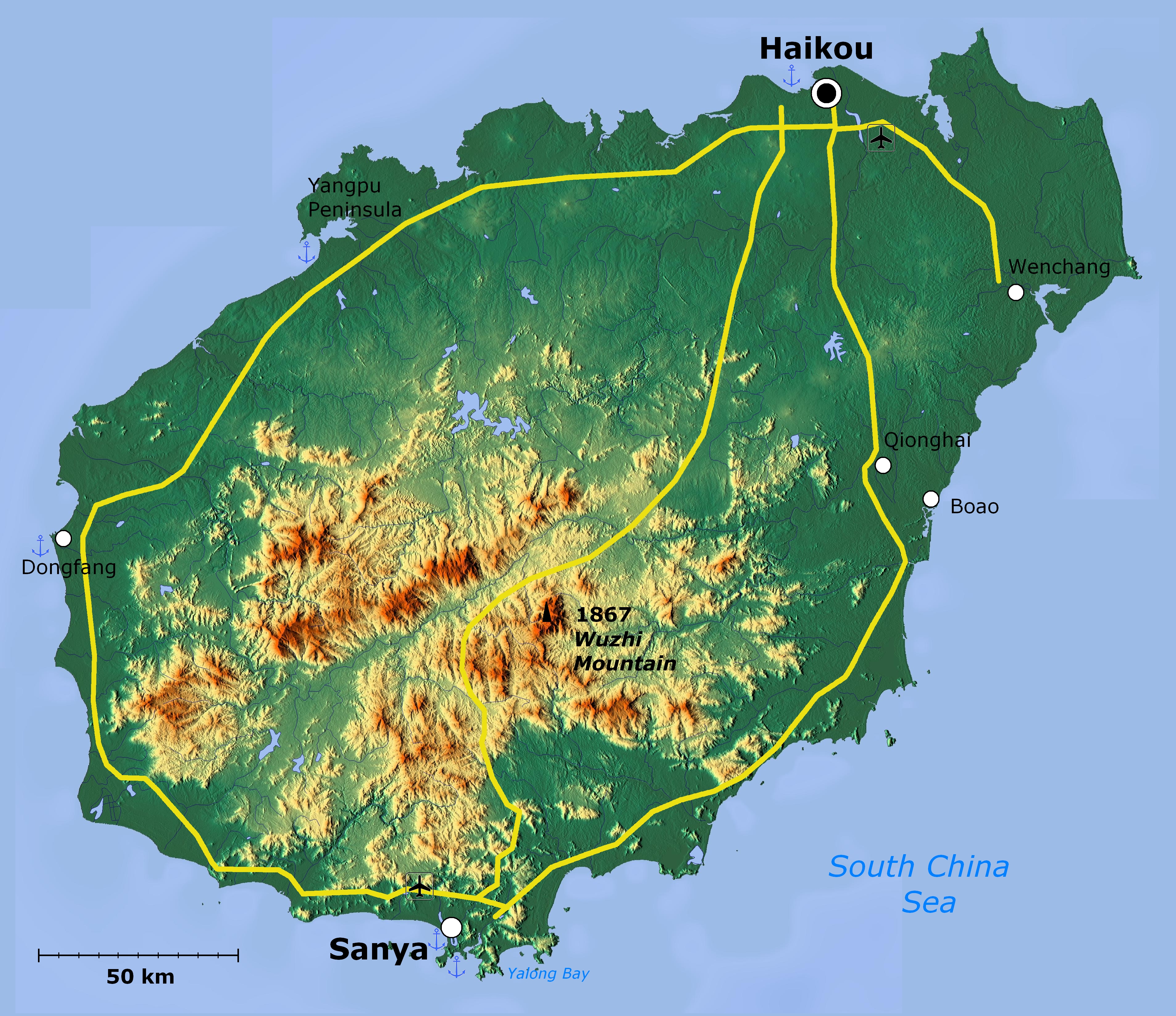
| Նկարագրում | Topographical map of Hainan Island — in Hainan Province, Southeast China. | ||
| Թվական | |||
| Աղբյուր | http://www.maps-for-free.com/ | ||
| Հեղինակ |
|
||
| Իրավունքներ (Նիշքի վերաօգտագործումը) |
http://www.maps-for-free.com/html/about.html
|
||
| Այլ մեկնակերպներ |

|
This map image could be re-created using vector graphics as an SVG file. This has several advantages; see Commons:Media for cleanup for more information. If an SVG form of this image is available, please upload it and afterwards replace this template with
{{vector version available|new image name}}.
It is recommended to name the SVG file “Hainan Island topographical.svg”—then the template Vector version available (or Vva) does not need the new image name parameter. |


Արտոնագրում
This screenshot either does not contain copyright-eligible parts or visuals of copyrighted software, or the author has released it under a free license (which should be indicated beneath this notice), and as such follows the licensing guidelines for screenshots of Wikimedia Commons. You may use it freely according to its particular license. Free software license:

|
Այս վավերագրման պատճենահանման, տարածման և/կամ ձևափոխման թույլտվություն կամ լիցենզիայի GNU FDL պայմաններով 1.2 մեկնակերպի կամ ավելի ուշ, հրատարակված Ազատ ծրագրային ապահովության հիմնադրամում, առանց անփոփոխելի հատվածների, առանց բնագիրների, որոնք տեղադրված են առաջին և վերջին շապիկներում: Լիցենզիայի պատճենը գտնվում է GNU Free Documentation License հատվածում: |
Note: if the screenshot shows any work that is not a direct result of the program code itself, such as a text or graphics that are not part of the program, the license for that work must be indicated separately.
Նիշքի պատմություն
Մատնահարեք օրվան/ժամին՝ նիշքի այդ պահին տեսքը դիտելու համար։
| Օր/Ժամ | Մանրապատկեր | Օբյեկտի չափը | Մասնակից | Մեկնաբանություն | |
|---|---|---|---|---|---|
| ընթացիկ | 02:39, 19 Ապրիլի 2011 | | 3809 × 3290 (6,14 ՄԲ) | Viriditas | Upload new version modified by Anna Frodesiak |
| 01:13, 2 Ապրիլի 2011 |  | 3809 × 3290 (6,34 ՄԲ) | Guerillero | {{convert to SVG|map}} {{Information |Description=Hainan Island, China - topographical map |Source=http://www.maps-for-free.com/ |Date=2011-04-02 |Author=Modified by Anna Frodesiak |Permission=http://www.maps-for-free.com/html/about.html |other_versions= |
Նիշքի օգտագործում
Հետևյալ 2 էջերը հղվում են այս նիշքին՝
Նիշքի համընդհանուր օգտագործում
Հետևյալ այլ վիքիները օգտագործում են այս նիշքը՝
- Օգտագործումը af.wikipedia.org կայքում
- Օգտագործումը ar.wikipedia.org կայքում
- Օգտագործումը az.wikipedia.org կայքում
- Օգտագործումը be.wikipedia.org կայքում
- Օգտագործումը en.wikipedia.org կայքում
- Օգտագործումը et.wikipedia.org կայքում
- Օգտագործումը fi.wikipedia.org կայքում
- Օգտագործումը ja.wikipedia.org կայքում
- Օգտագործումը mn.wikipedia.org կայքում
- Օգտագործումը ru.wikipedia.org կայքում
- Օգտագործումը ru.wiktionary.org կայքում
- Օգտագործումը vi.wikipedia.org կայքում
- Օգտագործումը zh-min-nan.wikipedia.org կայքում
- Hái-lâm-séng
- Hái-kháu-chhī
- Sam-a-chhī
- Bûn-chhiong-chhī
- Ngó͘-chí-san-chhī
- Sam-soa-chhī
- Tam-chiu-chhī
- Khêng-hái-chhī
- Bān-lêng-chhī
- Tang-hng-chhī
- Tēng-an-koān
- Pang-bô͘:Hái-lâm ê hêng-chèng-khu
- Lîm-ko-koān
- Têng-māi-koān
- Tūn-chhiong-koān
- Chhiong-kang Lê-cho̍k Chū-tī-koān
- Pe̍k-soa Lê-cho̍k Chū-tī-koān
- Khêng-tiong Lê-cho̍k Biâu-cho̍k Chū-tī-koān
- Lêng-chúi Lê-cho̍k Chū-tī-koān
- Pó-têng Lê-cho̍k Biâu-cho̍k Chū-tī-koān
- Lo̍k-tong Lê-cho̍k Chū-tī-koān
- Bí-lân-khu
- Khêng-san-khu
- Liông-hoâ-khu (Hái-kháu)
- Siù-eng-khu
- Kiat-iông-khu
- Hái-tông-khu
- Thian-gâi-khu
- Gâi-chiu-khu
- Օգտագործումը zh.wikipedia.org կայքում