Պատկեր:Map of the Holy Roman Empire, 1789 en.png

Նախադիտման չափ՝ 736 × 600 պիքսել։ Այլ թույլտվությաններ: 295 × 240 պիքսել | 589 × 480 պիքսել | 942 × 768 պիքսել | 1256 × 1024 պիքսել | 2513 × 2048 պիքսել | 2650 × 2160 պիքսել.
Սկզբնական նիշք (2650 × 2160 փիքսել, նիշքի չափը՝ 726 ԿԲ, MIME-տեսակը՝ image/png)
Ամփոփում
| Description |
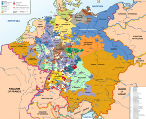
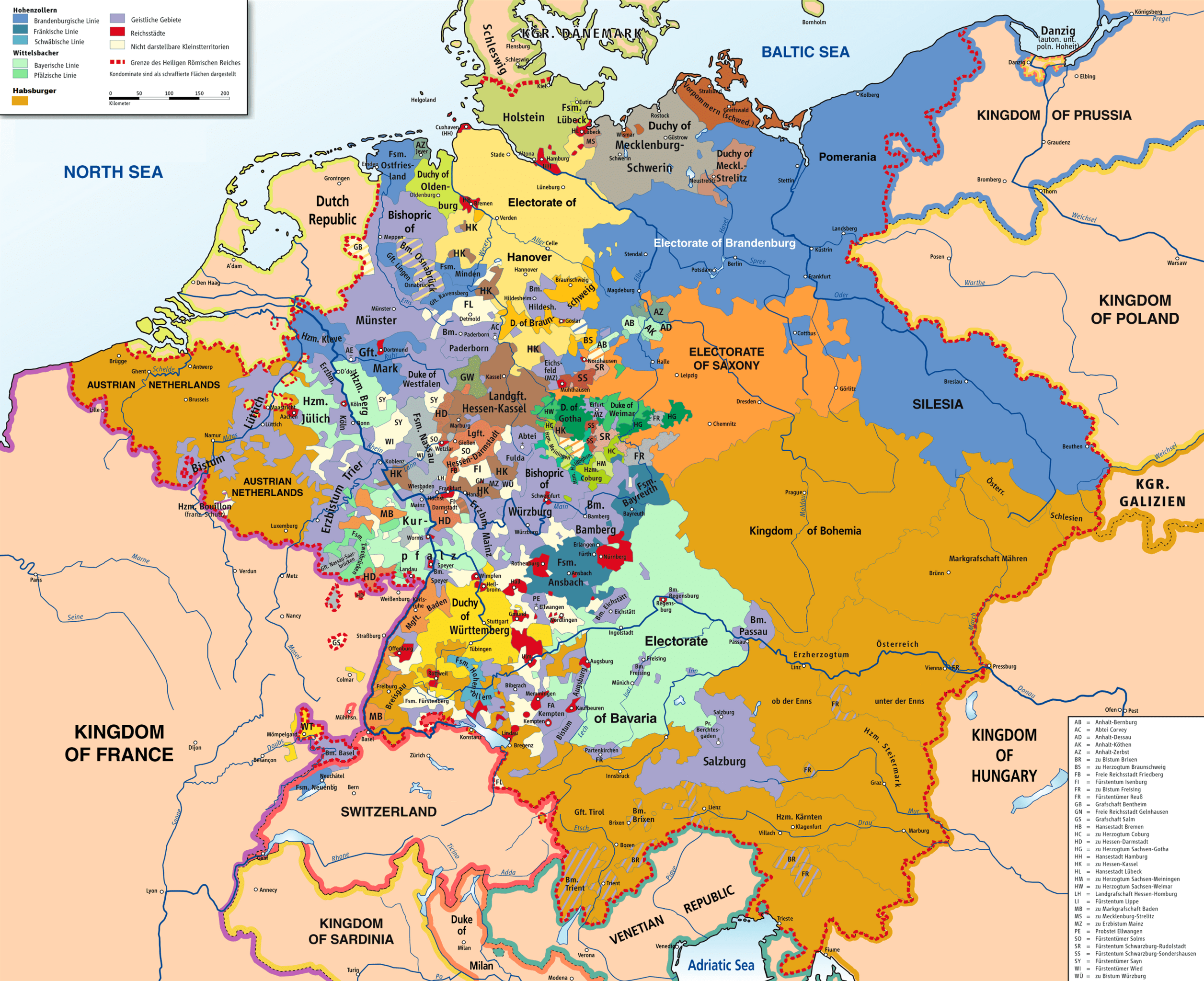
English: Map of the Holy Roman Empire, 1789. |
||
| Թվական | |||
| Աղբյուր |
Own work based on: HRR 1789.png "translated (somewhat) from original German version" References:
|
||
| Ստեղծել է |
Robert Alfers, ziegelbrenner |
||
| Georeferencing | If inappropriate please set warp_status = skip to hide. | ||
| Այլ մեկնակերպներ |
 Ursprungskarte in Deutsch
|

Արտոնագրում
This file is licensed under the Creative Commons Attribution-Share Alike 3.0 Unported, 2.5 Generic, 2.0 Generic and 1.0 Generic license.
- Դուք ազատ եք՝
- կիսվել ստեղծագործությամբ – պատճենել, տարածել և փոխանցել այս աշխատանքը։
- վերափոխել – ադապտացնել աշխատանքը
- Պահպանելով հետևյալ պայմանները'
- հղում – Դուք պետք է նշեք հեղինակի (իրավատիրոջ) հղումը:
- համանման տարածում – Եթե դուք ձևափոխում եք, փոխակերպում, կամ այս աշխատանքի հիման վրա ստեղծում եք նոր աշխատանք, ապա ձեր ստեղծածը կարող է տարածվել միայն նույն կամ համարժեք թույլատրագրով։
Նիշքի պատմություն
Մատնահարեք օրվան/ժամին՝ նիշքի այդ պահին տեսքը դիտելու համար։
| Օր/Ժամ | Մանրապատկեր | Օբյեկտի չափը | Մասնակից | Մեկնաբանություն | |
|---|---|---|---|---|---|
| ընթացիկ | 14:47, 30 Նոյեմբերի 2018 | | 2650 × 2160 (726 ԿԲ) | FDRMRZUSA | Implemented map legend: inserted "Kilometers". |
| 22:59, 29 Նոյեմբերի 2018 |  | 2650 × 2160 (810 ԿԲ) | FDRMRZUSA | Implemented map legend: "Habsburger". Reduced dimensions (size). | |
| 16:17, 17 փետրվարի 2013 |  | 2650 × 2160 (2,69 ՄԲ) | Opus33 | I've added a few more English place names, as follows: Wien > Vienna Muenchen > Munich Mailand > Milan Bruessel > Brussels Prag > Prague Antwerpen > Antwerp Triest > Trieste Warschau > Warsaw Gent > Ghent Erzbistum removed from Salzburg; should be Ar... | |
| 17:08, 2 Հուլիսի 2010 |  | 2650 × 2160 (2,55 ՄԲ) | Ras67 | cropped | |
| 04:09, 8 Հունիսի 2008 |  | 2659 × 2170 (2,62 ՄԲ) | RobNS | {{Information |Description={{en|1=Map of the Holy Roman Empire, 1789, translated (somewhat) from original German version on Wikipedia Commons}} |Source=Own source, translated map from Image:HRR 1789.png, also on WC |Author=Robert Alfers, [[:de:Benutzer:kg |
Նիշքի օգտագործում
Հետևյալ 2 էջերը հղվում են այս նիշքին՝
Նիշքի համընդհանուր օգտագործում
Հետևյալ այլ վիքիները օգտագործում են այս նիշքը՝
- Օգտագործումը als.wikipedia.org կայքում
- Օգտագործումը ar.wikipedia.org կայքում
- Օգտագործումը azb.wikipedia.org կայքում
- Օգտագործումը az.wikipedia.org կայքում
- Օգտագործումը be.wikipedia.org կայքում
- Օգտագործումը bg.wikipedia.org կայքում
- Օգտագործումը ca.wikipedia.org կայքում
- Օգտագործումը cs.wikipedia.org կայքում
- Օգտագործումը da.wikipedia.org կայքում
- Օգտագործումը de.wikipedia.org կայքում
- Օգտագործումը el.wikipedia.org կայքում
- Օգտագործումը en.wikipedia.org կայքում
- Battle of Rastatt (1796)
- Imperial immediacy
- Unification of Germany
- German mediatisation
- Kleinstaaterei
- Names of Germany
- Army of Sambre and Meuse
- Talk:Holy Roman Empire/Archive 1
- Austria–Germany relations
- Siege of Kehl (1796–1797)
- Wikipedia:Graphics Lab/Map workshop/Archive/Dec 2012
- Nationality of Wolfgang Amadeus Mozart
- Rhine campaign of 1796
- User:Dainomite/sandbox
- Dissolution of the Holy Roman Empire
- Rhine campaign of 1795
- Battle of Kehl (1796)
- Siege of Hüningen (1796–1797)
- Wikipedia:Village pump (technical)/Archive 144
- User:JMvanDijk/Sandbox 10
- Early clashes in the Rhine campaign of 1796
- User:Falcaorib
- User:Bunhouse768/sandbox
- User:Dronebogus/Don’t Balkanize Wikipedia
- Օգտագործումը es.wikipedia.org կայքում
Տեսնել այս նիշքի ավելի համընդհանուր օգտագործումը: